| **RU6** | |||
| **GCCC\_R6\_CTR** | Canarias Control | 123.650 | **Sector principal** de control del ACC de Canarias. Cubre toda la parte doméstica del FIR. |
Siguiendo la filosofía **TopDown**, este sector dará los servicios de las dependencias no conectadas en su área de responsabilidad.
--- #### DESDOBLES [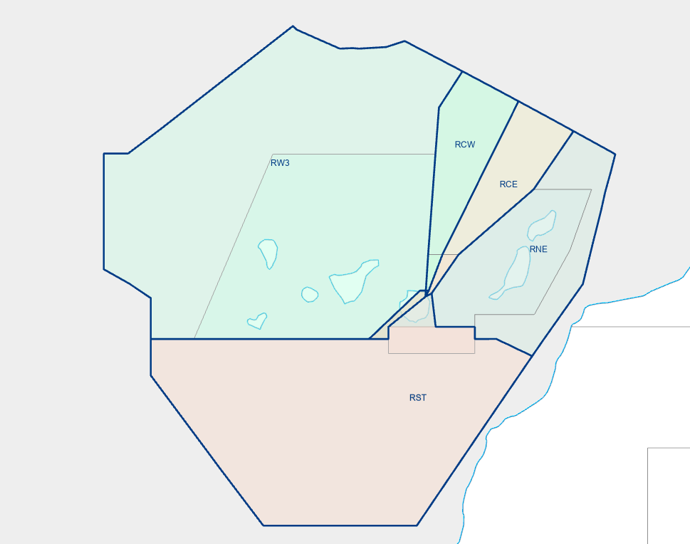](https://biblioteca.vatsimspain.es/uploads/images/gallery/2025-05/gccc.png)| **POSICIÓN** | **SECTORES** | **INDICATIVO** | **FRECUENCIA** | **NOTAS** |
| GCCC\_RCW\_CTR | [**RCW**](https://biblioteca.vatsimspain.es/books/fir-canarias-gccc/page/canarias-control-rcw "RCW") | Canarias Control | 130.950 MHz | **Sector central oeste** de control del ACC de Canarias. Alimentador para llegadas a **GCLP y GCXO por SAMAR**. |
| GCCC\_RC2\_CTR | **RCE+[RCW](https://biblioteca.vatsimspain.es/books/fir-canarias-gccc/page/canarias-control-rcw "RCW")** | Canarias Control | 126.825 MHz | **Sector central** de control del ACC de Canarias. Gestiona las **salidas por VASTO**. *Asume RCW cuando no esté conectado GCCC\_RCW\_CTR* |
| GCCC\_RW3\_CTR | **RW3+[RCW](https://biblioteca.vatsimspain.es/books/fir-canarias-gccc/page/canarias-control-rcw "RCW")** | Canarias Control | 126.500 MHz | **Sector oeste** de control del ACC de Canarias. Este sector a parte de gestionar las rutas que discurren por él, funcionará cómo alimentador para llegadas **por ORTIS y KONBA**. *Asume RCW cuando no esté conectado GCCC\_RC2\_CTR o GCCC\_RCW\_CTR* |
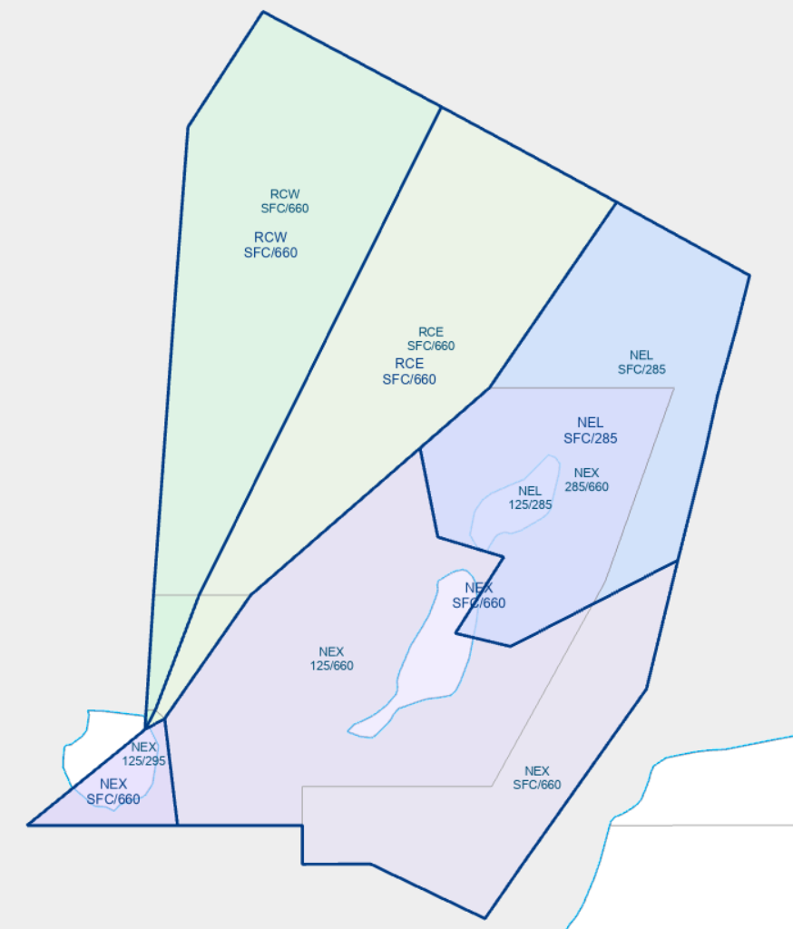
| GCCC\_NEL\_CTR | [**NEL**](https://biblioteca.vatsimspain.es/books/fir-canarias-gccc/page/canarias-control-nel) | Canarias Control | 128.975 MHz | Alimentador para llegadas a **GCRR y GCFV por TERTO, RUSIK y DEVLA**. *Cubre hasta FL285* |
| GCCC\_RNE\_CTR | **NEX+[NEL](https://biblioteca.vatsimspain.es/books/fir-canarias-gccc/page/canarias-control-nel)** | Canarias Control | 129.100 MHz | **Sector noreste** de control del ACC de Canarias. Este sector a parte de gestionar las rutas que discurren por él, funcionará cómo alimentador para llegadas a través de **RUSIK**. *Asume NEL cuando no esté conectado GCCC\_NEL\_CTR* |
| GCCC\_RES\_CTR | **RST+NEX+[NEL](https://biblioteca.vatsimspain.es/books/fir-canarias-gccc/page/canarias-control-nel)+RCE** | Canarias Control | 127.900 MHz | **Sector este y sur** de control del ACC de Canarias. Este sector gestiona las rutas que discurren por él y asignará niveles de vuelos correctos para los tráficos entrando y saliendo del sector oceánico. Además funcionará cómo alimentador para llegadas **por REMGI, ODEGI y URQUI**. *Asume NEX+NEL+RCE cuando no esté conectado GCCC\_RNE\_CTR, GCCC\_NEL\_CTR o GCCC\_RC2\_CTR* |
El sector **RST** nunca puede operar solo; siempre debe combinarse, como mínimo, con otro sector
Detalle de la sectorización RCW, RCE, NEX y NEL:
[](https://biblioteca.vatsimspain.es/uploads/images/gallery/2025-08/Yqkimage.png) --- #### OWNERSHIP| **RST** | **NEL** | **NEX** | **RCE** | **RCW** | **RW3** |
| **GCCC\_NEL\_CTR** | **GCCC\_RCW\_CTR** | ||||
| **GCCC\_RNE\_CTR** | **GCCC\_RC2\_CTR** | ||||
| **GCCC\_RES\_CTR** | **GCCC\_RW3\_CTR** | ||||
| **GCCC\_R6\_CTR** | |||||
| **POSICIÓN** | **CÓDIGO** |
| GCCC\_R6\_CTR | CCR6 |
| GCCC\_RES\_CTR | CRES |
| GCCC\_RW3\_CTR | CRW3 |
| GCCC\_RNE\_CTR | CRNE |
| GCCC\_RC2\_CTR | CRC2 |
| GCCC\_RCW\_CTR | CRCW |
Al igual que en la vida real, en Canarias se usará el CPDLC por encima de **FL285** y para aquellas comunicaciones que no requieran de urgencia **(non time-critical communications)**
---Se recomienda no usar FL240 y FL250 para los interinsulares
*\*El nivel de crucero coordinado (En-route Clearance Level) se considerará correctamente coordinado con los sectores vecinos si se cumple una de las siguientes condiciones:* - *El nivel está introducido en el campo XFL de la Sector Exit List al menos 5 minutos antes de que cruce el límite del sector* - *El nivel ha sido coordinado por voz* **Sobrevuelos:** - Tráficos que se alejen de las islas FL PAR - Tráficos que se acerquen a las islas FL IMPAREl cambio de FL para los vuelos que entren y salgan del UIR se realizará en el sector RST
Las aerovías unidireccionales podrán ser voladas tanto a nivel PAR como IMPAR
--- #### VELOCIDADES - **<250 kt** por debajo de FL100 [](https://biblioteca.vatsimspain.es/uploads/images/gallery/2025-10/HiIimage.png) --- #### VUELOS VFR - Se solicitará a la aeronave que notifique la **zona de vuelo, el número de personas a bordo y el tiempo de operación**, salvo que ya se disponga de dicha información - Se solicitará a la aeronave que confirmen su posición y estado de la oepración al menos cada **30 minutos** - En caso de toma en una base o aeródromo no sujeto a control se le informará del **fin de servicio de control** en el momento que vaya a abandonar el espacio aéreo controlado --- #### OBSERVATORIOS Tanto la isla de La Palma como Tenerife albergan algunos de los observatorios astronómicos más importantes del mundo. Por este motivo, se han definido áreas con forma de cono invertido en las que **las operaciones de aeronaves están terminantemente prohibidas**, salvo en el caso de tráfico militar o misiones humanitarias. Estas áreas pueden consultarse mediante la combinación de teclas **'Alt' + '9'** [](https://biblioteca.vatsimspain.es/uploads/images/gallery/2025-05/Nopimage.png) --- ### **CARTAS DE ACUERDO (LoA)** > [España - Maghreb](https://archivos.vatsimspain.es/Operaciones/LOAs/Maghreb/LoA_Maghreb.pdf "España - Maghreb") > [España - Portugal](https://archivos.vatsimspain.es/Operaciones/LOAs/Portugal/LoA_Portugal.pdf "España - Portugal")La lectura de las Cartas de Acuerdo es obligatoria antes de conectarse en Canarias Control
--- ### **MANUAL OPERATIVO** En el siguiente enlace encontrarás el **Manual Operativo de Canarias Control**, donde podrás conocer en detalle el funcionamiento de este FIR. > [Manual Operativo GCCC](https://biblioteca.vatsimspain.es/books/gccc-sXH/page/canarias-control-manual-operativo "Manual Operativo GCCC") --- ### **INFORMACIÓN ADICIONAL**Si has encontrado información errónea en esta página o hay algo que crees que podrías mejorar, comunicalo a operaciones a través de la [página de contacto](https://vatsimspain.es/vacc/contacto/ "página de contacto")
**Log de versiones (ACCSP54)** 1558357 - Redacción inicial. (27/01/2025) **(ACCSP2)** 1495376 - Actualización para la nueva sectorización (28/04/2025) **(ACCSP2)** 1495376 - Adición GCCC\_NEL\_CTR (26/08/2025) **(ACCSP2)** 1495376 - Añadido apartado Niveles de vuelo, Manual Operativo CPDLC y cambios de estilo (16/10/2025)
# Canarias Control | RCW ### **GENERAL**| **POSICIÓN** | **SECTORES** | **INDICATIVO** | **FRECUENCIA** |
| GCCC\_RCW\_CTR | **RCW** | Canarias Control | 130.950 MHz |
| GCCC\_RC2\_CTR | **RCE+RCW** | Canarias Control | 126.825 MHz |
| GCCC\_RW3\_CTR | **RW3+RCW** | Canarias Control | 126.500 MHz |
Las posiciones están ordenadas por preferencia, de arriba hacia abajo
[](https://biblioteca.vatsimspain.es/uploads/images/gallery/2025-10/0Qtimage.png)Revisa la [Información General de Ruta de Canarias](https://biblioteca.vatsimspain.es/books/fir-canarias-gccc/page/canarias-control-informacion-general "Información General de Ruta de Canarias"), ya que contiene datos aplicables a todos los sectores
--- ### **COORDINACIÓN ENTRE VOLÚMENES** [](https://biblioteca.vatsimspain.es/uploads/images/gallery/2025-10/Iyfimage.png)| **DESDE** | **HACIA** | **NIVEL** | **PROCEDIMIENTO** |
| RCW | RCE | 240 | SID GCXO |
| 280 | SID GCLA | ||
| ECL impar | Interinsulares GCLP RWY21 | ||
| RNW | ECL | STAR GCLA STAR GCXO VIA SAMAR | |
| NBE | 250 | STAR GCXO vía LARYS | |
| FGC | 130 | STAR GCLP (libres de tráfico, incluido interinsular por LARYS o GDV) | |
| RST | ECL | Sobrevuelos |
| **DESDE** | **HACIA** | **NIVEL** | **PROCEDIMIENTO** |
| RCE | RCW | 300 | SID GCFV RWY19 a SAMAR |
| 250 | STAR GCXO | ||
| 240 | SID GCLP/GCRR/GCFV | ||
| ECL | STAR GCLA Interinsulares GCLP RWY21 | ||
| RNW | 280 | SID GCXO/GCTS via KASAS SID GCLA | |
| NBE | 240 | SID GCXO | |
| ECL | Interinsulares | ||
| RST | ECL PAR | Sobrevuelos |
Si has encontrado información errónea en esta página o hay algo que crees que podrías mejorar, comunicalo a operaciones a través de la [página de contacto](https://vatsimspain.es/vacc/contacto/ "página de contacto")
**Log de versiones (ACCSP2)** 1495376 - Redacción inicial. (19/10/2025)
# Canarias Control | NEL ### **GENERAL**| **POSICIÓN** | **SECTOR** | **INDICATIVO** | **FRECUENCIA** |
| GCCC\_NEL\_CTR | **NEL** | Canarias Control | 128.975 MHz |
Revisa la [Información General de Ruta de Canarias](https://biblioteca.vatsimspain.es/books/fir-canarias-gccc/page/canarias-control-informacion-general "Información General de Ruta de Canarias"), ya que contiene datos aplicables a todos los sectores
--- ### **COORDINACIÓN ENTRE VOLÚMENES** [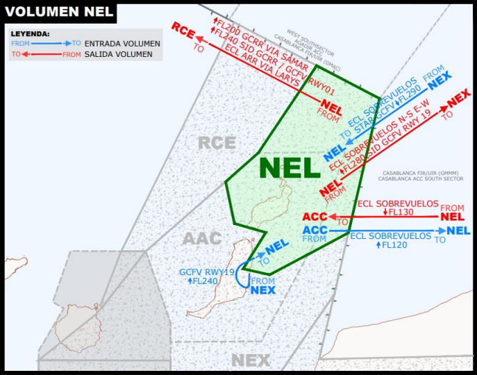](https://biblioteca.vatsimspain.es/uploads/images/gallery/2025-10/3dMnel.png)| **DESDE** | **HACIA** | **NIVEL** | **PROCEDIMIENTO** |
| NEL | AAC | 130 | STAR de TERTO/DEVLA a GCRR y de TERTO/RUSIK a GCFV |
| ECL 120 o inferior | Sobrevuelos y entradas a aeropuertos canarios por debajo de F130 | ||
| RCE | 240 | SID GCRR/GCFV (RWY01) a VASTO SID GCFV (RWY 01) a SAMAR SID GCRR a DESUM | |
| 200 | SID GCRR a SAMAR | ||
| NEX | ECL 280 o inferior | Sobrevuelos a F280 o inferior de este a oeste y de norte a sur Entradas a aeropuertos canarios a F280 o inferior | |
| 280 | Salidas GCFV (RWY19) a KORAL que requieran más alto |
| **DESDE** | **HACIA** | **NIVEL** | **PROCEDIMIENTO** |
| NEX | NEL | 290 | STAR de TERTO a GCFV |
| 240 | SID GCFV RWY19 por KORAL | ||
| ECL 280 o inferior | Sobrevuelos a F280 o inferior de oeste a este y de sur a norte. | ||
| AAC | 120 | SID GCRR/GCFV (RWY01) a SAMAR, VASTO, DESUM y KORAL, excepto SID GCFV RWY19 |
*DESCIENDA VÍA STAR A (nivel) // DESCEND VIA STAR TO (level)* *SUBA VÍA SID A (nivel) // CLIMB VIA SID TO (level)*
--- ### **INFORMACIÓN ADICIONAL**Si has encontrado información errónea en esta página o hay algo que crees que podrías mejorar, comunicalo a operaciones a través de la [página de contacto](https://vatsimspain.es/vacc/contacto/ "página de contacto")
**Log de versiones (ACCSP2)** 1495376 - Redacción inicial. (19/10/2025)
# Aproximaciones Documentación de las posiciones de aproximación gestionadas desde el ACC de Canarias y desde las torres de Tenerife. # Canarias Norte Baja (INB) | TMA Canarias #### ORGANIZACIÓN DEL ESPACIO AÉREO [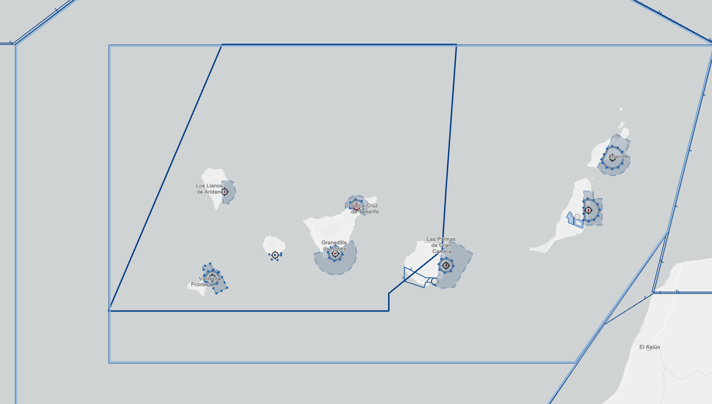](https://biblioteca.vatsimspain.es/uploads/images/gallery/2025-03/image.png) - **TMA Canarias:** El contorno azul que abarca el archipiélago canario. Cubre desde SFC a FL145. Se clasifica cómo **Clase D** desde 1000FT AGL o el límite superior de los FIZ/ATZ/CTR hasta **FL145. Clase C FL145-FL460. - **CTR Tenerife Sur:** El polígono sombreado azul sobre el sur de Tenerife. Cubre desde SFC hasta 1000ft AGL. Clase D. - **ATZ Tenerife Sur:** Circunferencia sobre el sur de Tenerife. Cubre desde SFC hasta 3000ft. Clase D. - **CTR Tenerife Norte:** El polígono sombreado azul sobre el norte de Tenerife. Cubre desde SFC hasta 4500ft AGL. Clase D. - **ATZ Tenerife Norte:** Poligono incluido dentro del CTR sobre el norte de Tenerife. Cubre desde SFC hasta 3000ft AGL. Clase D. - **CTR La Palma:** Poligono sobre La Palma. Cubre desde SFC hasta 3000ft. Clase D. - **CTR Hierro:** Poligono sombreado azul sobre Hierro. Cubre desde SFC hasta 2700ft. Clase D. - **FIZ La Gomera:** Poligono sobre La Gomera. Cubre desde SFC hasta 1000ft AGL. Clase G. Adicionalmente, el ACC de Canarias cuenta con varios espacios aéreos delegados a Tenerife Norte APP y Tenerife sur APP. --- #### **DELEGACIONES** ##### DELEGACIÓN ATS DE CANARIAS ACC A TENERIFE NORTE APP Por acuerdo entre CANARIAS ACC y TENERIFE NORTE APP, el servicio de tránsito aéreo lo proporcionará TENERIFE NORTE APP en el espacio aéreo sombreado en el espacio aéreo sombreado en la imagen entre 1000ft AGL/1650ft AMSL y FL075. [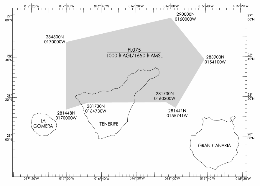](https://biblioteca.vatsimspain.es/uploads/images/gallery/2025-03/Dlrimage.png) ##### DELEGACIÓN ATS DE CANARIAS ACC A TENERIFE SUR APP Por acuerdo entre CANARIAS ACC y TENERIFE SUR APP, el servicio de tránsito aéreo lo proporcionará TENERIFE SUR APP en todo el espacio aéreo comprendido en el espacio aéreo sombreado en la imagen entre 1000ft AGL y FL105. [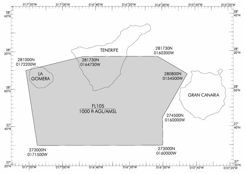](https://biblioteca.vatsimspain.es/uploads/images/gallery/2025-03/6gmimage.png) --- #### **SECTORIZACIÓN** ##### **NORTE BAJA** [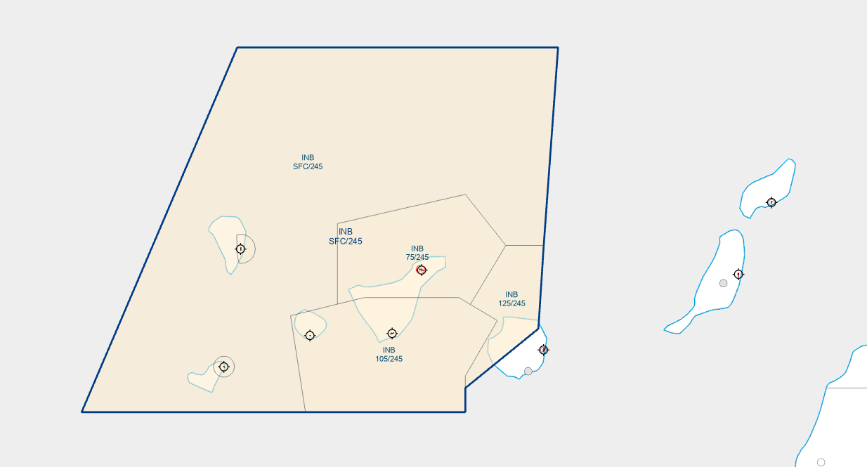](https://biblioteca.vatsimspain.es/uploads/images/gallery/2025-03/UPQimage.png) **POSICIONES**| **SECTOR** | **POSICIÓN** | **INDICATIVO** | **FRECUENCIA** | **NOTAS** |
| INB | GCCA\_INB\_APP | Canarias Approach | 126.100 | Asumirá GCTS APP y GCXO APP igual que el resto de dependencias en caso de que estas estén desconectadas. |
| **SECTOR** | **POSICIÓN** | **INDICATIVO** | **FRECUENCIA** | **NOTAS** |
| NBW | GCCA\_INB\_APP | Canarias Approach | 126.100 | Alimentador para tráficos a GCTS, GCXO y GCLA. |
| NBE | GCCA\_NBE\_APP | Canarias Approach | 133.675 | Asumirá GCXO APP y GCXO APP en caso de que estas estén desconectadas. |
| **GCCC NBW** | **GCCC NBE** |
| GCCA\_NBE\_APP | |
| GCCA\_INB\_APP | |
| **TRANSFERENCIAS EN SALIDA** | |||
| **Hacia** | **De** | **A** | **Autorizados nivel** |
| VASTO, DESUM, KORAL, RASEP | GCTS APP | GCCA APP (NBE) | FL240 |
| GCCA APP (NBW) | GCCC CTR (RES) | ||
| ODEGI, REMGI | GCTS APP | GCCA APP (NBE) | FL100 |
| GCCA APP (NBW) | GCCC CTR (RES) | FL240 | |
| PELIN, COSSE | GCTS APP | GCCA APP (NBE) | FL100 |
| MOROD, HIE | GCTS APP | GCCA APP (NBW) | FL100 |
| **TRANSFERENCIAS EN LLEGADA** | ||||||
| **Desde** | **De** | **A** | **Autorizados nivel** | |||
| TERTO, RUSIK, LORPO, REMGI, ESOPA | GCCA APP (NBE) | GCTS APP | FL110 | |||
| ORTIS, KNOBA, URQUI, HIE | GCCA APP (NBW) | GCTS APP | FL110 | |||
| ODEGI\*Y (RWY 25) | GCCA APP (NBW) | GCTS APP | FL110 | |||
| ODEGI\*Z (RWY 07) | GCCA APP (NBE) | GCTS APP | FL110 | |||
| **TRANSFERENCIAS EN SALIDAS** | |||
| **Hacia** | **De** | **A** | **Autorizados a Nivel ** |
| YEQAY, ARACO, HIE | GCXO APP | GCCA APP (NBW) | FL070 |
| BIMBO, KONBA, SAMAR | GCXO APP | GCCA APP (NBE) | FL070 |
| GCCA APP (NBE) | GCCC CTR (RW3) | FL240 | |
| VASTO, KORAL, LALTO, GDV, LPC | GCXO APP | GCCA APP (NBE) | FL070 |
| GCCA APP (NBE) | GCCC CTR (RES) | FL240 | |
| **TRANSFERENCIAS EN LLEGADA** | |||
| **Desde** | **De** | **A** | **Autorizados a nivel** |
| CANDE, RUSIK, SAMAR, TERTO | GCCA APP (NBE) | GCXO APP | FL080 |
| BOXCO, KONBA, ORTIS, HIE | GCCA APP (NBW) | GCXO APP | FL080 |
En **GCLA** la mayoría de llegadas por la pista 36 necesitan **regreso por pista**, por tanto en configuración norte es aún más crucial esta separación de **15NM**.
--- #### **INFORMACIÓN ADICIONAL**Si has encontrado información errónea en esta página o hay algo que crees que podrías mejorar, comunicalo por [email a operaciones](https://vatsimspain.es/staff).
**Log de versiones (ACCSP54)** 1558357 - Redacción inicial y adaptación al nuevo formato de la wiki. (17/01/24)
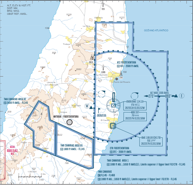
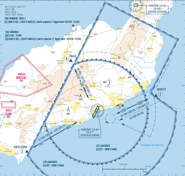
# Canarias Aproximación Este | TMA Canarias #### ORGANIZACIÓN DEL ESPACIO AÉREO [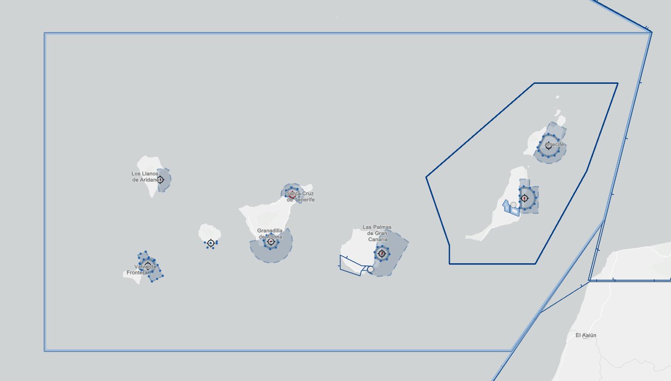](https://biblioteca.vatsimspain.es/uploads/images/gallery/2025-03/1eMimage.png) - **TMA Canarias:** El contorno azul que abarca el archipiélago canario. Cubre desde SFC a FL145. Se clasifica cómo **Clase D** desde 1000FT AGL o el límite superior de los FIZ/ATZ/CTR hasta **FL145. Clase C FL145-FL460.** - **CTR Fuerteventura:** El polígono sombreado azul sobre el este de Fuerteventura. Cubre desde SFC hasta 3500ft AMSL. **Clase D.** - **ATZ Fuerteventura:** Poligono incluido dentro del CTR sobre el este de Fuerteventura. Cubre desde SFC hasta 2500ft AMSL. **Clase D**. - **CTR Lanzarote:** El polígono sombreado azul sobre el este de Lanzarote. Cubre desde SFC hasta 3500ft AMSL. **Clase D**. - **ATZ Lanzarote:** Poligono incluido dentro del CTR sobre el este de Lanzarote. Cubre desde SFC hasta 2800ft AMSL. **Clase D**. --- #### **SECTORIZACIÓN** ##### **CANARIAS ESTE** [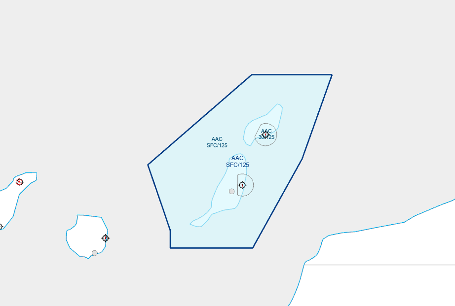](https://biblioteca.vatsimspain.es/uploads/images/gallery/2025-03/GDeimage.png) **POSICIONES**| **SECTOR** | **POSICIÓN** | **INDICATIVO** | **FRECUENCIA** | **NOTAS** |
| AAC | GCCA\_AAC\_APP | Canarias Approach | 129.300 | Asumirá GCFV y GCRR TWR en caso de que estas estén desconectadas. |
**PROCEDIMIENTO DE COMUNICACIÓN REDUCIDA (PCR)** **Llegadas**: en las transferencias de comunicaciones por parte de Canarias Control a Aproximación de Canarias, la llamada inicial se limitará al indicativo del vuelo para evitar congestionar la frecuencia (p. ej. "Aproximación + Binter 321"). **Salidas:** Para evitar congestionar la frecuencia en la transferencia de comunicaciones de tránsitos en despegue ya sea de GCFV TWR o GCRR TWR a Aproximación de Canarias, la llamada inicial será nombre de la dependencia a la que se llama e indicativo de la aeronave que llama (p. ej. Canarias, Binter 321, de GCRR/GCFV).
- Según certificación de la aeronave, el tránsito más habitual es el siguiente y está suelto siempre:| SALIDAS RNAV1/GNSS A | SAMAR, VASTO, DESUM, KORA, GCRR03 Y GCFV01 |
| SALIDAS RNAV1 DME/DME A | SAMAR Y VASTO, DESUM, PISTAS GCRR03 Y GCFV01 |
| CONVENCIONALES | INTERINSULARES |
| RNAV DME/DME INTERINSULAR | SALIDA CONVENCIONAL |
| RNAV DME/DME POR KORAL | SALIDA CONVENCIONAL |
| RNAV1 DME/DME GCRR21 y GCFV19 | A VASTO, SAMAR, DESUM SALIDA DE CONTIGENCIA Y VECTORES PARA INFORPORARLO A LA SALIDA. |
| SALIDAS A BIMBO | SALIDA SAMAR EN FUNCIÓN DE SU EQUIPAMIENTO Y COORDINAR CON CANARIAS PARA QUE CAMBIE LA RUTA, SI EL TRÁNSITO FUESE CONVENCIONAL COORDINAR LA SALIDA QUE NOS RESULTE MÁS APROPIADA Y VECTORES |
| Desde GCRR RWY 03 | GCFV RWY 01 | SOTAD XM |
| TENDA XM | ||
| GCFV RWY 19 | BAMKU XM | |
| KEMEV XM | ||
| Desde GCRR RWY 21 | GCFV RWY 01 | SOTAD XN |
| TENDA XN | ||
| GCFV RWY 19 | BAMKU XN | |
| KEMEV XN |
| **DESDE** | **HACIA** | **NIVEL** | **PROCEDIMIENTO** |
| GCCC | AAC | 130 | STAR de TERTO / DEVLA a GCRR y de TERTO / RUSIK a GCFV |
| ECL\* 120 o inferior | Sobrevuelos y entradas a aeropuertos canarios por debajo de FL130 |
| ENTRADAS RNAV1 / GNSS | TERTO, DEVLA, RUSIK |
| ENTRADAS CONVENCIONALES | INTERISLAS (MAPED, LUNOB, SIRPU Y KEMEV), DEVLA Y RUSIK. |
| RNAV1 DME/DME por TERTO | NOS LOS COORDINA GCCC directo a IAF GNSS POR EL ESTE (O UN VECTOR SI HAY PISTA NO HABITUAL). En el campo de RMK en EuroScope nos habrá puesto RUTA la leyenda RRNOG (para GCRR) o FVNOG (para GCFV) para indicar que el tránsito no posee capacidad GNSS. |
| CONVENCIONAL POR TERTO | AUTORIZACIÓN LÍMITE IAF MAPED/LTE, COORDINAR RUMBO CON AAC ESPERANDO VECTORES. |
| TRÁNSITO POR ORTIS | NOS LO COORDINADA GCCC DIRECTO AL IAF CONVENCIONAL POR EL OESTE |
Si has encontrado información errónea en esta página o hay algo que crees que podrías mejorar, comunícalo por [email a operaciones](https://vatsimspain.es/staff).
**Log de versiones (ACCSP54)** 1558357 - Redacción inicial y adaptación al nuevo formato de la wiki. (16/03/24). 1513609 - Creación del apartado "modo de operación" en procedimientos locales y "operación anti-ruido" (20/08/2025)
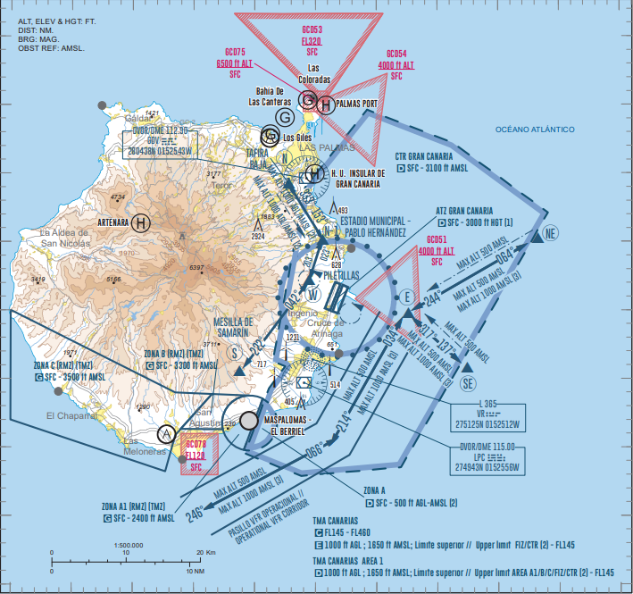
# Gran Canaria Aproximación | TMA Canarias #### **ORGANIZACIÓN DEL ESPACIO AÉREO** [](https://biblioteca.vatsimspain.es/uploads/images/gallery/2025-05/ppUimage.png) - **TMA Canarias AREA 1:** El contorno azul que abarca el archipiélago canario. Se clasifica cómo **Clase D** desde 1000FT AGL o el límite superior de los FIZ/ATZ/CTR hasta **FL145.** Por encima se encuentra el **TMA Canarias** que es **Clase C** desde **FL145** a **FL460 - **CTR Gran Canaria:** El polígono sombreado azul sobre Gran Canaria. Cubre desde SFC hasta 3100ft AMSL. **Clase D** - **ATZ Gran Canaria:** Circunferencia de 8km de radio centrada sobre el ARP. Cubre desde SFC hasta 3000ft HGT o la elevación del techo de nubes (lo que resulte más bajo). **Clase D** --- #### **SECTORIZACIÓN** ##### **GRAN CANARIA APROXIMACIÓN + FEEDER** [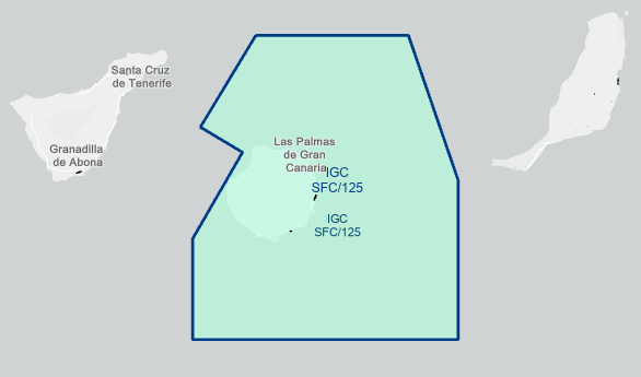](https://biblioteca.vatsimspain.es/uploads/images/gallery/2025-05/P02image.png) **POSICIONES**| **SECTOR** | **POSICIÓN** | **INDICATIVO** | **FRECUENCIA** |
| IGC | GCLP\_GCA\_APP | Gran Canaria Approach | 124.300 |
| **Configuración Norte** | **Configuración Sur** |
| [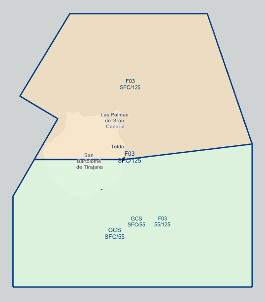](https://biblioteca.vatsimspain.es/uploads/images/gallery/2025-05/oGjimage.png) | [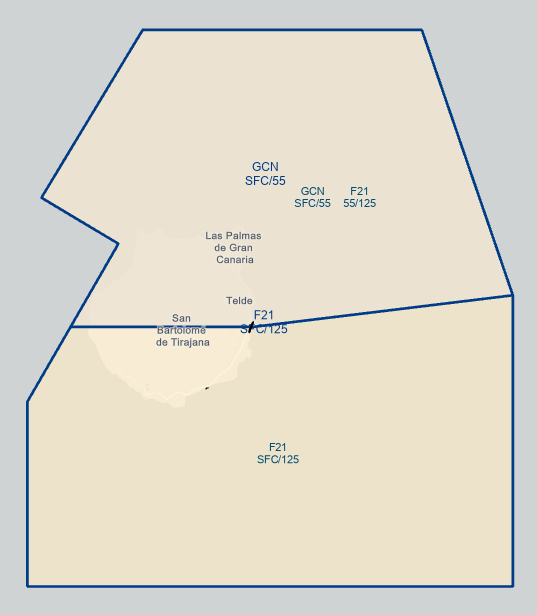](https://biblioteca.vatsimspain.es/uploads/images/gallery/2025-05/8kLimage.png) |
| **SECTOR** | **POSICIÓN** | **INDICATIVO** | **FRECUENCIA** | **NOTAS** |
| F03/F21 | GCLP\_GCA\_APP | Gran Canaria Approach | 124.300 | Secuencia inicialmente las arribadas a GCLP además de controlar las salidas |
| GCS/GCN | GCLP\_F\_APP | Gran Canaria Final | 121.300 | Aproximación final para GCLP. Encargado de proporcionar los vectores/directos finales y asegurar la correcta separación en el localizador |
| **Hacia** | **Nivel** | **Procedimiento** |
| RCE | 200 | SID GCLP RWY21 VASTO/SAMAR |
| 120 | SID GCLP RWY03 VASTO/SAMAR | |
| RNE | 200 | SID GCLP RWY21KORAL |
| 120 | SID GCLP RWY 03 | |
| 110 | SID GCLP vía COSTI | |
| RST | 120 | SID GCLP |
| AAC | ECL impar | |
| GCCA\_NBE\_APP | 80 | SID GCLP DESTINO GCLA/GCXO |
| 150 | SID GCLP RWY21 vía THAIS KONBA/BIMBO | |
| ECL par | SID GCLP destino GCHI y vía HIE | |
| 120 | SID GCLP RWY 03 vía THAIS KONBA/BIMBO | |
| GCTS\_APP | 100 o ECL par inferior | SID a GCTS y GCGM |
En caso de **distinta categoría de estela turbulenta** deberá cumplirse la separación radar más restrictiva establecida en el RCA 4.6.7.4.4
--- ##### **SEPARACIONES ESTÁNDAR EN LLEGADA**La separación estándar en llegada será de **6 NM en configuración Norte** y **8 NM en configuración Sur**
Las separaciones anteriormente mencionadas se incrementarán en **3 NM** en caso de operar con una **única pista** y/o en **2 NM** si **no se dispone de salida rápida**
Esta distancia ha de mantenerse hasta que el primer tráfico se encuentre a 4 NM del umbral de pista --- ##### **SEPARACIONES REDUCIDAS** En caso de **sobrecarga en el sector de aproximación**, este podrá solicitar a TWR la reducción de la separación entre llegadas sucesivas formando paquetes de tamaño determinado (**2 o 3 arribadas por despegue**, según convenga) durante un periodo a definir (tiempo o tráficos involucrados)Entre los tráficos de dichos paquetes se aplicará una separación de **4 NM en configuración Norte** y **8 NM en configuración Sur**
En caso de operar únicamente con la pista **03L y sin salida rápida**, las separaciones se incrementarán a **7 NM**; si se opera solo con la **03R y sin salida rápida**, se incrementarán a **8 NM**
**Ejemplo de fraseología entre APP y TWR** *Por saturación del sector de APP en los próximos xx minutos se solicita X arribadas por despegue con separación entre las arribadas de un mismo paquete de Y NM*En situaciones de baja demanda de despegues, TWR podría sugerir la aplicación de este procedimiento
**Ejemplo de fraseología entre TWR y APP** *En los próximos xx minutos todas las arribadas podrán ir con separación reducida de Y NM* --- ##### **SEPARACIONES AMPLIADAS** En caso de **sobrecarga en la plataforma o el punto de espera**, TWR podrá solicitar a APP la ampliación de la separación entre llegadas sucesivas para permitir varios despegues seguidos (**2 o 3 despegues por arribada**, según convenga) durante un periodo a definir (tiempo o tráficos involucrados)| Configuración | Pistas en uso | Nº de despegues sucesivos | Separación (NM) |
| Norte | Ambas | **2** | **12** |
| **3** | **17** | ||
| Una | **2** | **15** | |
| **3** | **20** | ||
| Sur | Ambas | **2** | **12** |
| **3** | **17** | ||
| Una | **2** | **16** | |
| **3** | **21** |
En **configuración sur** se asignarán vectores del tipo *viento en cola*, para posteriormente instruir directo al IF **TUPIX**
--- ##### **EL BERRIEL (GCLB)**La carta de acuerdo entre GCLB, GCLP y GCCC puede ser encontrada [**aquí**](https://drive.google.com/file/d/1_yCE7BFjpxfC0F9lcAeVvh2z9chmGjhn/view?pli=1).
El Berriel es un aeródromo **no controlado.** Los tráficos en **salida de GCLB** están exentos de enviar plan de vuelo y contactar con APP siempre y cuando se matengan en espacio aéreo no controlado, en caso contrario deberán contactar con APP antes de entrar en espacio aéreo controlado Se considera **espacio aéreo no controlado** lo siguiente: - Tráficos en circuito en GCLB - Tráficos fuera del CTR y por debajo de 1650 ft AMS o 1000 ft AGL (lo que resulte más alto) - Zonas A1, B y C[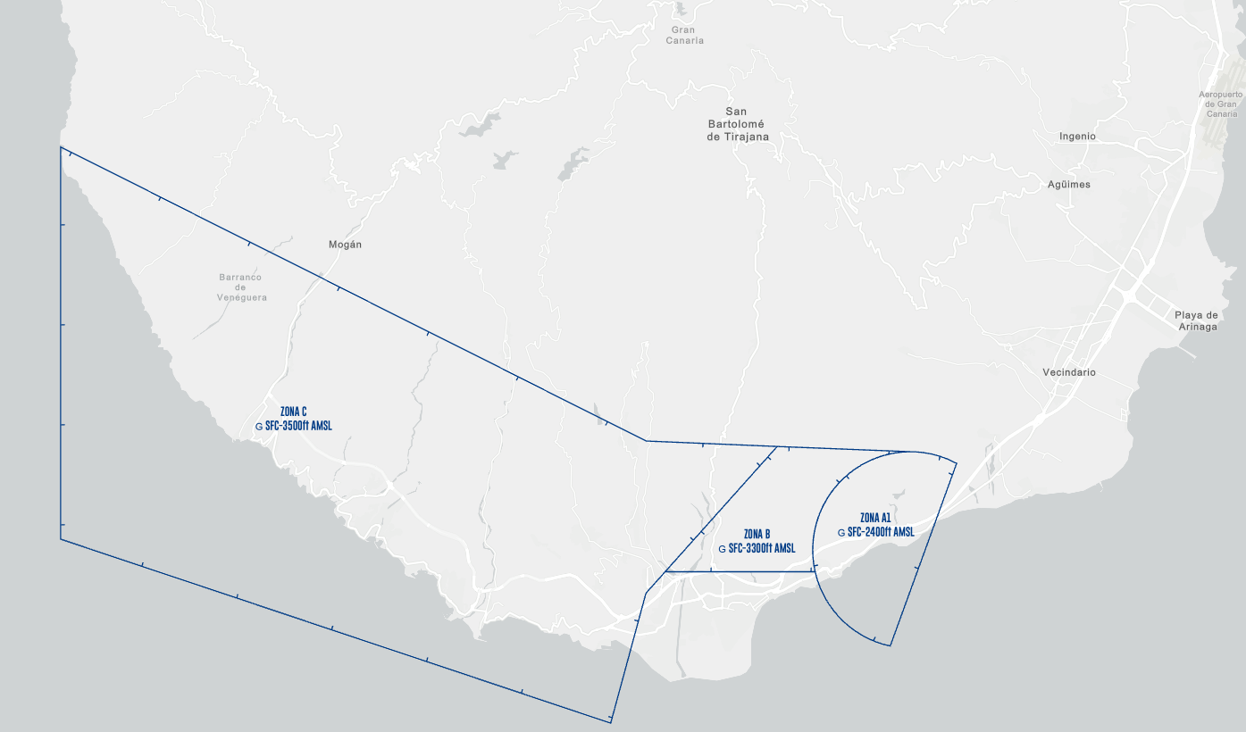](https://biblioteca.vatsimspain.es/uploads/images/gallery/2025-05/fU3image.png)
A los tráficos con **destino GCLB** se les pedirá que llamen en espacio aéreo no controlado o con toma asegurada en GCLB. Tras ello, serán transferidos a ADVISORY --- ### **PRACTICAR** **¿Quieres poner a prueba lo aprendido?** En los siguientes desplegables encontrarás un examen teórico para afianzar los conceptos, así como una sweatbox con la que podrás practicar por tu cuenta la gestión de múltiples llegadas a GCLP mediante el uso del procedimiento *Vector to Merge*Si has encontrado información errónea en esta página o hay algo que crees que se podría mejorar, comunícalo a operaciones a través de nuestra [página de contacto](https://vatsimspain.es/vacc/contacto/)
**Log de versiones** *(ACCSP54) 1558357* - Redacción inicial y adaptación al nuevo formato de la wiki (21/03/24) *(ACCSP2) 1495376* - Rediseño, ampliación, test de autoevaluación y sweatbox (27/05/25)
# Tenerife Sur Aproximación | GCTS #### ORGANIZACIÓN DEL ESPACIO AÉREO [](https://biblioteca.vatsimspain.es/uploads/images/gallery/2025-04/8ahimage.png) - **TMA Canarias:** El contorno azul que abarca el archipiélago canario. Cubre desde SFC a FL145. Se clasifica cómo **Clase D** desde 1000FT AGL o el límite superior de los FIZ/ATZ/CTR hasta **FL145. Clase C FL145-FL460. - **CTR Tenerife Sur:** El polígono sombreado azul sobre el sur de Tenerife. Cubre desde SFC hasta 1000ft AGL. Clase D. - **ATZ Tenerife Sur:** Circunferencia sobre el sur de Tenerife. Cubre desde SFC hasta 3000ft. Clase D. - **FIZ La Gomera:** Polígono sobre La Gomera. Cubre desde SFC hasta 1000ft AGL. Clase G. --- #### **SECTORIZACIÓN** ##### **TENERIFE SUR APP** [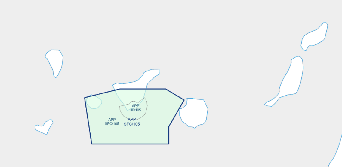](https://biblioteca.vatsimspain.es/uploads/images/gallery/2025-04/5acimage.png) **POSICIONES**| **SECTOR** | **POSICIÓN** | **INDICATIVO** | **FRECUENCIA** | **NOTAS** |
| GCTSAPP | GCTS\_APP | Tenerife Sur Approach | 127.700 | Asumirá [La Gomera Información (GCGM)](https://biblioteca.vatsimspain.es/books/fir-canarias-gccc/page/gcgm-la-gomera-afis) en caso de que esté desconectada. |
| SALIDAS RNAV1/GNSS A | Todas las publicadas. Salidas interinsulares por MOROD y HIE requieren coordinación entre TSAPP y GCTS TWR. |
| CONVENCIONALES | Salidas de contingencia destino GCXO (vía TFN, solicitar directo a BUNIX si configuración oeste en GCXO), GCLP (vía LPC, solicitar directo TOMOS en caso de configuración norte) |
| **DESDE** | **HACIA** | **NIVEL** | **PROCEDIMIENTO** |
| GCCC | TSAPP | 110 | STARS XO07 o XO25. |
| ECL\* 100 o inferior | Sobrevuelos y entradas a aeropuertos canarios por debajo de FL110 |
Si has encontrado información errónea en esta página o hay algo que crees que podrías mejorar, comunicalo por [email a operaciones](https://vatsimspain.es/staff).
**Log de versiones (ACCSP54)** 1558357 - Redacción inicial y adaptación al nuevo formato de la wiki. (07/04/24)
# Tenerife Norte Aproximación | GCXO #### ORGANIZACIÓN DEL ESPACIO AÉREO [](https://biblioteca.vatsimspain.es/uploads/images/gallery/2025-04/nsSimage.png) - **TMA Canarias:** El contorno azul que abarca el archipiélago canario. Cubre desde SFC a FL145. Se clasifica cómo **Clase D** desde 1000FT AGL o el límite superior de los FIZ/ATZ/CTR hasta **FL145. Clase C FL145-FL460. - **CTR Tenerife Norte:** El polígono sombreado azul sobre el norte de Tenerife. Cubre desde SFC hasta 4500ft AGL. Clase D. - **ATZ Tenerife Norte:** Poligono incluido dentro del CTR sobre el norte de Tenerife. Cubre desde SFC hasta 3000ft AGL. Clase D. --- #### **SECTORIZACIÓN** ##### **TENERIFE NORTE APP** [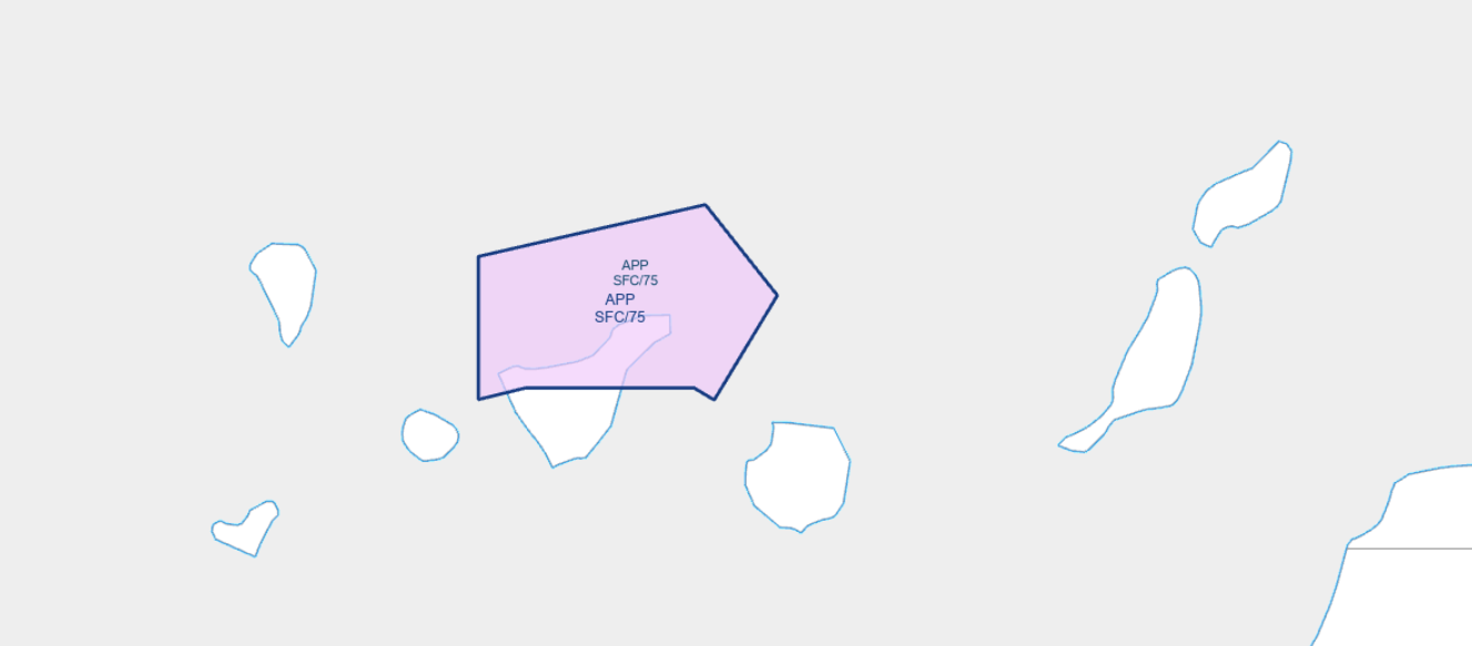](https://biblioteca.vatsimspain.es/uploads/images/gallery/2025-04/we7image.png) **POSICIONES**| **SECTOR** | **POSICIÓN** | **INDICATIVO** | **FRECUENCIA** | **NOTAS** |
| GCXOAPP | GCXO\_APP | Tenerife Norte Approach | 124.800 | - |
Si has encontrado información errónea en esta página o hay algo que crees que podrías mejorar, comunicalo por [email a operaciones](https://vatsimspain.es/staff).
**Log de versiones (ACCSP54)** 1558357 - Redacción inicial y adaptación al nuevo formato de la wiki. (07/04/24)
# Torres Documentación de las posiciones de TWR, GND y DEL de los aeropuertos de GCCC. # GCFV | Fuerteventura [TWR,GND]Existe un **suplemento** activo que afecta a **GCFV**. **Hasta el 16 de abril de 2027** estimado**, el DVOR/DME LPC estará fuera de servicio** por sustitución del sistema. **Procedimientos afectados::** SID RWY 01: **Salida LORPO4Q: salida no disponible.** SID RWY 19: **Salida LORPO4R: salida no disponible. Ref: [ENAIRE SUP 56/26](https://aip.enaire.es/aip/contenido_SUP/LE_SUP_A_2026_056_es.html)**
### **POSICIONES**| **LOGIN** | **DISTINTIVO DE LLAMADA** | **FRECUENCIA** |
| **GCFV\_ATIS** | **Fuerteventura Atis** | **118.650** |
| **GCFV\_GND** | **Fuerteventura Ground** | **121.700** |
| **GCFV\_TWR** | **Fuerteventura Tower** | **118.475** |
**Para estas posiciones recomendamos utilizar GCFV\_GND\_GR.asr.**
[](https://biblioteca.vatsimspain.es/uploads/images/gallery/2024-05/screenshot-2024-05-25-121433.png) ##### **GCFV\_TWR****Para esta posición recomendamos utilizar GCFV\_GND\_GR.asr junto a GCCC.asr y alternar mediante "F7".**
**Con el GCCC.asr seleccionado, debes dirigirte al display Settings dialog y seleccionar el TAG de SACTA TWR en el desplegable.**
[](https://biblioteca.vatsimspain.es/uploads/images/gallery/2024-05/wNqimage.png)**Para activar líneas de los estacionamientos y las de taxi en GCFV\_GND\_GR.asr , hay que seleccionarlas en FUNCTIONS -> MAPS-> GCCC.**
--- ### **REGLAMENTACIÓN LOCAL****La pista preferente para Fuerteventura es la 01.**
Los helicópteros serán tratados como aeronaves de ala fija.
Rodaje de los helicópteros: - Solo se permite: **E1 a E10, T1 a T8, L1, L5, A1.** - **B3** solo para helicópteros de la **Guardia Civil.**En los siguientes escenarios es recomendable (no obligatorio) el uso del idioma inglés cuando exista un piloto que no sea de habla castellana.
- Autorizaciones de aterrizaje con tráfico en el punto de espera. - Autorizaciones de despegue con tráfico en final. - Autorizaciones para entrar y mantener desde puntos de espera congestionados.Esto no aplica a los pilotos de habla castellana bajo reglas VFR.
--- ### **AUTORIZACIONES****La altitud de transición es 6000ft.**
#### **SALIDAS DE CONTINGENCIA**| **Pista** | **01** | **19** |
| **Procedimiento** | **Rumbo de pista y ascenso a 4000ft** | |
**GCFV dispone de DCL.**
#### **RETROCESOS**| **Pista** | **01** | **19** |
| **Dirección** | **Aproando sur** | **Aproando norte** |
**No se permiten retrocesos simultáneos en puestos adyacentes.**
**No se permite el retroceso desde un puesto con una aeronave entrando al puesto adyacente.**
--- ### **RODADURA** #### **PISTA 01** [](https://biblioteca.vatsimspain.es/uploads/images/gallery/2024-07/T50image.png) #### **PISTA 19** [](https://biblioteca.vatsimspain.es/uploads/images/gallery/2024-07/0cPimage.png) #### **GENERAL** - **TWY B3:** Sólo de rodaje aéreo para helicópteros de la Guardia Civil. - **TWY A4:** Limitada a aeronaves de letra de clave C o inferiores. - **TWY E2 y E9:** Limitada a aeronaves de letra de clave D o inferiores. - **TWY E3, E4, E6 a E8:** Solo para salir de la pista. - **TWY E5:** Solo para salir de la pista excepto helicópteros --- ### **TORRE** #### **SALIDAS**Se asumirá que el piloto está listo para salir cuando lleguen al punto de espera de la pista.
Estás separaciones aplican para ambas pistas.
| **Pista** | **Separación** |
| **Reactor detrás de reactor** | **8 NM** |
| **Reactor detrás de turbohélice** | **10 NM** |
| **Turbohélice detrás de turbohélice** | **8 NM** |
| **Turbohélice detrás de reactor** | **5 NM** |
| **Pistón detrás de pistón** | **8 NM** |
| **Pistón detrás de turbohélice o reactor** | **5 NM** |
Si hay un **reactor o un turbohélice detrás de un pistón** la separación la aplicará en cada caso la dependecia superior (CANARIAS ACC).
#### **LLEGADAS**| **Pista** | **01** | **19** |
| **Separación** | **8 NM** | **8 NM** |
Los **circuitos de tránsito** se pueden realizar por el **este** del campo.
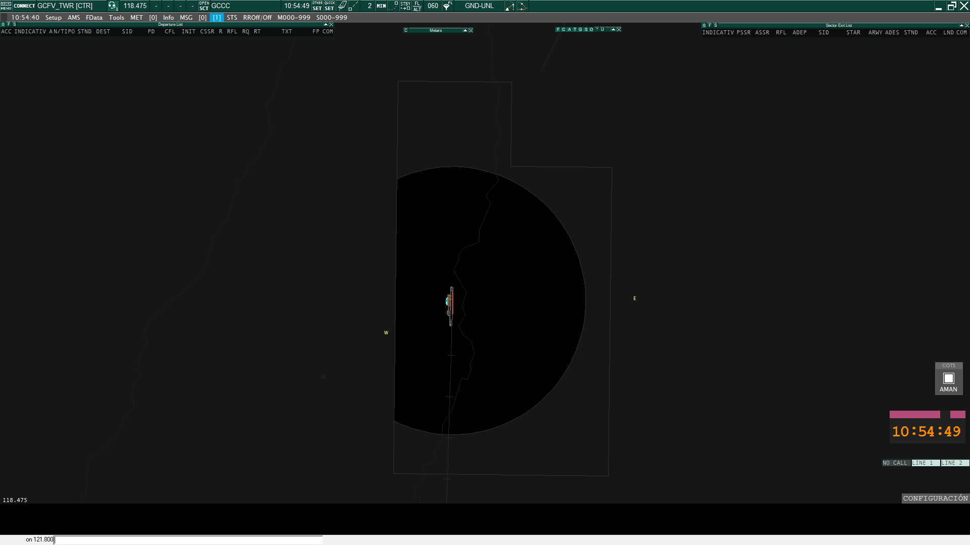
[](https://biblioteca.vatsimspain.es/uploads/images/gallery/2024-05/7s3image.png) #### **SALIDAS Y LLEGADAS**Las aeronaves VFR establecerán contacto con TWR antes de alcanzar los puntos **W** y **E.**
[](https://biblioteca.vatsimspain.es/uploads/images/gallery/2024-05/9oKimage.png) --- #### **INFORMACIÓN ADICIONAL**Si has encontrado información errónea en esta página o hay algo que crees que podrías mejorar, comunicalo por [email a operaciones](https://vatsimspain.es/staff).
# GCLA | La Palma [TWR,GND] ### **POSICIONES**| **LOGIN** | **DISTINTIVO DE LLAMADA** | **FRECUENCIA** |
| **GCLA\_ATIS** | **La Palma Atis** | **118.250** |
| **GCLA\_GND** | **La Palma Ground** | **121.800** |
| **GCLA\_TWR** | **La Palma Tower** | **118.900** |
**Para estas posiciones recomendamos utilizar GCLA\_GND\_GR.asr.**
[](https://biblioteca.vatsimspain.es/uploads/images/gallery/2024-05/lV1image.png) ##### **GCLA\_TWR****Para esta posición recomendamos utilizar GCLA\_GND\_GR.asr junto a GCCC.asr y alternar mediante "F7".**
**Con el GCCC.asr seleccionado, debes dirigirte al display Settings dialog y seleccionar el TAG de SACTA TWR en el desplegable.**
[](https://biblioteca.vatsimspain.es/uploads/images/gallery/2024-05/gXqimage.png)**Para activar líneas de los estacionamientos y las de taxi en GCLA\_GND\_GR.asr , hay que seleccionarlas en FUNCTIONS -> MAPS-> GCCC.**
--- ### **REGLAMENTACIÓN LOCAL****La pista preferente para La Palma es la 36.**
- Esta se empleará cuando el viento de cola no supere los 10kt y/o cruzado no supere los 25kt.Los helicópteros serán tratados como aeronaves de ala fija.
Las salidas y llegadas de los helicópteros se realizaran por la pista 18/36.
En los siguientes escenarios es recomendable (no obligatorio) el uso del idioma inglés cuando exista un piloto que no sea de habla castellana.
- Autorizaciones de aterrizaje con tráfico en el punto de espera. - Autorizaciones de despegue con tráfico en final. - Autorizaciones para entrar y mantener desde puntos de espera congestionados.Esto no aplica a los pilotos de habla castellana bajo reglas VFR.
--- ### **AUTORIZACIONES****La altitud de transición es 6000ft.**
#### **SALIDAS DE CONTINGENCIA** **No existen salidas de contingencia en este aeropuerto. Solo existe el siguiente procedimiento:** En caso de no poder cumplir con la pendiente mínima de ascenso, a petición del piloto se le indicará virar a la derecha en circuito de aeródromo, **condiciones visuales (VMC)**, para seguir rumbo magnético 094º, para seguir ruta magnética 055º NDB BX directo a VANUR, para integrarse en el correspondiente procedimiento de salida. Prohibido el viraje antes del extremo de salida de la pista (DER). - Para tráfico VFR, tenemos que asignarles el squawk de manera manual. Los squawks de los VFR empiezan en 7001. #### **RETROCESOS**| **Pista** | **18** | **36** |
| **Dirección** | **Aproando norte** | **Aproando sur** |
**No se permiten retrocesos simultáneos en puestos adyacentes.**
**No se permite el retroceso desde un puesto con una aeronave entrando al puesto adyacente.**
--- ### **RODADURA** #### **PISTA 18** [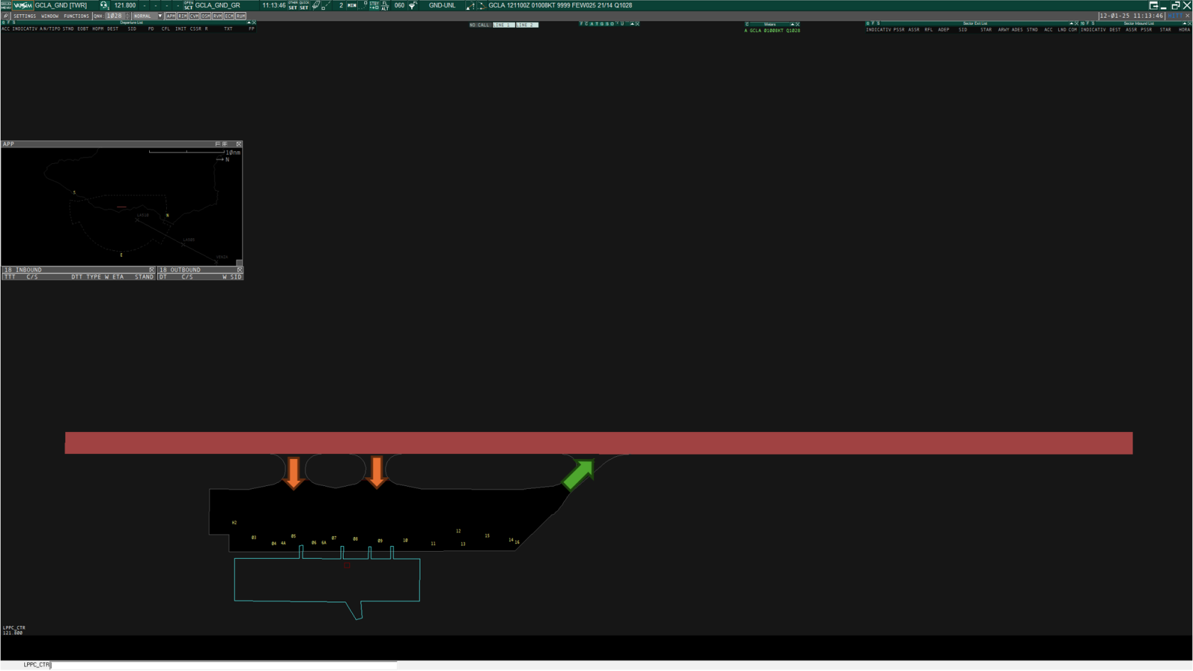](https://biblioteca.vatsimspain.es/uploads/images/gallery/2025-01/bSCimage.png) #### **PISTA 36** [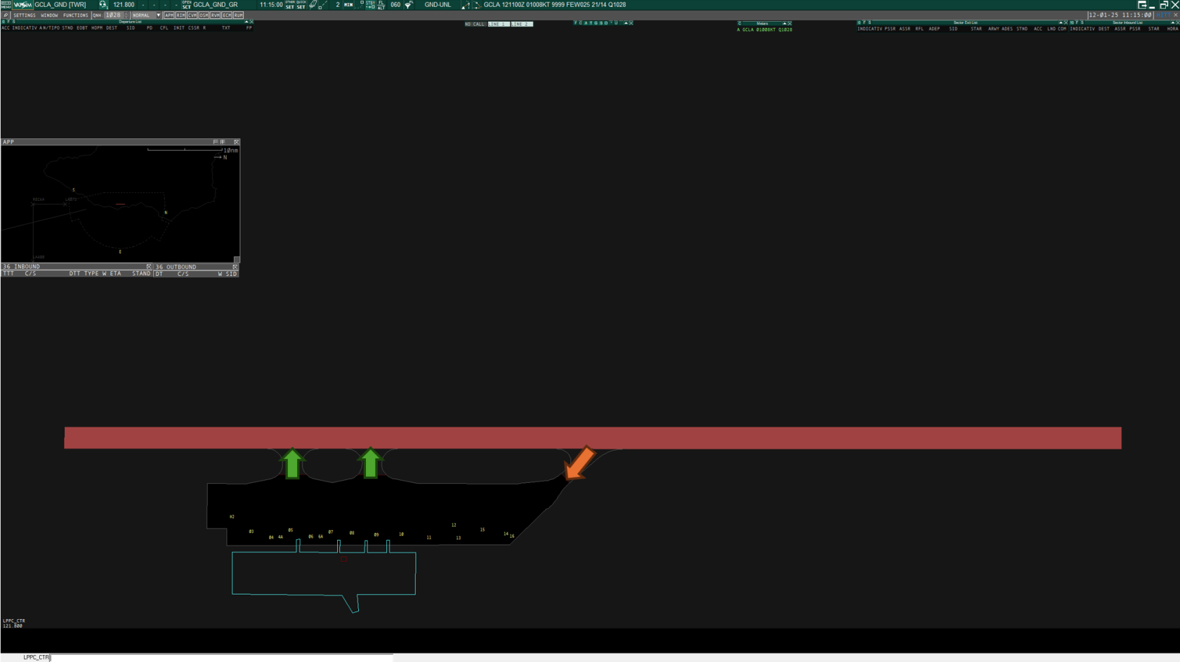](https://biblioteca.vatsimspain.es/uploads/images/gallery/2025-01/9XPimage.png) #### **GENERAL** Para aeronaves de letra de clave **D**: - PRKG 09 - PRKG 12 - PRKG 15 - PRKG 16 Para aeronaves de letra de clave **E**: - PRKG 4A - PRKG 6A - PRKG 11 - PRKG 14 #### **Helicópteros** No existen restricciones de rodaje en los helicópteros, eston realizarán un rodaje aereo o en tierra dependiendo del tipo de helicóptero. Los helicopteros estacionaran en: - PRKG H2 - PRKG 11 - PRKG 13 - PRKG 15 - PRKG 16 --- ### **TORRE** #### **SALIDAS****Todas las salidas están sujetas.** Para cada salida se necesita coordinar previamente con una dependecia superior.
#### **LLEGADAS**| **Pista** | **18** | **36** |
| **Separación** | **15 NM** | **15 NM** |
Los **circuitos de tránsito** se pueden realizar por el **sur** del campo.
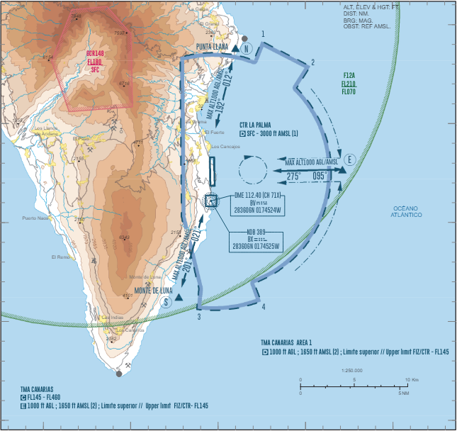
[](https://biblioteca.vatsimspain.es/uploads/images/gallery/2024-05/WrBimage.png) #### **SALIDAS Y LLEGADAS**Las aeronaves VFR establecerán contacto con TWR antes de alcanzar los puntos **E**, **N** (Punta Llana) o **S** (Monte de Luna).
[](https://biblioteca.vatsimspain.es/uploads/images/gallery/2024-05/6inimage.png) --- #### **INFORMACIÓN ADICIONAL**Si has encontrado información errónea en esta página o hay algo que crees que podrías mejorar, comunicalo por [email a operaciones](https://vatsimspain.es/staff).
# GCLP | Gran Canaria [TWR,GND,DEL]Existe un suplemento activo que afecta a GCLP. **Hasta el 16 de abril de 2027** estimado**, el DVOR/DME LPC estará fuera de servicio** por sustitución del sistema. **Procedimientos afectados:: SID** 2 RWY **21L/21R**: **Todas las salidas inutilizables.** Disponibles salidas de contingencia. **STAR** 1 RWY **03L/03R**: - Llegada **LORPO2C**. Navegación (DME/DME) no utilizable. GNSS requerido. - Llegada **SAMAR6C**. Navegación (DME/DME) no utilizable. GNSS requerido. - Espera **ENETA**. Navegación (DME/DME) no utilizable. GNSS requerido. - Espera **TOMOS**. Navegación (DME/DME) no utilizable. (DME/DME/IRU) o GNSS .requerido. **STAR** 2 RWY **21L/21R**: - Llegada **LORPO1D**. Navegación (DME/DME) no utilizable. GNSS requerido. - Llegada **RUSIK3D**. Navegación (DME/DME) no utilizable. GNSS requerido. - Espera **ENETA**. Navegación (DME/DME) no utilizable. GNSS requerido. **Aproximaciones IAC**: - IAC 3 **ILS X RWY 03L**: maniobra no disponible. - IAC 6 **LOC X RWY 03L**: maniobra no disponible. - IAC 7 **VOR RWY 03L**: maniobra no disponible. - IAC 13 **ILS Y RWY 21R**: maniobra no disponible. - IAC 15 **LOC Y RWY 21R**: maniobra no disponible. - IAC 16 **VOR RWY 21R**: maniobra no disponible. **Ref: [ENAIRE SUP 56/26](https://aip.enaire.es/aip/contenido_SUP/LE_SUP_A_2026_056_es.html)**
## **GCLP**Más información en: **[AIP Enaire - GCLP.](https://aip.enaire.es/AIP/AIP-en.html#GCLP "AIP Enaire - GCLP")**
### **POSICIONES**| **LOGIN** | **DISTINTIVO DE LLAMADA** | **FRECUENCIA** |
| **GCLP\_ATIS** | **Gran Canaria Atis** | **118.600** |
| **GCLP\_DEL** | **Gran Canaria Delivery** | **125.000** |
| **GCLP\_GND** | **Gran Canaria Ground** | **121.700** |
| **GCLP\_TWR** | **Gran Canaria Tower** | **118.300** |
Más información sobre el espacio aéreo en: **[AIP - Datos de aerodromo GCLP.](https://aip.enaire.es/AIP/contenido_AIP/AD/AD2/GCLP/LE_AD_2_GCLP_en.pdf ""Datos de aerodromo GCLP"")**
--- ### **CONFIGURACIÓN EN EUROSCOPE** ##### **GCLP\_DEL y GCLP\_GND****Para estas posiciones recomendamos utilizar GCLP\_GND\_GR.asr.**
[](https://biblioteca.vatsimspain.es/uploads/images/gallery/2024-05/Jvyimage.png) ##### **GCLP\_TWR****Para esta posición recomendamos utilizar GCLP\_GND\_GR.asr junto a GCCC.asr y alternar mediante "F7".**
**Con el GCCC.asr seleccionado, debes dirigirte al display Settings dialog y seleccionar el TAG de SACTA TWR en el desplegable.**
[](https://biblioteca.vatsimspain.es/uploads/images/gallery/2024-05/f4Iimage.png)**Para activar líneas de los estacionamientos y las de taxi en GCLP\_GND\_GR.asr , hay que seleccionarlas en FUNCTIONS -> MAPS-> GCCC.**
--- ### **REGLAMENTACIÓN LOCAL****La configuración preferente para GCLP es "Norte Dual" (Salidas 03R / Llegadas 03L).**
Los despegues desde intersección **no** están disponibles en GCLP. **HELICÓPTEROS**Los helicópteros serán tratados cómo aeronaves de ala fija.
El FATO (Final Approach and Take-Off area) para helicópteros civiles siempre son por la pista 03L/21R, es decir: **Configuración norte:** FATO entre THR pista 03L y el ARP, usando R1 o S1 para entrar y S2 para salir de la pista. **Configuración sur:** FATO entre THR pista 21R y el ARP, usando R9L/R o S2 para entrar y S1 para salir de la pista **PARKINGS:** **LH01-LH04** via **R10** #### IDIOMAS:En los siguientes escenarios es recomendable (no obligatorio) el uso del idioma inglés cuando exista un piloto que no sea de habla castellana.
- Autorizaciones de aterrizaje con tráfico en el punto de espera. - Autorizaciones de despegue con tráfico en final. - Autorizaciones para entrar y mantener desde puntos de espera congestionados.Esto no aplica a los pilotos de habla castellana bajo reglas VFR.
Más información sobre la reglamentación local en: **[AIP - Datos de aerodromo GCLP.](https://aip.enaire.es/AIP/contenido_AIP/AD/AD2/GCLP/LE_AD_2_GCLP_en.pdf ""Datos de aerodromo GCLP"")**
--- ### **AUTORIZACIONES****La altitud de transición es 6000ft.**
#### **SALIDAS DE CONTINGENCIA**| **Pista** | **03L/R** | **21L/R** |
| **Procedimiento** | **Rumbo pista y ascenso a 4000ft, posterior instrucciones ATC.** | **Rumbo 190 grados y ascenso a 5000ft, posterior instrucciones ATC.** |
**GCLP dispone de DCL.**
Más información sobre las salidas en el AIP: [AIP - Cartas GCLP SID 03L/R](https://aip.enaire.es/AIP/contenido_AIP/AD/AD2/GCLP/LE_AD_2_GCLP_SID_1_en.pdf) [AIP - Cartas GCLP SID 21L/R](https://aip.enaire.es/AIP/contenido_AIP/AD/AD2/GCLP/LE_AD_2_GCLP_SID_2_en.pdf) #### **RETROCESOS**| **Pista** | **03L/R** | **21L/R** |
| **Dirección** | Aprobando sur exepto los stands remotos | Aprobando norte exepto los stands remotos |
**Independientemente de la pista en servicio, las aeronaves estacionadas en:**
- **N01, N02, N11, N12** siempre aproará hacia sur.**No se permiten retrocesos simultáneos en puestos adyacentes.**
**No se permite el retroceso desde un puesto con una aeronave entrando al puesto adyacente.**
Más información sobre los parkings y retrocesos: **[AIP - Cartas PDC GCLP](https://aip.enaire.es/AIP/contenido_AIP/AD/AD2/GCLP/LE_AD_2_GCLP_PDC_1_en.pdf).**
--- ### **RODADURA** En GCLP hay **rutas de rodaje estándar** disponibles que se pueden usar. Nota: las rutas de rodaje de las llegadas de la pista 03L/R están divididas en "aeronaves clave C o inferior" y "aeronaves clase D o superior". #### **PISTA 03L/R** ##### Salidas [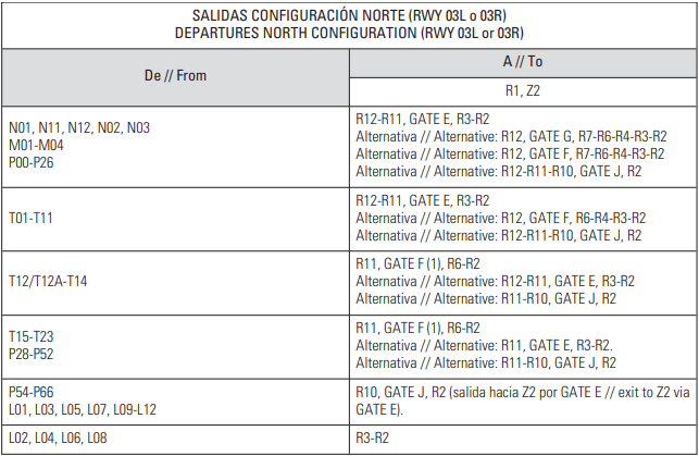](https://biblioteca.vatsimspain.es/uploads/images/gallery/2025-01/b5612508-02d8-46eb-bc99-f0074d071006.png) Llegadas [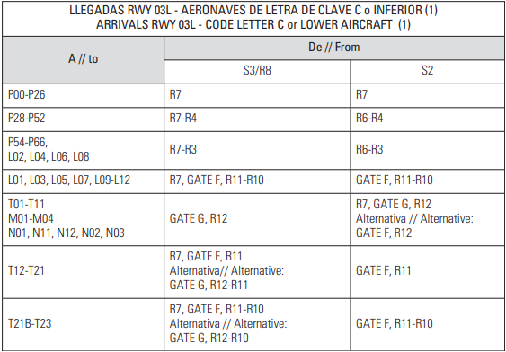](https://biblioteca.vatsimspain.es/uploads/images/gallery/2025-01/cd1f62b5-290d-4f23-82d9-fd34783c7cdc.png) [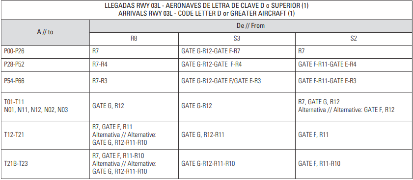](https://biblioteca.vatsimspain.es/uploads/images/gallery/2025-01/e2e7d81a-1db0-412b-a568-275bdabfa9a7.png) #### **PISTA 21L/R** ##### Salidas: [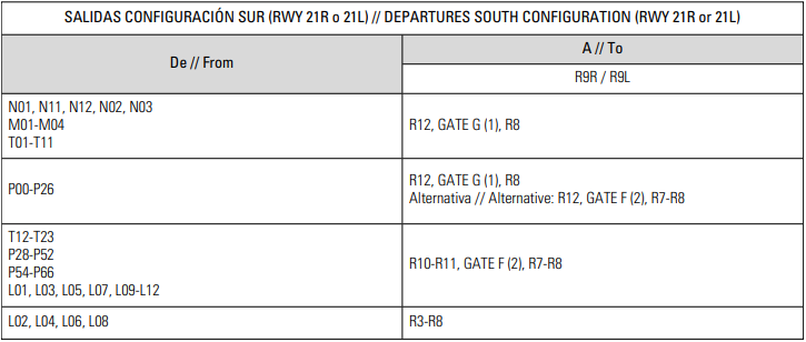](https://biblioteca.vatsimspain.es/uploads/images/gallery/2025-01/6e140cf4-0d1d-41a4-a1d7-d695fe2fa4f5.png) ##### Llegadas: [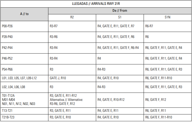](https://biblioteca.vatsimspain.es/uploads/images/gallery/2025-01/0fa3c2e3-5794-4144-9bb3-59877aea890f.png)Más información sobre la reglamentación local y rodadura en: **[AIP - Datos de aerodromo GCLP](https://aip.enaire.es/AIP/contenido_AIP/AD/AD2/GCLP/LE_AD_2_GCLP_en.pdf ""Datos de aerodromo GCLP"") y [AIP - Cartas GCLP GMC.](https://aip.enaire.es/AIP/contenido_AIP/AD/AD2/GCLP/LE_AD_2_GCLP_GMC_en.pdf)**
--- ### **TORRE** #### **Despegues** Los despegues están divididos por performance, entonces hay 3 posibilidades: 1. Aeronave precedente con performance superior a la siguiente. 2. Aeronave precedente con mismo performance a la siguiente. 3. Aeronave precedente con inferior performance a la siguiente.Las procidimientos difieren bastante según la configuración.
##### **Despegues pista 03L/R** **Resumen:**| **Superior Performance** | **Mismo Performance** | **Inferior Performance** |
| **3NM o 1,5 minutos** | **Mínimo 5NM o 2,5 minutos** | **Sujetas** |
| TFN + ARACO |
| KOPUD |
| RASEP + KORAL |
| VASTO + SAMAR + KONBA + BIMBO + SARAY |
| COSTI + ODEGI + REMGI + HIE + LOMAS + MOVAS |
| Viraje 1 | TFN + ARACO + COSTI + REMGI + ODEGI + HIE + LOMAS + MOVAS |
| Viraje 2 | KOPUD |
| Viraje 3 | RASEP + KORAL |
| Viraje 4 | VASTO + SAMAR + KONBA + BIMBO + SARAY |
En la próxima tabla hay todas las combinaciones de las salidas para las pistas 03L/R.
| **SID aeronave precedente** | **SID aeronave siguiente** | ||
| ARACO TFN | - | BIMBO COSTI HIE KONBA KOPUD KORAL LOMAS MOVAS ODEGI RASEP REMGI SAMAR SARAY VASTO | ARACO TFN |
| BIMBO KONBA SAMAR SARAY VASTO | ARACO COSTI HIE KOPUD KORAL LOMAS MOVAS ODEGI RASEP REMGI TFN | - | BIMBO KONBA SAMAR SARAY VASTO |
| COSTI HIE LOMAS MOVAS ODEGI REMGI | - | ARACO BIMBO KONBA KOPUD KORAL RASEP SAMAR SARAY TFN VASTO | COSTI HIE LOMAS MOVAS ODEGI REMGI |
| KOPUD | ARACO COSTI HIE LOMAS MOVAS ODEGI REMGI TFN | BIMBO KONBA RASEP SAMAR SARAY VASTO | KOPUD |
| KORAL RASEP | ARACO COSTI HIE KOPUD LOMAS MOVAS ODEGI REMGI TFN | BIMBO KONBA SAMAR SARAY VASTO | KORAL RASEP |
| Spearación | **3NM o 1,5 minutos** | **4NM o 2 minutos** | **5NM o 2,5 minutos** |
| **Superior Performance** | **Mismo Performance** | **Inferior Performance** |
| **3NM o 1,5 minutos** | **Mínimo 5NM o 2,5 minutos** | **Sujetas ** |
| TFN + ARACO + KORAL + RASEP + KONBA + BIMBO + VASTO + SAMAR + SARAY + COSTI + KOPUD |
| REMGI |
| ODEGI + HIE + LOMAS + MOVAS |
| Viraje 1 | ARACO + TFN + KORAL + RASEP + KONBA + BIMBO + VASTO + SAMAR + SARAY + COSTI + KOPUD |
| Viraje 2 | REMGI |
| Viraje 3 | ODEGI + HIE + LOMAS + MOVAS |
En la próxima tabla hay todas las combinaciones de las salidas para las pistas 21L/R.
| **SID aeronave precedente** | **SID aeronave siguiente** | ||
| ARACO BIMBO COSTI KONBA KOPUD KORAL RASEP SAMAR SARAY TFN VASTO | - | HIE LOMAS MOVAS ODEGI REMGI | ARACO BIMBO COSTI KONBA KOPUD KORAL RASEP SAMAR SARAY TFN VASTO |
| REMGI | ARACO BIMBO COSTI KONBA KOPUD KORAL RASEP SAMAR SARAY TFN VASTO | HIE LOMAS MOVAS ODEGI | REMGI |
| HIE LOMAS MOVAS ODEGI | ARACO BIMBO COSTI KONBA KOPUD KORAL RASEP REMGI SAMAR SARAY TFN VASTO | - | HIE LOMAS MOVAS ODEGI |
| **3NM o 1,5 minutos** | **4NM o 2 minutos** | **5NM o 2,5 minutos** | |
| **03L/R** | **21L/R** |
| [AIP - Cartas SID 03L/R](https://aip.enaire.es/AIP/contenido_AIP/AD/AD2/GCLP/LE_AD_2_GCLP_SID_1_en.pdf) [AIP - Cartas STAR 03L/R](https://aip.enaire.es/AIP/contenido_AIP/AD/AD2/GCLP/LE_AD_2_GCLP_STAR_1_en.pdf) [AIP - Cartas ILS Z 03L](https://aip.enaire.es/AIP/contenido_AIP/AD/AD2/GCLP/LE_AD_2_GCLP_IAC_1_en.pdf) | [AIP - Cartas SID 21L/R](https://aip.enaire.es/AIP/contenido_AIP/AD/AD2/GCLP/LE_AD_2_GCLP_SID_2_en.pdf) [AIP - Cartas STAR 21L/R](https://aip.enaire.es/AIP/contenido_AIP/AD/AD2/GCLP/LE_AD_2_GCLP_STAR_2_en.pdf) [AIP - Cartas ILS Z 21R](https://aip.enaire.es/AIP/contenido_AIP/AD/AD2/GCLP/LE_AD_2_GCLP_IAC_12_en.pdf) |
Todas las cartas disponible en: **[AIP - GCLP.](https://aip.enaire.es/AIP/AIP-en.html#GCLP)**
##### **Timpo mínimo de ocupación de pista (MROT) - Salidas** En caso de que un tráfico que vaya a despegar por RWY 21L requiera rodar hasta sobrepasar el cable de frenado fijo de dicha pista (GCLP-02-C-B), lo notificará a ATC en la solicitud de autorización ATC y, en cualquier caso, antes de comenzar el rodaje. La posición del cable de frenado fijo de RWY 21L (GCLP-02-C-B) y la distancia declarada para la operación desde dicho punto vienen recogidas en las casillas 20 y 13 respectivamente. Ver en [AIP AD\_2\_GCLP](https://aip.enaire.es/AIP/contenido_AIP/AD/AD2/GCLP/LE_AD_2_GCLP_en.pdf). #### **Llegadas**| **Configuración de pistas** | **Separación** |
| 03L ARR + 03R DEP (dual runway) | 6NM |
| 03L o 03R (single runway) | 9NM |
| 21L DEP + 21R ARR (dual runway) | 8NM |
| 21L o 21R (single runway) | 11NM |
Los **circuitos de tránsito** se pueden realizar por el **este** del campo.
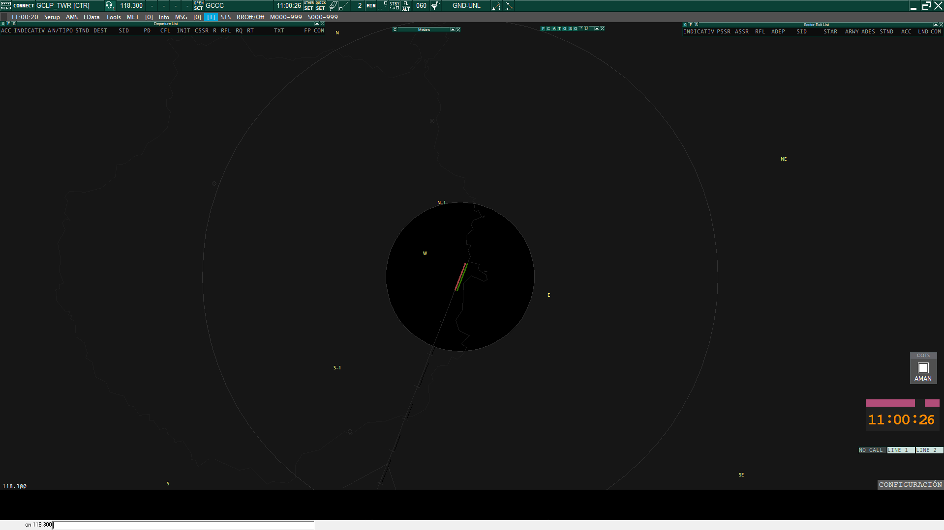
[](https://biblioteca.vatsimspain.es/uploads/images/gallery/2024-05/YRSimage.png) #### **SALIDAS Y LLEGADAS**Las aeronaves VFR establecerán contacto con APP antes de alcanzar los puntos **NE**, **SE**, **S** y **N.**
Las aeronaves VFR establecerán contacto con TWR antes de alcanzar los puntos **N-1, E** y **W**.
[](https://biblioteca.vatsimspain.es/uploads/images/gallery/2025-01/ca80d844-c4a8-4c82-acb7-095149ea25f6.png)Ruta **norte: W, N, N-1** en ambos sentidos.
Ruta **sur: W, S, S-1** en ambos sentidos.
Ruta **este: NE/SE**, **E.**
Más información sobre los tráficos VFRs en el AIP: **[AIP - VAC GCLP.](https://aip.enaire.es/AIP/contenido_AIP/AD/AD2/GCLP/LE_AD_2_GCLP_VAC_1_en.pdf ""Datos de aerodromo GCLP"")**
--- #### **INFORMACIÓN ADICIONAL**Si has encontrado información errónea en esta página o hay algo que crees que podrías mejorar, comunicalo por [email a operaciones](https://vatsimspain.es/vacc/staff/).
Cambios: **ACCSP54 (1558357)** - Añadida la sección de MROT. (18/10/2025)
# GCRR | Lanzarote [TWR,GND]**Existe un suplemento activo que afecta a GCRR. Hasta el 16 de abril de 2027 estimado, el DVOR/DME LPC estará fuera de servicio por sustitución del sistema. Procedimientos afectados: **STAR 3 RWY 21: - Llegada RASEP2Q: marcaciones LPC de MAPED y LUNOB no disponibles. - Llegada LARYS2X: marcaciones LPC de MOTID y LUNOB no disponibles. Ref: [ENAIRE SUP 56/26](https://aip.enaire.es/aip/contenido_SUP/LE_SUP_A_2026_056_es.html)
### **POSICIONES**| **LOGIN** | **DISTINTIVO DE LLAMADA** | **FRECUENCIA** |
| **GCRR\_ATIS** | **Lanzarote Atis** | **118.625** |
| **GCRR\_DEL** | **Lanzarote Ground** | **121.800** |
| **GCRR\_GND** | **Lanzarote Tower** | **120.700** |
**Para estas posiciones recomendamos utilizar GCRR\_GND\_GR.asr.**
[](https://biblioteca.vatsimspain.es/uploads/images/gallery/2024-05/XS8image.png) ##### **GCRR\_TWR****Para esta posición recomendamos utilizar GCRR\_GND\_GR.asr junto a GCCC.asr y alternar mediante "F7".**
**Con el GCCC.asr seleccionado, debes dirigirte al display Settings dialog y seleccionar el TAG de SACTA TWR en el desplegable.**
[](https://biblioteca.vatsimspain.es/uploads/images/gallery/2024-05/screenshot-2024-05-25-131034.png)**Para activar líneas de los estacionamientos y las de taxi en GCRR\_GND\_GR.asr , hay que seleccionarlas en FUNCTIONS -> MAPS-> GCCC.**
--- ### **REGLAMENTACIÓN LOCAL****El aereopuerto no dispone de pista preferente.**
**Los despegues desde intersección no están autorizados**, salvo desde EM para helicópteros.
**Limitaciones de Rodaje:** - Rodaje entre la **puerta A y B / B y C** está **prohibido** para aeronaves con **envergadura superior a 52 metros.** - Rodaje por la **puerta B** está **prohibido** para aeronaves con **envergadura superior a 50 metros.** - Acceso a la **plataforma de aviación general** queda **prohibido** para aeronaves con **envergadura superior a 15 metros.** - Tras aterrizar en la pista y **salir** por la calle **E2 y E3** las aeronaves **rodarán sin pararse hasta la TWY R.** - Aeronaves con **distancia entre ejes igual o superior a 18 metros** (B737 MAX 10 o superior) **no pueden utilizar la TWY EM.** **Rutas de Rodaje Estandarizadas:** - Con la **pista 03** las **aeronaves ATR** entrarán por la **puerta A.** - Con la **pista 21** las **aeronaves ATR** entrarán por la **puerta B.** **Aeronaves 4E:** - Se permite hasta la **aeronave 747-400.** - Las aeronaves 4E están limitadas a los **estacionamientos T1, T7 y 14.** **Movimientos de las aeronaves 4E:** **a) Llegadas:** - Con la **pista 03**, salida por la **TWY E2 o E1.** - Con la **pista 21**, salida por la **TWY E4.** En ambos casos rodaje por **TWY R** hasta la **puerta C** en caso de los **PRKG T1 o T7** o hasta la **puerta A** en caso del **PRKG 14.** **b) Salidas:** - Salida por **puerta C** en caso de los **PRKG T1 o T7.** - Salida por **puerta A** en caso del **PRKG 14.** **Restricciones:** - La **TWY EM** está **prohibida** para aeronaves de **clave E.** - Los **apartaderos de espera no están permitidos** para aeronaves de **clave E.** - **No está permitido el rodaje de las aeronaves de clave E por la plataforma interior.** ##### **HELICOPTEROS**Los helicópteros serán tratados como aeronaves de ala fija.
**Información General:** - Los helicópteros **despegaran y aterrizarán** por las **pistas** de vuelo. - Los rodajes se realizarán por las **calles de rodaje** destinadas a **aeronaves de ala fija.** **Estacionamientos disponibles:** - PRKG 15, 16, 19 y 24 **Llegadas:** - Se realizará el rodaje por la calle **exterior R.** - El acceso al **PRKG 24** se realizará por la **puerta C.** - **No** se realizarán **rodajes** por la plataforma **interior.** **Salidas:** - Con la **RWY 03** en uso: - Se realizará la rodadura a **E1 para el acceso a pista** y posteriormente se posicionará en **THR 21 para el despegue.** - Se realizará rodadura a **E4 para el despegue.** - Con la **RWY 21** en uso: - Se realizará la rodadura a **E4 para el acceso a pista** y posteriormente se posicionara en el **umbral de la pista 03 para el despegue por la pista 21.** - Se realizará la rodadura a **E1 para el despegue.** - Se **minimizarán** los **rodajes** por la **plataforma interior.** - El acceso al **PRKG 24** se realizará por la **puerta C**En los siguientes escenarios es recomendable (no obligatorio) el uso del idioma inglés cuando exista un piloto que no sea de habla castellana.
- Autorizaciones de aterrizaje con tráfico en el punto de espera. - Autorizaciones de despegue con tráfico en final. - Autorizaciones para entrar y mantener desde puntos de espera congestionados.Esto no aplica a los pilotos de habla castellana bajo reglas VFR.
--- ### **AUTORIZACIONES****La altitud de transición es 6000ft.**
#### **SALIDAS DE CONTINGENCIA**| **Pista** | **03** | **21** |
| **Procedimiento** | **Rumbo 047 y ascenso a 4000ft** | **Rumbo de pista y ascenso a 4000ft** |
**LEIB dispone de DCL.**
#### **RETROCESOS**| **Pista** | **03** | **21** |
| **Dirección** | **Aproando sur** | **Aproando norte** |
**Independientemente de la pista en servicio, las aeronaves estacionadas en:**
- **7, 8, 9, 10, T3, T4, T5, T6 y T7** siempre se aproarán al **suroeste.** - **12, 13A, 14, T1 y T2** simpre se aproarán al **noreste.** - **20 y 21** se aproará hacia el **suroeste** para **ACFT B733, B734 y B735.** - **23** se aproará siempre al **noreste** para **ACFT B752.****No se permiten retrocesos simultáneos en puestos adyacentes.**
**No se permite el retroceso desde un puesto con una aeronave entrando al puesto adyacente.**
--- ### **RODADURA** #### **PISTA 03** [](https://biblioteca.vatsimspain.es/uploads/images/gallery/2025-04/9s7image.png) #### **PISTA 21** [](https://biblioteca.vatsimspain.es/uploads/images/gallery/2025-04/v3dimage.png) --- ### **TORRE** #### **SALIDAS**Se asumirá que el piloto está listo para salir cuando lleguen al punto de espera de la pista.
Estás separaciones aplican para ambas pistas.
| **Pista** | **Separación** |
| **Reactor detrás de reactor** | **8 NM** |
| **Reactor detrás de turbohélice** | **10 NM** |
| **Turbohélice detrás de turbohélice** | **8 NM** |
| **Turbohélice detrás de reactor** | **5 NM** |
| **Pistón detrás de pistón** | **8 NM** |
| **Pistón detrás de turbohélice o reactor** | **5 NM** |
Si hay un **reactor o un turbohélice detrás de un pistón** la separación la aplicará en cada caso la dependecia superior (CANARIAS ACC).
#### **LLEGADAS**| **Pista** | **03** | **21** |
| **Separación** | **8 NM** | **10 NM** |
Los **circuitos de tránsito** se pueden realizar por el **ambos** lados del campo pero se suelen hacer por el **este**.
[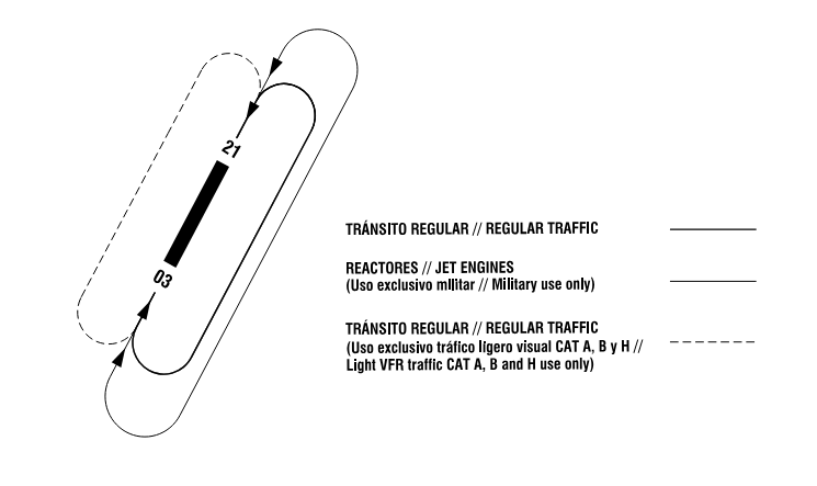](https://biblioteca.vatsimspain.es/uploads/images/gallery/2024-05/2v3image.png) #### **SALIDAS Y LLEGADAS**Las aeronaves VFR establecerán contacto con TWR antes de alcanzar **N** (Tinajo).
Las aeronaves VFR establecerán contacto con TWR antes de alcanzar los puntos **E** y **S (Punta Gorda).**
[](https://biblioteca.vatsimspain.es/uploads/images/gallery/2024-05/a7Vimage.png) --- #### **INFORMACIÓN ADICIONAL**Si has encontrado información errónea en esta página o hay algo que crees que podrías mejorar, comunicalo por [email a operaciones](https://vatsimspain.es/staff).
# GCTS | Tenerife Sur [TWR,GND,DEL] ## **Posiciones**| **LOGIN** | **DISTINTIVO DE LLAMADA** | **FRECUENCIA** |
| **GCTS\_ATIS** | **Tenerife Sur Atis** | **118.675** |
| **GCTS\_DEL** | **Tenerife Sur Delivery** | **121.750** |
| **GCTS\_GND** | **Tenerife Sur Ground** | **121.900** |
| **GCTS\_TWR** | **Tenerife Sur Tower** | **119.000** |
**Para estas posiciones recomendamos utilizar GCTS\_GND\_GR.asr.**
[](https://biblioteca.vatsimspain.es/uploads/images/gallery/2023-11/wNdimage.png) ##### **GCTS\_TWR****Para esta posición recomendamos utilizar GCTS\_GND\_GR.asr junto a GCCC.asr y alternar mediante "F7".**
**Con el GCCC.asr seleccionado, debes dirigirte al display Settings dialog y seleccionar el TAG de SACTA TWR en el desplegable.**
[](https://biblioteca.vatsimspain.es/uploads/images/gallery/2023-11/I2Fimage.png)**Para activar líneas de los estacionamientos y las de taxi en GCTS\_GND\_GR.asr , hay que seleccionarlas en FUNCTIONS -> MAPS-> GCCC.**
--- ## **Reglamentación Local****La pista preferente es la 07.**
**A los vuelos de escuela con alumno solo (letra S al final del indicativo) se le añadirá la palabra "solo" en la primera llamada.**
- **CNA16S**: Canavia uno seis solo (primera llamada). - **CNA16S:** Canavia uno seis sierra (resto de comunicaciones).**Los Helicópteros serán tratados como aeronaves de ala fija.**
Los puestos de estacionamientos habilitados para helicópetros son: E49, R19, J22, AG2 y AG5.**En los siguientes escenarios es recomendable (no obligatorio) el uso del idioma inglés cuando exista un piloto que no sea de habla castellana.**
- Autorizaciones de aterrizaje con tráfico en el punto de espera. - Autorizaciones de despegue con tráfico en final. - Autorizaciones para entrar y alinear desde puntos de espera congestionados.**Esto no aplica a los pilotos de habla castellana bajo reglas VFR.**
--- ### **Autorizaciones** Las aeronaves sin equipamiento RNAV1 serán autorizadas a la salida de contingencia **GCTS1W/1H** (seleccionable en el desplegable SID de la departure list). --- ### **Retrocesos****Los retrocesos desde los puestos frontales se autorizarán aproando a la cabecera en uso.**
Excepciones: - Que el controlador indique lo contrario por razones operativas o de seguridad. - En los puestos R19, G20, AG21 y J22 que serán aproando al este.**No se permiten retrocesos simultáneos en puestos adyacentes.**
**No se permite el retroceso desde un puesto con una aeronave entrando al puesto adyacente.**
Excepciones: - Ambas aeronaves estén informadas de la maniobra. - Que la aeronave más alejada de la cabecera en uso sea autorizada a un retroceso largo y una vez comience el retroceso, se le autorice a un retroceso corto a la otra aeronave. - Que una aeronave realice el retroceso aproando a la cabecera en uso y la otra lo realice aproando a la cabecera contraria, siempre y cuando exista una puerta de plataforma disponible entre ambas aeronaves.**Los retrocesos simultáneos desde G10 y H37 y desde G2 y J1 son incompatibles en todos los casos.**
En los aeropuertos Canarios es muy común que los ATR42/72 operados noramlmente por Binter o Canaryfly soliciten retroceso con motor (powerback). Este consiste en retroceder mediante el empuje del motor. Ejemplo de fraseología: - **IBB828:** Solicitamos puesta en marcha y retroceso con motor. - **ATC:** Puesta en marcha y retroceso con motor aprobado aproando al oeste, QNH 1023. - **IBB828:** Request startup and powerback. - **ATC:** Startup and poweback aproved facing west, QNH 1023. --- ### **Rodajes****No se permiten las entradas simultáneas en puestos adyacentes.**
**Las entradas simultáneas a G10 y H37 y a G2 y J1 son incompatibles.**
##### **Limitaciones** La puerta de plataforma **D1** está limitada a aeronaves de clave D o inferior salvo B767. La puerta de plataforma **D6** está limitada a aeronaves de clave D o inferior salvo B767-400 **para tráficos en salida hacia la pista 25.** **B1** está limitada a aeronaves de clave D o inferior. **B2** está limitada a aeronaves de clave D o inferior (máxima longitud de 50 m y máxima envergadura de 51 m) **para entrada en pista.** El giro hacia el este tras salida rápida por **B3** está limitada a aeronaves de clave D o inferior. **B5** no puede ser utilizada por A346 y B773. **B6** está limitada a aeronaves de clave D o inferior salvo B767 y para entrada en pista la longitud máxima es de 58 m. Las **calles de rodaje de aviación general** están limitadas a una envergadura máxima de 22 m. ##### **Aeronaves de clave F** ##### B748 y A124**Los puestos de estacionamiento son el S41 y R19.**
**Solo podrán utilizar las puertas de plataforma D2 y D6 y los puntos de espera B0 y B7.**
##### A388 y AN225**El puesto de estacionamiento es el S41.**
**Solo podrán utilizar la puerta de plataforma D2 y los puntos de espera B0 y B7.**
--- ## **Salidas****Se asumirá que el piloto está listo para salir cuando lleguen al punto de espera de la pista.**
**Se aplicará un mínimo de 2 minutos de separación entre salidas sucesivas.**
**Si la categoría de la primera aeronave es superior a la segunda se ha de aplicar 3 minutos.**
--- ### **Llegadas****En operación normal GCTS\_APP aplicará una mínima de separación horizontal de 8 NM.**
**Esta separación puede ser reducida a 5 NM previa coordinación con GCTS\_TWR en caso de no haber salidas.**
--- ### **VFR****Los circuitos de tránsito se realizarán al sur del campo.**
[](https://biblioteca.vatsimspain.es/uploads/images/gallery/2023-11/TyFimage.png) ##### **Salidas** GCTS\_TWR pasará los tráficos a la siguiente dependencia superior o a UNICOM una vez la aeronave abandone el CTR. ##### **Llegadas** GCTS\_TWR será el encargado de autorizar a los tráficos a entrar al CTR, pudiendo autorizar a las aeronaves a efectuar órbitas sobre los puntos de notificación E, W o S antes de obtener la autorización de entrada al CTR. [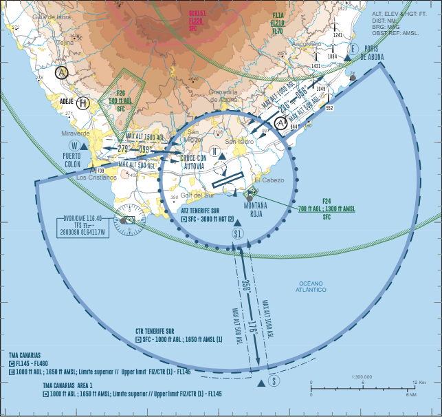](https://biblioteca.vatsimspain.es/uploads/images/gallery/2024-05/K2qimage.png) --- #### **INFORMACIÓN ADICIONAL**Si has encontrado información errónea en esta página o hay algo que crees que podrías mejorar, comunicalo por [email a operaciones](https://vatsimspain.es/staff).
# GCXO | Tenerife Norte [TWR,GND,DEL] ## **GCXO**Toda la información y cartas más detalladas disponible en: [**AIP Enaire - GCXO.**](https://aip.enaire.es/AIP/AIP-en.html#GCXO)
### **POSICIONES**| **LOGIN** | **DISTINTIVO DE LLAMADA** | **FRECUENCIA** |
| **GCXO\_ATIS** | **Tenerife Norte Atis** | **118.575** |
| **GCXO\_DEL** | **Tenerife Norte Delivery** | **121.850** |
| **GCXO\_GND** | **Tenerife Norte Ground** | **121.700** |
| **GCXO\_TWR** | **Tenerife Norte Tower** | **118.700** |
Más información sobre el espacio aéreo en: **[AIP - Datos de aerodromo GCXO.](https://aip.enaire.es/AIP/contenido_AIP/AD/AD2/GCXO/LE_AD_2_GCXO_en.pdf)**
--- ### **CONFIGURACIÓN EN EUROSCOPE** ##### **GCXO\_DEL y GCXO\_GND****Para estas posiciones recomendamos utilizar GCXO\_GND\_GR.asr**
[](https://biblioteca.vatsimspain.es/uploads/images/gallery/2024-05/t2ximage.png) ##### **GCXO\_TWR****Para esta posición recomendamos utilizar GCXO\_GND\_GR.asr junto a GCCC.asr y alternar mediante "F7".**
**Con el GCCC.asr seleccionado, debes dirigirte al display Settings dialog y seleccionar el TAG de SACTA TWR en el desplegable.**
[](https://biblioteca.vatsimspain.es/uploads/images/gallery/2024-05/screenshot-2024-05-25-131314.png)**Para activar líneas de los estacionamientos y las de taxi en GCXO\_GND\_GR.asr , hay que seleccionarlas en FUNCTIONS -> MAPS-> GCCC**
--- ### **REGLAMENTACIÓN LOCAL****La pista preferente para Tenerife Norte es pista 30.**
#### DESPEGUES INTERSECCIÓN: Los despegues desde intersección están disponibles desde: - Pista 12: int. E-2 - Pista 30: int E-4 [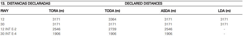](https://biblioteca.vatsimspain.es/uploads/images/gallery/2025-02/VNoimage.png) #### HELICÓPTEROS:Los helicópteros serán tratados cómo aeronaves de ala fija.
Acceso a plataforma para los helicópteros: - Plataforma Aviación General via **Y1** o **W1**. #### IDIOMAS:En los siguientes escenarios es recomendable (no obligatorio) el uso del idioma inglés cuando exista un piloto que no sea de habla castellana.
- Autorizaciones de aterrizaje con tráfico en el punto de espera. - Autorizaciones de despegue con tráfico en final. - Autorizaciones para entrar y mantener desde puntos de espera congestionados.Esto no aplica a los pilotos de habla castellana bajo reglas VFR.
Más información sobre la reglamentación en: **[AIP - Datos de aerodromo GCXO.](https://aip.enaire.es/AIP/contenido_AIP/AD/AD2/GCXO/LE_AD_2_GCXO_en.pdf)**
--- ### **AUTORIZACIONES****La altitud de transición es 6000ft.**
- El ascenso inicial es **FL070** para todas las salidas; si QNH < 1014 el ascenso inicial será a **altitud 6000 pies.** #### **SALIDAS DE CONTINGENCIA**| **Pista** | **12** | **30** |
| **Procedimiento** | **Rumbo pista y ascenso a FL070 (6000 ft. si QNH < 1014) posterior instrucciones ATC.** | **Rumbo 301 grados y ascenso a FL070 (6000 ft si QNH < 1014), posterior instrucciones ATC.** |
**GXCO dispone de DCL.**
**Más información sobre las salidas en el AIP: [AIP - Cartas GCXO SID 12](https://aip.enaire.es/AIP/contenido_AIP/AD/AD2/GCXO/LE_AD_2_GCXO_SID_1_en.pdf) [AIP - Cartas GCXO SID 30](https://aip.enaire.es/AIP/contenido_AIP/AD/AD2/GCXO/LE_AD_2_GCXO_SID_2_en.pdf)** #### **RETROCESOS**| **Pista** | **12** | **30** |
| **Dirección** | **Aprobando oeste** | **Aprobando este** |
**No se permiten retrocesos simultáneos en puestos adyacentes.**
**No se permite el retroceso desde un puesto con una aeronave entrando al puesto adyacente.**
Más información sobre las parkings y retrocesos: **[AIP - Cartas PDC GCXO.](https://aip.enaire.es/AIP/contenido_AIP/AD/AD2/GCXO/LE_AD_2_GCXO_PDC_1_en.pdf)**
--- ### **RODADURA** #### **PISTA 12** [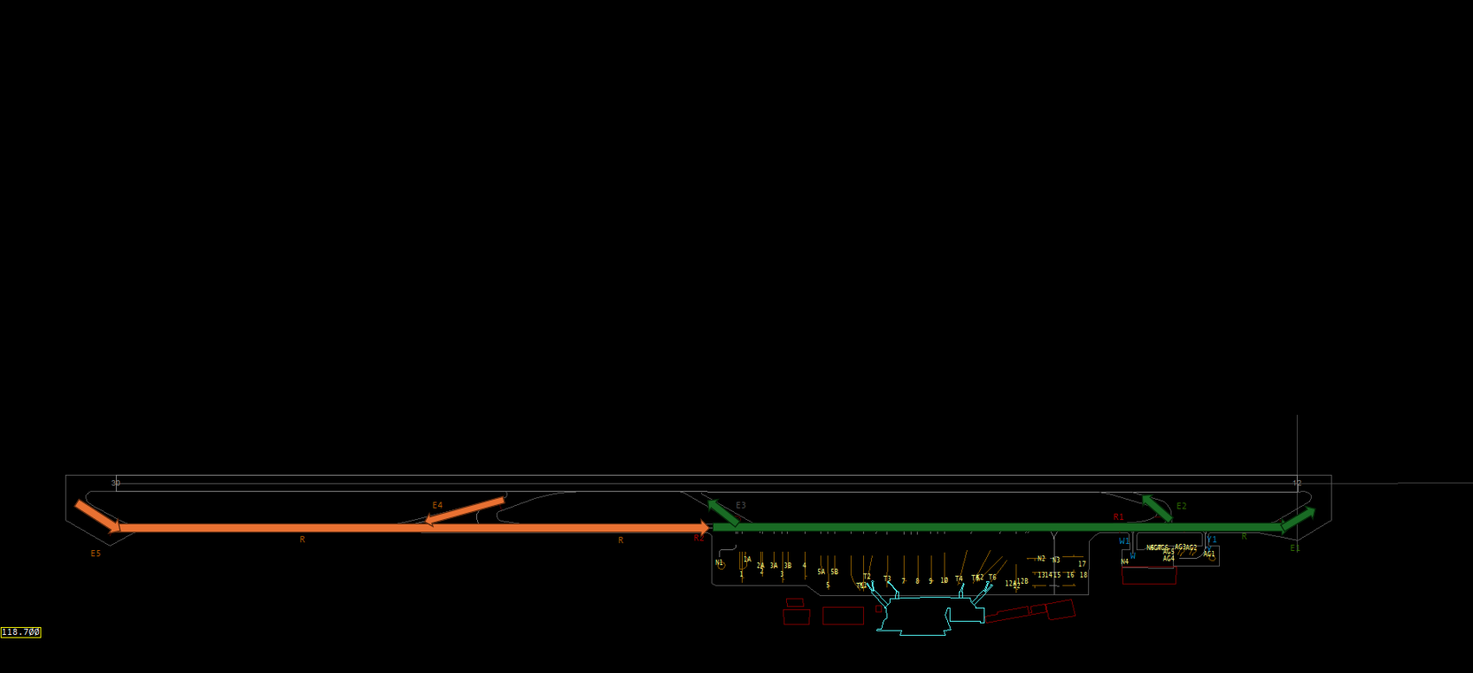](https://biblioteca.vatsimspain.es/uploads/images/gallery/2025-06/EW1image.png) #### **PISTA 30** [](https://biblioteca.vatsimspain.es/uploads/images/gallery/2025-06/image.png) **Limitaciones envergadura:** - Intersección E-3: **30m** \- TWY Y-1: **26m** \- TWY W-1: **26m** #### **Helicópteros** Helicópteros serán tratados cómo aeronaves de ala fija.Más información sobre la reglamentación local y rodadura en: **[AIP - Datos de aerodromo GCXO](https://aip.enaire.es/AIP/contenido_AIP/AD/AD2/GCXO/LE_AD_2_GCXO_en.pdf ""Datos de aerodromo GCLP"") y [AIP - Cartas GMC GCXO.](https://aip.enaire.es/AIP/contenido_AIP/AD/AD2/GCXO/LE_AD_2_GCXO_GMC_en.pdf)**
--- ### **TORRE** #### **Salidas**Se asumirá que el piloto está listo para salir cuando lleguen al punto de espera de la pista.
| **Pista** | **12** | **30** |
| **Separación con misma salida** | **6 NM o 3 minutos** | **6 NM o 3 minutos** |
| **Separación con distintas salidas** | **5 NM o 2,5 minutos** | **5 NM o 2,5 minutos** |
Misma SID son las que el viraje inicial va al norte o al sur, respectivamente. Es decir, todas las que viran inicialmente al norte son misma SID, por un lado, y todas las que viran al sur inicialmente, por otro lado.
Esto es aplicable si la performance es igual entre ambas aeronaves en despegue. Si la performance de la primera es inferior a la segunda, entonces la segunda queda SUJETA y hace falta SUELTA por parte de APP/CTR.
#### **Llegadas**| **Pista** | **12** | **30** |
| **Separación** | **8 NM** | **8 NM** |
| **Con coordinación con torre** | **6 NM** | **6 NM** |
Los **circuitos de tránsito** se pueden realizar por el **ambos** lados del campo.
[](https://biblioteca.vatsimspain.es/uploads/images/gallery/2024-05/iOtimage.png) #### **SALIDAS Y LLEGADAS**Las aeronaves VFR establecerán contacto con APP antes de alcanzar los puntos **N, E, S y W.**
[](https://biblioteca.vatsimspain.es/uploads/images/gallery/2024-05/TP2image.png) --- #### **INFORMACIÓN ADICIONAL**Si has encontrado información errónea en esta página o hay algo que crees que podrías mejorar, comunicalo por [email a operaciones](https://vatsimspain.es/staff).
# GCHI | El Hierro [TWR, AFIS]Existe un suplemento activo que afecta a GCHI. **Hasta el 16 de abril de 2027** estimado**, el DVOR/DME LPC estará fuera de servicio** por sustitución del sistema. **Procedimientos afectados::** SID RWY 16: **Salida LPC2X: salida no disponible. Ref: [ENAIRE SUP 56/26](https://aip.enaire.es/aip/contenido_SUP/LE_SUP_A_2026_056_es.html)**
### **POSICIONES**| **LOGIN** | **INDICATIVO DE LLAMADA** | **FRECUENCIA** |
| **GCHI\_TWR** | **El Hierro Tower/Information\*** | **118.075** |
**Para esta posición recomendamos utilizar GCHI\_GND\_GR.asr junto a GCCC.asr y alternar mediante 'F7'.**
[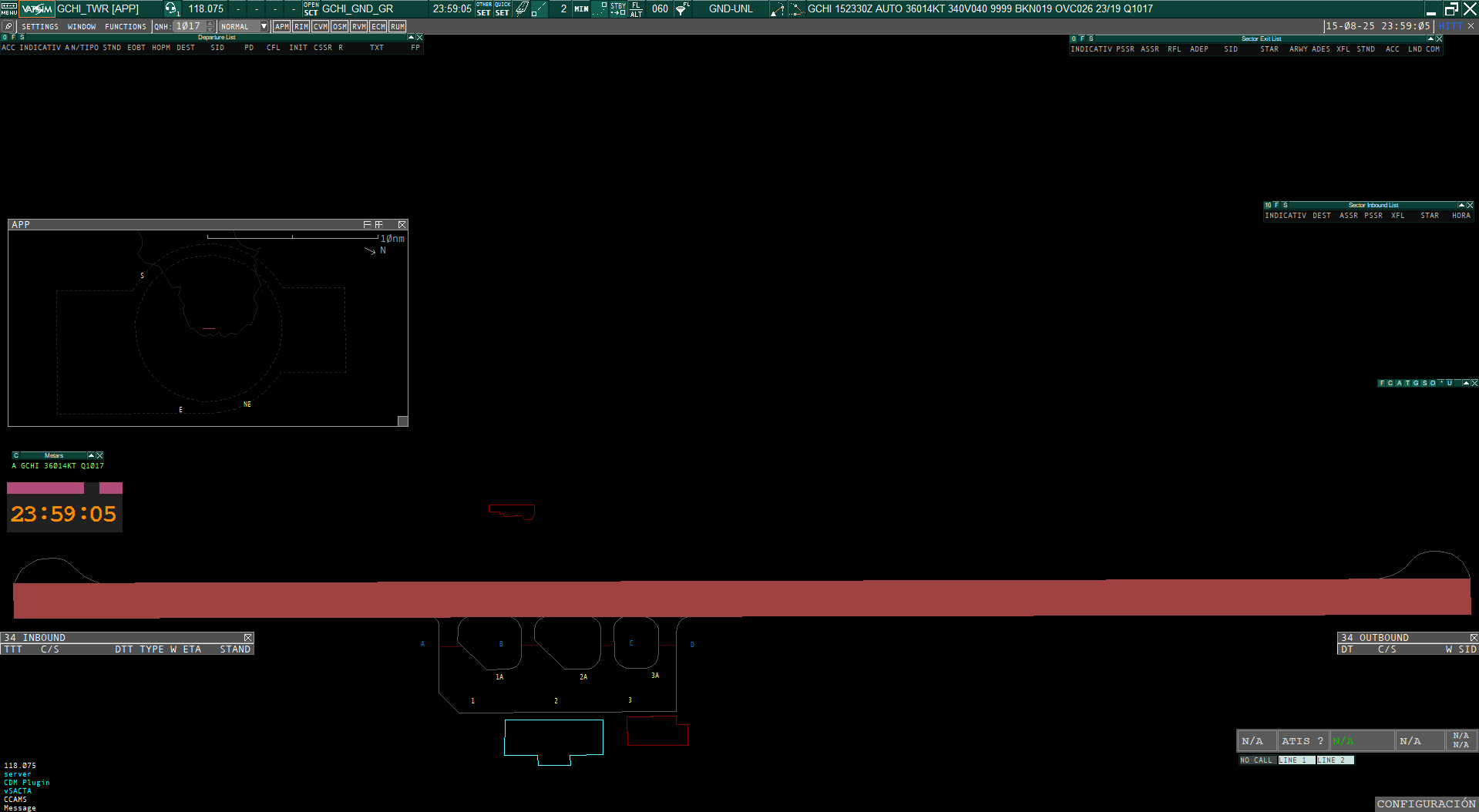](https://biblioteca.vatsimspain.es/uploads/images/gallery/2025-08/captura-de-pantalla-2025-08-16-015911.png)**Con el GCCC.asr seleccionado, debes dirigirte al *display settings dialog* y seleccionar el TAG de SACTA TWR en el desplegable.**
[](https://biblioteca.vatsimspain.es/uploads/images/gallery/2025-08/vTWimage.png) ### **SERVICIO ATIS****El Hierro no ofrece servicio ATIS**. Por lo tanto según [RCA 4.5.5.2.1.](https://www.transportes.gob.es/recursos_mfom/comodin/recursos/libro_completo_feb2019_v1_-_web.pdf) deberemos ofrecer la siguiente información meteorológica y/o de AD.
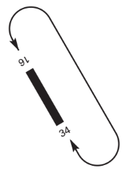
**a) la pista que ha de utilizarse;** **b) la dirección y velocidad del viento en la superficie, incluyendo variaciones importantes de la mismas:** **c) el reglaje QNH de altímetro, y, bien sea regularmente de conformidad con acuerdos locales o si la aeronave lo solicita, el reglaje QFE del altímetro;** **d) la temperatura del aire ambiente en la pista que ha de utilizarse, en el caso de aeronaves con motor de turbinas.** **e) la visibilidad representativa del sentido de despegue y ascenso inicial, si es inferior a 10 km, o de ser aplicable el valor del RVR correspondiente a la pista que ha de utilizarse.** **f) la hora exacta.** #### NOTIFICACIÓN DE CIZALLADURA EN APROXIMACIÓN O DESPEGUE En el caso de que los tránsitos reporten cizalladura de viento en la aproximación o despegue, se les solicitará a los pilotos la siguiente información: - Fase del vuelo en la que ha tenido lugar. - Intensidad: débil, moderada, fuerte, muy fuerte o sin calificar. - Sentido del fenómeno: positivo o negativo. - Si ha sido detectada por el sistema de la aeronave o percibida por el piloto. - Cualquier otra información complementaria disponible. Una vez informado del fenómeno de cizalladura, el ATCO o AFISO lo comunicará a las aeronaves siguientes que pudieran estar afectas. Asimismo, el ATCO o AFISO confirmará con estas aeronaves si la han experimentado o no. Deberemos notificar a la dependencia superior, si la hubiera, de esta fenomenología hasta que estas condiciones meteorológicas particulares dejen de representar significancia para los tránsitos. ### **PROCEDIMIENTOS LOCALES DE LA DEPENDENCIA** #### REGLAMENTACIÓN LOCAL - No estás permitidas las operaciones de ultraligeros. - Para operar con servicio AFIS dentro de la FIZ es obligatorio que las aeronaves presenten plan de vuelo y que estén equipadas con radiocomunicación en ambos sentidos. - Solo se permitirá, dentro de la FIZ, una única operación IFR simultánea. Los procedimientos al respecto se desarrollarán posteriormente en este documento. - Las aproximaciones instrumentales son utilizables únicamente si se dan condiciones VMC en el entorno del aeródromo, al estar certificado con pista de vuelo visual. Teniendo en cuenta que no podemos limitar a los pilotos a aterrizar en el aeropuerto, se le informará al piloto de las condiciones meteorológicas que le sean relevantes. #### PISTA PREFERENTE**La pista preferente de El Hierro es la pista 16**. Sin embargo, la **pista 34** suele ser la de uso más común, debido al alisio del noreste, que es el viento predominante.
#### DESPEGUE DESDE INTERSECCIÓN Los pilotos que lo soliciten, podrán despegar desde cualquiera de las intersecciones disponibles. En la autorización de despegue aplicaremos la siguiente fórmula:*XXXXX, viento X grados, X nudos, pista X, **intersección X**, autorizado a despegar.*
#### PROCEDIMIENTOS EN CONDICIONES DE BAJA VISIBILIDAD El aeropuerto de El Hierro **no dispone de Procedimientos de Visibilidad Reducida (LVP)**. #### PROCEDIMIENTOS DE SALIDA**La altitud inicial para todos las salidas es de 5000 pies.**
Se recuerda que **cuando operemos GCHI** **como AFIS** no se autorizará (p. ej. autorizaciones para aterrizar o despegar) ni se instruirá (p. ej. entrar en viento en cola, proceder a X punto) sino que daremos direccionamiento a las aeronaves a fuera y a dentro de la plataforma. **Solo proveeremos información de vuelo y Servicio de Dirección de Plataforma (SDP).** En este caso, la autorización IFR deberá tener la autorización de una dependencia superior que ofrezca servicio de control. Por ejemplo: ***Canarias Control les autoriza a..., etc.***
Como comentábamos anteriormente, **solo se permite una operación IFR simultánea en el FIZ**. Para dar cumplimiento de estos requisitos, la autorización ATC para tránsitos en salida debe contener la siguiente información: - (Indicativo de la aeronave) autorizado a XXXX - Salida, ya sea publica para la pista 16 o por la 34 en condiciones VMC para incorporarse a una SID publicada. - Código SSR. - Frecuencia de transferencia en salida. - Y toda la información meteorológica requerida como especificado anteriormente.| **AD** | **TIPO** | **PROCEDIMIENTO** | **PUNTOS** | **PROCEDIMIENTO** **OPERATIVO** | **DEPENDENCIA** |
| **GCHI** | **DEP 16** | **ARACO1X** | **ARACO** | **SEGÚN PUBLICADO** | **GCCC** |
| **LPC2X** | **TOMOS** | ||||
| **TFN2X** | **MOROD TESEL TFN** | ||||
| **YELBE1X** | **YELBE** | ||||
| **DEP 34\*** | **FD34ARACO** | **ARACO** | **RWY 34 VMC PARA INCORPORARSE A SID ARACO1X** | ||
| **FD34LPC** | **TOMOS LPC** | **RWY 34 VMC PARA INCORPORARSE A SID LPC2X** | |||
| **FD34TFN** | **MOROD TESEL TFN** | **RWY 34 VMC** **PARA INCORPORARSE A TFN2X** | |||
| **FD34YELBE** | **YELBE** | **RWY 34 VMC** **PARA INCORPORARSE A YELBE1X** |
Cuando el piloto al mando de una aeronave IFR notifique sus intenciones de cancelar plan de vuelo IFR, el ATC se limitará a acusar recibo con la siguiente fraseología: **"Plan de vuelo IFR cancelado a las ..."**
Y se le instruirá para que proceda a los puntos de notificación visuales "E" y "NE" a 1000 pies o inferior o bien, 500 pies inferior siempre que exista notificación de tránsitos IFR dentro de la FIZ o con entrada prevista en la misma, indicándole la finalización del servicio de control.No debe sugerirse el cambio de vuelo IFR a VFR ni directa ni implícitamente. ([RCA 4.2.9.1](https://www.transportes.gob.es/recursos_mfom/comodin/recursos/libro_completo_feb2019_v1_-_web.pdf)).
- Ante la certificación de GCHI como "pista visual", se especifica la actuación del CTA: - **Cuando GCHI opere como aeródromo controlado:** El CTA del ACC de Canarias solo podrá autorizar y aproximación instrumental si el campo se encuentra en condiciones VMC ([SERA 5001](https://www.easa.europa.eu/en/document-library/easy-access-rules/online-publications/easy-access-rules-standardised-european?page=6#_Toc256000054): visibilidad 5 km y distancia a nubes 1.500 mts. horizontalmente y 1.000 ft verticalmente)| **Pista** | **16** | **34** |
| **Separación** | **15 NM** | **15 Nm** |
Se recuerda nuevamente que no podremos prohibir a los pilotos realizar la aproximación, y que deberemos informar al piloto de las condiciones meteorológicas para que este proceda a su discreción.
El aeropuerto queda restringido a aeronaves de categoría superior a A y B.
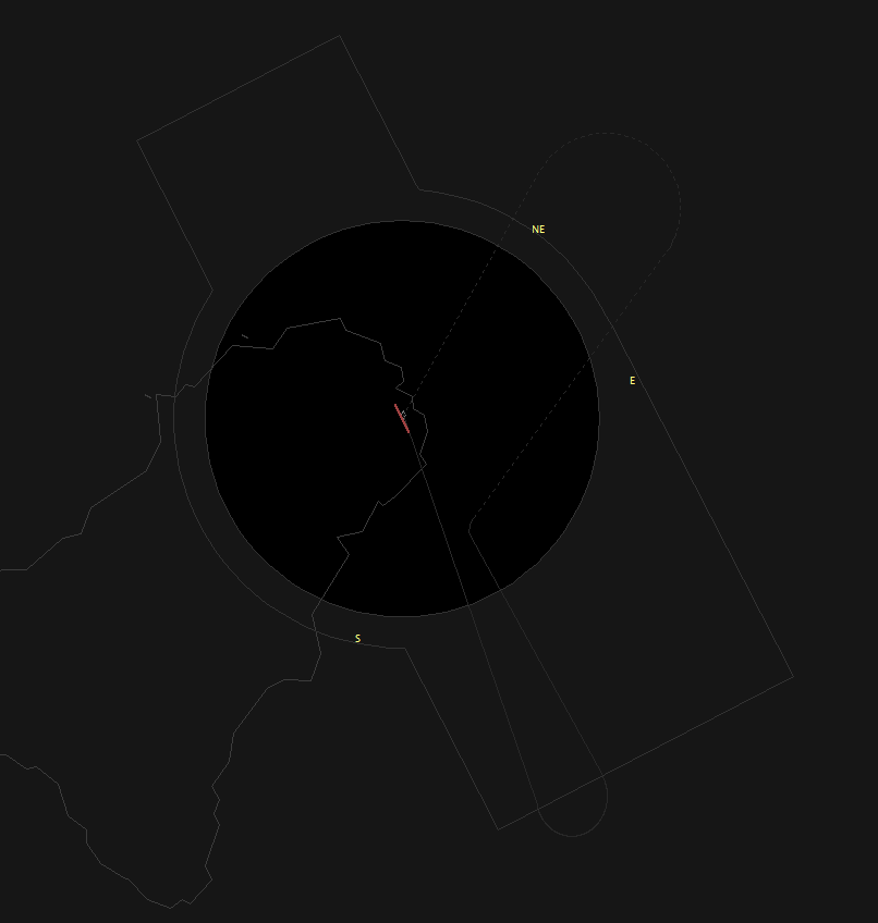
#### PROCEDIMIENTOS VISUALES - **AFIS:** - ***Llegadas:*** tránsito VFR con destino El Hierro AD notificarán sus intenciones a la Dependencia AFIS ante de alcanzar los puntos de notificación y entrarán en la FIZ siguiendo las rutas y altitudes establecidas. - ***Salidas:*** tránsito VFR que deseen abandonar la FIZ, notificarán sus intenciones a la Dependencia AFIS, informando de la ruta de salida y el punto de referencia a utilizar, manteniendo las altitudes publicadas. - **TWR:** - ***Llegadas:*** tránsito VFR con destino El Hierro AD establecerán contacto radio con Hierro TWR antes de alcanzar los puntos de notificación: NE, E, o S y solicitarán autorización para entrar en la CTR siguiendo las rutas establecidas y altitudes publicadas. - ***Salidas:*** tránsito VFR que desee abandonar la CTR recibirá instrucciones de TWR, antes del despegue del punto de salida a utilizar. Las aeronaves notificarán a TWR en el momento en que se abandone el límite de la CTR manteniendo las altitudes publicadas. - **Circuitos de tránsito de AD:**Los circuitos de tránsito solo están disponible **al este del campo.**
[](https://biblioteca.vatsimspain.es/uploads/images/gallery/2025-08/UtWimage.png) #### RODADURA Y ENVERGADURA MÁXIMA [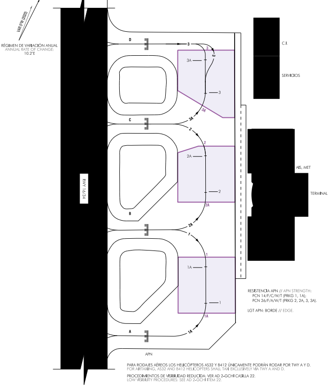](https://biblioteca.vatsimspain.es/uploads/images/gallery/2025-08/qAjimage.png) La rodadura de El Hierro, como podemos ver, no reviste mayor dificultad que las específicas en todo aeródromo que quiere de regreso por una pista y las particularidades intrínsecas a El Hierro, donde las incompatibilidades reportadas, como puede resultar lógico, son en los puestos aledaños al puesto de estacionamiento con el mismo número, es decir, el puesto de estacionamiento 1 es incompatible con el 1A, el 2 con el 2A y el 3 con el 3A, y viceversa.| **PUESTO DE ESTACIONAMIENTO** | **MAX** **SPAN** | **INCOMPATIBLE CON** |
| 1 | AT72 | 1A |
| 2 | AT72 | 2A |
| 3 | AT72 | 3A |
Si has encontrado información errónea en esta página o hay algo que crees que podrías mejorar, comunícalo por [email a operaciones.](https://vatsimspain.es/vacc/staff/)
# GCGM | La Gomera [AFIS] ### **POSICIONES**| **LOGIN** | **INDICATIVO DE LLAMADA** | **FRECUENCIA** |
| **GCGM\_I\_TWR** | **La Gomera Information** | **118.375** |
Se recuerda que **La Gomera opera como un AFIS y no ofrece servicio de control, sino de información de vuelo y Servicio de Dirección de Plataforma (SDP)**, lo que implica que no daremos autorizaciones ni instrucciones fuera de la plataforma, donde podremos instruir a los tránsitos a rodar a una intersección en salida o a un puesto de estacionamiento en llegada. [ **Se recomiendo la lectura del documento ENR 1.5 - 4.2. PROCEDIMIENTO EN AERÓDROMOS** ](https://aip.enaire.es/aip/contenido_AIP/ENR/LE_ENR_1_5_en.pdf)**[AFIS](https://aip.enaire.es/aip/contenido_AIP/ENR/LE_ENR_1_5_en.pdf).**
### **ESPACIO AÉREO** [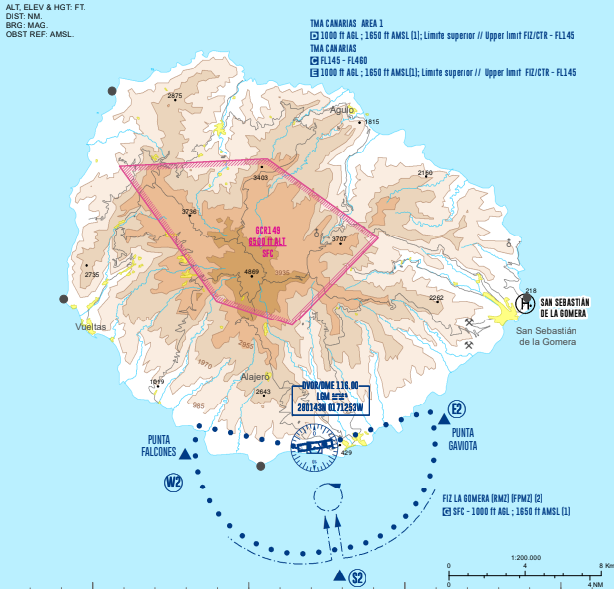](https://biblioteca.vatsimspain.es/uploads/images/gallery/2025-08/Mbfimage.png) #### ÁREA DE RESPONSABILIDAD| **ÁREA** | **LÍMITES VERTICALES** | **ESPACIO AÉREO** |
| **GCGM FIZ** | **SFC a 1000 ft AGL-1650 ft AMSL (lo que resulte mayor)** | **G** |
**Para esta posición recomendamos utilizar GCHI\_GND\_GR.asr junto a GCCC.asr y alternar mediante 'F7'.**
[](https://biblioteca.vatsimspain.es/uploads/images/gallery/2025-08/lOqimage.png)**Con el GCCC.asr seleccionado, debes dirigirte al *display settings dialog* y seleccionar el TAG de SACTA TWR en el desplegable.** Esto solo es de apoyo, ya que La Gomera AFIS no cuenta con sistema de presentación radar.
[](https://biblioteca.vatsimspain.es/uploads/images/gallery/2025-08/oHzimage.png) ### **SERVICIO ATIS****La Gomera no ofrece servicio ATIS.** Por lo tanto según [RCA 4.5.5.2.1.](https://www.transportes.gob.es/recursos_mfom/comodin/recursos/libro_completo_feb2019_v1_-_web.pdf) deberemos ofrecer la siguiente información meteorológica y/o de AD.
**a) la pista preferente;** **b) la dirección y velocidad del viento en la superficie, incluyendo variaciones importantes de la mismas:** **c) el reglaje QNH de altímetro, y, bien sea regularmente de conformidad con acuerdos locales o si la aeronave lo solicita, el reglaje QFE del altímetro;** **d) la temperatura del aire ambiente en la pista que ha de utilizarse, en el caso de aeronaves con motor de turbinas.** **e) la visibilidad representativa del sentido de despegue y ascenso inicial, si es inferior a 10 km, o de ser aplicable el valor del RVR correspondiente a la pista que ha de utilizarse.** **f) la hora exacta.** #### NOTIFICACIÓN DE CIZALLADURA EN APROXIMACIÓN O DESPEGUELas condiciones orográficas de la Isla de La Gomera y la situación del aeropuerto favorecen que, en determinadas circunstancias, aparezcan fenómenos que en determinadas circunstancias, aparezcan fenómenos de cizalladura y turbulencia.
En el caso de que los tránsitos reporten cizalladura de viento en la aproximación o despegue, se les solicitará a los pilotos la siguiente información: - Fase del vuelo en la que ha tenido lugar. - Intensidad: débil, moderada, fuerte, muy fuerte o sin calificar. - Sentido del fenómeno: positivo o negativo. - Si ha sido detectada por el sistema de la aeronave o percibida por el piloto. - Cualquier otra información complementaria disponible. Una vez informado del fenómeno de cizalladura, el AFISO lo comunicará a las aeronaves siguientes que pudieran estar afectas. Asimismo, el AFISO confirmará con estas aeronaves si la han experimentado o no. Deberemos notificar a la dependencia superior, si la hubiera, de esta fenomenología hasta que estas condiciones meteorológicas particulares dejen de representar significancia para los tránsitos. ### **PROCEDIMIENTOS LOCALES DE LA DEPENDENCIA** #### REGLAMENTACIÓN LOCAL - Solo se permiten tránsitos VFR o en su defecto planes de vuelo Y, en llegada o Z, en salida. - Aeródromo cerrado a aeronave sin radiocomunicaciones. - No se presta servicio de control en el aeropuerto de La Gomera. - Las aeronaves operarán con plan de vuelo y estarán equipadas con radiocomunicación en ambos sentidos. #### PISTA PREFERENTE**La pista preferente es la pista 27.**
#### TIEMPO MÍNIMO DE OCUPACIÓN DE PISTA (MROT) Para minimizar el tiempo de ocupación de pista y la posibilidad de "motor y al aire" se recuerda a los pilotos: - **Llegadas:** - Abandonar la pista con celeridad y a la mayor velocidad posible sin perjuicio de la seguridad. - Abandonar completamente la pista antes de detenerse. - **Salidas:** - Los pilotos estarán preparados para salir cuando lleguen al punto de espera de la pista. #### DESPEGUE DESDE INTERSECCIÓNLas aeronaves que deseen despegar desde intersección, deberán solicitarlo, preferentemente, al mismo tiempo que la puesta en marcha.
**Los pilotos que lo soliciten, podrán despegar desde la intersección A**. En la información de despegue aplicaremos la siguiente fórmula:*XXXXX, viento X grados, X nudos, **intersección X.*** Pista X libre, sin tránsitos notificados.
#### PROCEDIMIENTOS EN CONDICIONES DE BAJA VISIBILIDAD El aeropuerto de La Gomera **no dispone de Procedimientos de Visibilidad Reducida (LVP)**. #### PROCEDIMIENTOS DE SALIDA**La Gomera no posee altitud inicial para sus salidas publicadas. La ruta W2-BOXCO tiene una restricción de nivel a FL070.** Se deberá coordinar con la dependencia superior la altitud o nivel de vuelo a la que el tránsito en salido deberá subir.
- Para el tránsito con plan de vuelo Z saliendo del aeropuerto, las coordinaciones serán: - La Gomera AFIS informará a Tenerife Sur Aproximación o dependencia superior la pista requerida por el piloto y solicitará autorización ATC. - Tenerife Sur Aproximación comunicará a La Gomera AFIS la autorización ATC. - La Gomera AFIS transmitirá la autorización al piloto y vigilará el cumplimiento de la misma a Tenerife Sur Aproximación cuando se produzcan desviaciones. - Así mismo, La Gomera AFIS informará cundo se inicie el rodaje para el despegue de la aeronave. - La autorización ATC debe contener la siguiente información: - Límite de autorización, ya sea un punto de la llegada o una ayuda primaria del aeropuerto de destino (IAF). - Punto de entrada y ruta autorizada. - Código SSR - Dependencia ATC y frecuencia con la que debe contactar después de la salida. - Altitud o nivel de vuelo autorizado. - Otras instrucciones de salida, si fueran necesarias. Para ilustrar esto, pondremos un ejemplo:*RSC1LK, Tenerife Sur les autoriza a Gran Canaria vía ruta publicada S2-ESIQE. En instrumental transición ESIQE1C, suban a FL90, respondan 1357.*
| **AD** | **TIPO** | **PROCEDIMIENTO** | **PUNTOS** | **PROCEDIMIENTO** **OPERATIVO** | **DEPENDENCIA** |
| **GCGM** | **DEP\*** | **FDBOXCO** | **W2 GM921 GM922 BOXCO** | **SEGÚN PUBLICADO** | **GCCC** |
| **FDESIQE** | **S2 ESIQE** | **SEGÚN PUBLICADO** |
Cuando el piloto al mando de una aeronave IFR notifique sus intenciones de cancelar plan de vuelo IFR, el ATC se limitará a acusar recibo con la siguiente fraseología: **"Plan de vuelo IFR cancelado a las ..."**
Y se le instruirá para que proceda a los puntos de notificación visuales "E2" y "W2" a 1000 pies siempre que exista indicándole la finalización del servicio de control.| **AD** | **TIPO** | **PROCEDIMIENTO** | **PUNTOS** | **PROCEDIMIENTO** **OPERATIVO** | **DEPENDENCIA** |
| **GCGM** | **ARR** | **FAYEQAY** | **YEQAY** | **(1)** | **GCCC** |
| **FAMOVAS** | **MOVAS CULNE E2** | **(2)** | |||
| **FAFRUSTRADAE2** | **E2** | **(3)** |
**Se vigilarán especialmente las siguientes situaciones: a) Salida de La Gomera AFIS por la pista 09 coincidiendo con una entrada al FIZ POR E2.** **b) Salida de La Gomera AFIS por la pista 27 coincidiendo con una entrada al FIZ por W2.**
#### PROCEDIMIENTOS VISUALES - **Llegadas:** tránsito VFR con destino La Gomera AD comunicará con la dependencia AFIS y notificará sus intenciones antes de alcanzar los puntos de notificación E2 (Punta Gaviota), W2 (Punta de Falcones) y S2, a 1000 ft AGL o 1650 ft AMSL. - **Salidas**: tránsito VFR que desee abandonar la FIZ, notificará sus intenciones a la dependencia AFIS, informando del punto de notificación a utilizar. - **Circuitos de tránsito de AD:**Los circuitos de tránsito solo están disponible **al sur del campo.**
[](https://biblioteca.vatsimspain.es/uploads/images/gallery/2025-08/qyUimage.png) #### RODADURA Y ENVERGADURA MÁXIMA [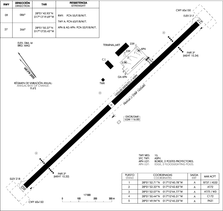](https://biblioteca.vatsimspain.es/uploads/images/gallery/2025-08/Bbsimage.png) [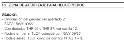](https://biblioteca.vatsimspain.es/uploads/images/gallery/2025-08/yzqimage.png)Si has encontrado información errónea en esta página o hay algo que crees que podrías mejorar, comunícalo por [email a operaciones.](https://vatsimspain.es/vacc/staff/)
# Oceánico Documentación sobre la posición de Canarias Radio. # Canarias Radio | Sector Oceánico #### **1. SERVICIOS PRESTADOS EN LA DEPENDENCIA** En la dependencia GCCO, se prestan los siguientes servicios: - Servicio de control de tránsito aéreo. - Servicios de asesoramiento. - Servicio de información de vuelo.| **\[UIR\] ESPACIO AÉREO GCCO** | ||
| **ÁREA** | **NIVEL** | **CLASE** |
| **PARTE 1** | **FL660** **╾╾╾╾╾╾╾╾╾╾╾╾** **FL245** **FL660** **╾╾╾╾╾╾╾╾╾╾╾╾** **UNL** | **C** **G** |
| **PARTE 2** | **FL245** **╾╾╾╾╾╾╾╾╾╾╾╾** **FL195** | **C** |
| **\[FIR\] ESPACIO AÉREO GCCO** | ||
| **ÁREA** | **NIVEL** | **CLASE** |
| **FIR CANARIAS** | **FL195** **╾╾╾╾╾╾╾╾╾╾╾╾** **FL145** **FL145** **╾╾╾╾╾╾╾╾╾╾╾╾** **SFC** | **C** **G** |
| **ÁREA SÁHARA** | **FL195** **╾╾╾╾╾╾╾╾╾╾╾╾** **SFC** **FL145** **╾╾╾╾╾╾╾╾╾╾╾╾** **SFC** | **G** **G** **(SALVO TMA LAAYOUNE, TMA DAKHLA Y AEROVÍAS)** |
| **AEROVÍA** | **NIVEL** | **CLASE** |
| **EURSAM** | **FL660** **╾╾╾╾╾╾╾╾╾╾╾╾** **FL195** | **C** |
| **N728** | **FL460** **╾╾╾╾╾╾╾╾╾╾╾╾** **FL195** **FL195** **╾╾╾╾╾╾╾╾╾╾╾╾** **FL095** | **C** **F** |
| **N729** | **FL660** **╾╾╾╾╾╾╾╾╾╾╾╾** **FL145** | **C** |
| **M660** | **FL660** **╾╾╾╾╾╾╾╾╾╾╾╾** **FL195** **FL195** **╾╾╾╾╾╾╾╾╾╾╾╾** **FL095** | **C** **F** |
| **L660** | **FL660** **╾╾╾╾╾╾╾╾╾╾╾╾** **FL195** **FL195** **╾╾╾╾╾╾╾╾╾╾╾╾** **FL095** | **C** **F** |
| **Y601** | **FL660** **╾╾╾╾╾╾╾╾╾╾╾╾** **FL195** | **C** |
| **T975** | **FL245** **╾╾╾╾╾╾╾╾╾╾╾╾** **FL195** **FL195** **╾╾╾╾╾╾╾╾╾╾╾╾** **FL145** | **C** **D** |
**GCCO\_FSS** no dará servicio a los TMA/CTA que recaen bajo su espacio aéreo. En concreto, **no asumirá** bajo ningún concepto **DAKHLA APP/TWR ni LAAYOUNE APP/TWR.** Estas son responsabilidad de Maghreb vACC.
La clasificación del espacio aéreo está recogida en el [AIP-España ENR 1.4](https://aip.enaire.es/AIP/contenido_AIP/ENR/LE_ENR_1_4_en.pdf). Los TMA bajo su jurisdicción se encuentran en el [AIP-España ENR 2.1](https://aip.enaire.es/AIP/contenido_AIP/ENR/LE_ENR_2_1_en.html). Los CTR y ATZ de aeródromos bajo la jurisdicción de la dependencia o a los que presta servicio se encuentran dentro del AD-2 (GCFV, GCGM, GCHI, GCLA, GCLP, GCRR, GCTS, GCXO, GSAI, EL AAIUN, GSVO VILLACISNEROS- La información de estos dos campos del Sahara no está actualizada en el AIP). ##### 2. 4. Delegaciones de espacio aéreo Las delegaciones de espacio aéreo que afectan a la dependencia se encuentran en el [AIP-España ENR 2.2.](https://aip.enaire.es/AIP/contenido_AIP/ENR/LE_ENR_2_2_en.pdf) ##### 2. 4. 1. Delegación ATS de Canarias ACC a Nouadhibou APP/TWR La provisión del servicio de tránsito aéreo está delegada a Nouadhibou APP dentro del espacio aéreo comprendido en: ##### 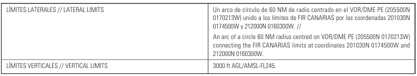 [](https://biblioteca.vatsimspain.es/uploads/images/gallery/2025-01/Z2Limage.png) --- - **Transferencia de comunicaciones:**| **RUTA ATS** | **Distintivo de llamada** | **Frecuencia primaria** |
| **L660** | **Canarias Control/Radio** | **133.000 MHz/8861 kHz** |
| **L660** | **Nouadhibou Approach** | **120.800 MHz** |
| **RUTA ATS** | **Punto de transferencia** |
| **L660** | **LOLOS 215100N 0164000W** **(60.0 DME/R-028 PE)** |
| **CORREDOR EUR/SAM** | |||
| **AEROVÍA** | **SENTIDO NORTE** | **SENTIDO SUR** | **FIJO DE INVERSIÓN** |
| **N741** | **N/A** | **PAR/IMPAR** | **N/A** |
| **N866** | **IMPAR** | **PAR** | **GOMER** |
| **N873** | **IMPAR** | **PAR** | **ODEGI** |
| **N857** | **IMPAR** | **PAR** | **DEREV** |
| **SÁHARA** | |||
| **AEROVÍA** | **SENTIDO NORTE** | **SENTIDO SUR** | **FIJO DE INVERSIÓN** |
| **N728** | **PAR** | **IMPAR** | **N/A** |
| **N729** | **IMPAR** | **PAR** | **DEREV** |
| **M660** | **IMPAR** | **PAR** | **N/A** |
| **L600** | **PAR** | **IMPAR** | **ARENA** |
| **Y601** | **PAR** | **IMPAR** | **KEMUL** |
| **T975** | **IMPAR** | **PAR** | **ECHED** |
| **Área** | **Límites verticales** | **Observaciones** |
| **GMR12** | **GND-500FT** | **Entrenamiento de aviones y helicópteros militares (se requiere autorización por parte de GMML TWR)** |
| **GMD23 - OULED EL KHAT** | **GND-FL250** | **Actividades aéreas militares activadas por NOTAM.** |
| **GMD24** | **FL150-FL460** | **Actividades aéreas militares activadas por NOTAM.** |
| **GMD38 - AMASSIN** | **GND-UNL** | **Entrenamiento militar aéreo** |
Las frecuencias de GMML y GMMH se encuentran contenidas en la LoA España-Maghreb.
Las frecuencias de los distintos espacios aéreos dentro de la jurisdicción de la dependencia se recogen en el [AIP-España ENR 2.1 ](https://aip.enaire.es/AIP/contenido_AIP/ENR/LE_ENR_2_1_en.html)y en las fichas de los aeródromos bajo jurisdicción de la dependencia dentro del [AD-2.2](https://aip.enaire.es/AIP/contenido_AIP/ENR/LE_ENR_2_2_en.pdf): GCFV, GCGM, GCHI, GCLA, GCLP, GCRR, GCTS, GCXO, GSAI EL AAIUN, GSVO VILLACISNEROS (La información de estos dos campos del Sahara no está actualizada en el AIP). #### CANARIAS RADIO (OCE)| **OCE** | |||
| **GCCO\_FSS** | Canarias Radio | 119.300 MHz / 133.000 MHz (HF)8861 kHz | Sector de control de ruta del ACC de Canarias cuyo jurisprudencia radica en las áreas definidas del Atlántica y el Sáhara en base a lo publicado en este manual y la LoA con Maghreb vACC. Es una Zona de Control Oceánica (OCA). |
Canarias Radio operará con las dos frecuencias 119.300 MHz y 133.000 MHz de acuerdo al área de control como se muestra en el esquemático del punto 2 *Espacio Aéreo*.
##### 3. 2. Uso de la información procedente de sistemas de vigilancia ATS.La cobertura radar en el sector Oceánico es reducida o inexistente en la mayoría de su volumen. Por lo tanto, el método de separación será convencional. **No se aplicará bajo ningún concepto separación entre pistas ADS.**
Los requisitos aplicables al control por procedimientos vienen regulados en: - [**Easy Access Rules (EAR) para ATM-ANS (Regulation (EU) 2017/373)**](https://www.easa.europa.eu/en/document-library/easy-access-rules/online-publications/easy-access-rules-atm-ans-regulation-eu?page=24&utm_source=chatgpt.com): en particular **ATS.TR.200** que define cuándo se presta el servicio de control de tránsito aéreo, incluyendo situaciones sin vigilancia ATS. - [**Easy Access Rules for Standardised European Rules of the Air (SERA; Regulation (EU) No 923/2012)**:](https://www.easa.europa.eu/en/document-library/easy-access-rules/online-publications/easy-access-rules-standardised-european?page=15#_DxCrossRefBm1523704451) SERA.7001 (“General — Objectives of the air traffic services”) entre otros artículos que describen los principios que deben cumplir los servicios ATS, incluidos los procedimientos sin vigilancia. - **[RCA, Libro IV](https://www.transportes.gob.es/recursos_mfom/comodin/recursos/libro_completo_feb2019_v1_-_web.pdf),** Capítulo correspondiente al Reglamento de Circulación Aérea en España, que incluye disposiciones para control por procedimientos La fraseología asociada a los servicios de control procedimental viene regulada en: - [Easy Access Rules (EAR) for Standardised European Rules of the Air (SERA): SERA.14001, Appendix 1, ](https://www.easa.europa.eu/en/document-library/easy-access-rules/online-publications/easy-access-rules-standardised-european?page=22#_DxCrossRefBm1523704572) - [Real Decreto 1180/2018, Anexo V: Fraseología, punto 1.2: Fraseología del Servicio de Control de Área.](https://www.boe.es/buscar/doc.php?id=BOE-A-2018-15406) ##### 3. 2. 1. Mínimas de separación horizontal y vertical Dentro el Sector Oceánico, serán de aplicación las siguientes mínimas de separación horizontal basados en el control convencional: - **Separación lateral**: 100 NM. Excepto: - Cuando las aeronaves transiten hacia un espacio aéreo con una mínima lateral mayor que la del espacio aéreo que abandonan, la separación lateral seguirá existiendo siempre que: - se aplique la mínima de separación más reducida. - las trayectorias de vuelo diverjan 15 grados o más que se establezca la mínima mayor; y - sea posible asegurar, por medios aprobados por la ATS competente, que las aeronaves disponen de la capacidad de navegación necesario para garantizar una guía precisa de la derrota. - Una separación mínima de 50NM entre aeronaves aprobadas para RNP 10 o mejor. - **Técnica del número Mach**: - El uso de la técnica del Número Mach permite la aplicación de mínimas reducidas de separación longitudinal. Las siguientes condiciones deben cumplirse cuando se aplica la Técnica del Número Mach: - Solo turborreactores. - Sobre las rutas: - Las aeronaves siguen la misma derrota o derrotas que divergen de forma continua, y - Las aeronaves involucradas han notificado sobre un punto común; o - Si las aeronaves no han notificado sobre un punto común, le intervalo de tiempo apropiado que se aplica entre aeronaves existe y se mantendrá en el punto común; o - Si no existe un punto común, el intervalo de tiempo apropiado que se aplica entre aeronaves existe y se mantendrá en los puntos significativos - Las aeronaves involucradas están niveladas, ascendiendo o descendiendo. - Un número Mach debe ser dado a cada aeronave.La aplicación de la técnica del Número Mach requiere que los pilotos **cumplan estrictamente con el último Número Mach asignado (o rango de Números Mach), incluso durante ascensos y descensos**, a menos que sea revisado por el control ATC. Las aeronaves a reacción (turborreactores) deben **solicitar aprobación al ATC antes de realizar cualquier cambio**. Si es necesario efectuar un cambio temporal inmediato en el Número Mach (por ejemplo, debido a turbulencia), se debe **notificar al ATC lo antes posible que se ha realizado dicho cambio**. Cuando sea necesario emitir **restricciones de cruce** para garantizar el intervalo de tiempo adecuado, **puede resultar imposible que una aeronave cumpla tanto con la autorización para cumplir las restricciones de cruce como con la autorización para mantener un único Número Mach específico**.([ICAO DOC 9426-AN/924, Part II, Section 2, Para 2.3.4, Para 2.4.7, and Para 2.5.3.](https://es.scribd.com/document/221957445/ICAO-Doc-9426))
***Ejemplos: - Maintain Mach point eight four or greater. - Maintain Mach point eight three or less. - Maintain Mach point eight two or greater; do not exceed Mach point eight four***
- - Mínima longitudinal: cuando la Técnica del Número Mach (TNM) se aplique, la separación mínima longitudinal debe ser de: - 10 minutos, teniendo en cuenta que: - La aeronave precedente mantenga un número Mach igual o mayor que la aeronave que sigue; o - Cuando la aeronave que sigue es más rápida que la precedente, al menos 10 minutos existen hasta que otra forma de separación se consiga; o - Entre 9 y 5 minutos inclusive, dado que la aeronave precedente mantenga un número Mach mayor que la aeronave que siga de acuerdo a lo siguiente: - 9 minutos: si la aeronave precedente es Mach 0.02 más rápida que la aeronave que sigue. - 8 minutos, si la aeronave precedente es Mach 0.03 más rápido que la aeronave que sigue. - 7 minutos, si la aeronave precedente es Mach 0.04 más rápida que la aeronave que sigue. - 6 minutos, si la aeronave precedente es Mach 0.05 más rápida que la aeronave que sigue. - 5 minutos, si la aeronave precedente es Mach 0.06 más rápida que la aeronave que sigue. [](https://biblioteca.vatsimspain.es/uploads/images/gallery/2025-09/6p1image.png) - **Separación longitudinal**: - La separación mínima longitudinal entre turborreactores debe ser de 20 MIN. - A o por encima de FL250, siempre que se aplique la Técnica del Número Mach (TNM) y, tanto en vuelo nivelado, como en ascenso o descenso, las aeronaves hayan notificado sobre el mismo punto de entrada a las rutas ATS o un punto común de entrada en el espacio aéreo controlado oceánico y sigan la misma derrota o derrotas que diverjan de forma continua: 15 MIN. - En rutas RNP 10 cuando se aplique la TNM: 10 MIN. - Separación basada en distancia longitudinal mínima de 50 NM entre aeronaves RNAV en el mismo curso en rutas RNP 10 no deben ser usadas. - **Separación vertical** - Se debe aplicar una separación mínima vertical de 1000 ft (300 m) entre aeronaves aprobadas RVSM entre FL290 y FL140 inclusive. - Aeronaves que no posean aprobación RVSM pueden ser autorizadas a operar en RVSM aplicándose una separación vertical de 2000 ft (600). ##### 3. 2. 2. Corredor EUR/SAM - **Área de aplicación** - El corredor EUR/SAM es el espacio aéreo sobre el área del Atlántico Sur que se encuentra dentro de las FIR de Atlántico, Canarias, Dakar Oceánico, Recife y Sal Oceánico. - RVSM y RNP 10 serán aplicables en ese volumen de espacio aéreo comprendido entre FL290 y FL410 en el siguiente espacio aéreo: - De 25º00’N/015º30’W; 17º20’N/020º00’W; 15º00’N/020º00’W; 12º58’N/021º22’W; 08º31’S/034º21W; 08º08.2’S/ 034º56’W (Recife VOR) luego seguir los límites continentales septentrionales de Brasil hasta el punto 01º21’S/043º08’W; 07º40N/035º00W; 13º30N/ 037º30’W; 17º00’N/037º30’W; 24º00’N/025º00’W; 30º00’N/025º00’W; 30º00’N/ 020º00’W; 31º39’N/017º25’W; desde este punto, siguiendo el límite Canarias/Lisboa hasta 31º30’14’’N/017º01’44’’W; 27º00’N/020º00’W; 25º00’N/020º00’W; 25º00’N/015º30’W [](https://biblioteca.vatsimspain.es/uploads/images/gallery/2025-09/uVQimage.png) *Imagen cortesía de [SATMASAT](https://satmasat.com/files/eur_sam/sat.pdf). La imagen se encuentra desactualizada, no tomar como referencia: solo sirva como ilustración en su contexto.* - **Operaciones en el corredor EUR/SAM y espacio aéreo RVSM/RNP 10:** - Con excepción de las aeronaves estatales, ninguna aeronave deberá planear operar en el espacio aéreo del corredor EUR/SAM a menos que esté certificada tanto para RVSM como para RNP 10. - Al norte del Paralelo 27ºN en el FIR de Canarias no se permite ninguna excepción. - **Separación lateral:** la separación lateral mínima que deberá aplicarse entre aeronaves equipadas RNAV y aprobadas para RNP 10 o mejor es de 50 NM. - **Separación longitudinal:** la separación longitudinal mínima entre aeronaves será de 10 minutos, cuando se aplique la Técnica del Número de Mach o 80 NM RNAV. - ***Strategic Lateral Offset Procedures (SLOP):***Los pilotos deben usar el *Procedimiento Estratégico Desplazamiento Lateral* como práctica normal de operación para mitigar riesgo de colisión y estela turbulenta. Este procedimiento será utilizable a través del FIR Canarias. Este procedimiento es para utilizarlo con ambos vórtices de estela, y para mitigar el riesgo elevado de colisión en circunstancias fuera de lo normal como los errores operacionales de desviación de altitud y las desviaciones de la altitud inducidas por turbulencia debido a la elevada precisión de los sistemas de navegación.
- - SLOP (en español, PROCEDIMIENTOS DE DESPLAZAMIENTO LATERALES ESTRATEGIDOS) son procedimientos aprobados que permiten a las aeronaves volar en una trayectoria paralela hacia la derecha del eje central, en relación con la dirección de vuelo, para mitigar la probabilidad de solapamiento lateral debido al aumento de la precisión de la navegación y a los encuentros con estela turbulenta. A menos que se especifique en el estándar de separación, el uso de estos procedimientos por una aeronave no afecta la aplicación de los estándares de separación prescritos. - El [Anexo 2 de la OACI ](https://www.bazl.admin.ch/dam/bazl/en/dokumente/Fachleute/Regulationen_und_Grundlagen/icao-annex/icao_annex_2_rulesoftheair.pdf.download.pdf/icao_annex_2_rulesoftheair.pdf)requiere autorización para la la ejecución de SLOP por parte de la autoridad ATS responsable del espacio aéreo. La documentación relevante se encuentra en [AIP-España ENR 1.8, apartado 6.](https://aip.enaire.es/AIP/contenido_AIP/ENR/LE_ENR_1_8_en.pdf) - Se aplica en el el FIR de Canarias. - SLOP queda autorizado en ruta únicamente, como sigue: - Cuando la separación mínima o la distancia entre los ejes de las rutas sea de 15 NM (28 km) o más, se permiten desplazamientos laterales hacia la derecha del eje de la ruta en décimas (p. e. 0,5 NM) de milla náutica hasta un máximo de 2 NM (3,7 km), en relación con la dirección del vuelo. - Cuando la separación lateral mínima o la distancia entre los ejes de las rutas sea de 10 millas náuticas (19 km) o más y menos de 15 NM (28 km), mientras una aeronave asciende o desciende a través del nivel de otra, se permiten desplazamientos laterales hacia la derecha del eje de la ruta, en décimas de milla náutica, hasta un máximo de 2 NM (3,7 km), en relación con la dirección del vuelo. - Cuando la separación lateral mínima o la distancia entre los ejes de las rutas sea de 6 millas náuticas (11,1 km) o más y menos de 15 NM (28 km), se permiten desplazamientos laterales hacia la derecha del eje de la ruta, en la relación con la dirección del vuelo, en décimas de milla náutica hasta un máximo de 0,5 NM (0,9 km). - La decisión de aplicar un desplazamiento lateral estratégico será responsabilidad de la tripulación de vuelo. - En la relación a la ruta o el curso, hay tres posiciones que una aeronave puede volar: - Manteniéndose en su ruta. - 1 NM a la derecha. - 2 NM a la derecha. - En ningún caso se permitirá exceder las 2NM del eje de la ruta.**Las aeronaves que transiten por un espacio aéreo controlado por radar deberán permanecer en sus posiciones de desviación establecidas, salvo que reciban instrucciones diferentes del ATC. NO SE REQUIERE QUE LOS PILOTOS INFORMEN AL ATC QUE ESTÁN APLICANDO UN DESPLAZAMIENTO LATERAL ESTRATÉGICO.**
#### **4. Organización operativa de la dependencia** ##### 4. 1. Información previa al inicio del servicio Es imperativo ceñirse a esta *checklist* para la eficiencia en la apertura de la dependencia: - **Lectura y conocimiento de las LoA y *[manuales de actuación con dependencias colaterales](https://biblioteca.vatsimspain.es/books/fir-canarias-gccc/chapter/oceanico)*.** - Mantenimiento y actualización del *software* de control y sectores de EuroScope: - Las actualizaciones de EuroScope y las versiones recomendadas serán notificadas por el servidor de Discord de VATSIM España. - Las actualizaciones de los sectores, los *plugins* y todas las herramientas de control dentro de EuroScope se realizarán vía actualización de AIRAC. Estas actualizaciones, serán notificadas por el servidor de Discord de VATSIM España. - La herramienta para actualización de los sectores y herramientas de control será a través de VSEDI. - Abriremos el SCV Audio for VATSIM o TrackAudio para tenerlo listo antes de abrir la dependencia. - Abriremos EuroScope y activaremos todos los aeropuertos canarios junto a sus pista para salidas y llegadas. - Asegurarse de que VCCS esté configurado correctamente para la coordinación entre controladores. - Al conectarnos, deberemos asegurarnos de que seleccionamos la dependencia correcta a través del desplegable. Una forma de comprobar esto es que la mayoría de campos son rellenados automáticamente, como las *info lines*. - Una vez conectados, iniciaremos el SCV. - Conectaremos nuestro código CPDLC. - Notificaremos a los controladores adyacentes, si los hubiese, la apertura de la dependencia a través del comando *.on*. - Si la hubiese, coordinaremos con la dependencia colateral de R6 cualquier información relevante que sea discordante con las condiciones de transferencia en como están recogidos en los distintos manuales de las dependencias en GCCC. - Nos aseguraremos de la correcta funcionalidad de los *plugins* relevantes para la operativa de la dependencia. - Llamaremos a los tránsitos en nuestro espacio aéreo que requieran de nuestro servicio de control. - No llamaremos a través de *contactmes* en las fases de vuelo sensibles que por su naturaleza impiden al piloto cumplir con nuestra solicitud. ##### 4. 2. Realización de los relevos Los relevos a lo largo del servicio se realizarán de forma adecuada, asegurando que el CTA que asume el tráfico tiene consciencia plena de la situación del mismo. Al objeto de garantizar que cada CTA que efectúa un relevo cuente con la información necesaria para realizar su trabajo, se deberán seguir la siguiente *checklist* o lista de comprobación, que contienen una serie de campos en los que se especifican las tareas a comprobar por los CTA de servicio en cada relevo. - El controlador al relevo deberá iniciar conexión en la red a través del indicativo al ejemplo: *GCCO\_\_FSS.* El uso de guiones o un orden alfanumérico en el numeral de la ruta permitirán al controlador relevando tomar la posición una vez el CTA saliente desconecte su sesión. - Es imperativo que antes, durante y tras el relevo los CTA coordinen las condiciones y situaciones del espacio aéreo: posibles conflictos, secuencias, coordinaciones y condiciones de transferencia no publicados, coordinaciones con las dependencias aledañas a GCCC, etc. - Se deberá coordinar cualquier contingencia tanto con el CTA saliente así como con las distintas dependencias colaterales. ##### 4. 3. Procedimiento para el cierre del servicio ATS Es imperativo ceñirse a esta *checklist* para la eficiencia en el cierre de la dependencia: - Se recomienda que una vez que nos estemos preparando para cerrar la dependencia notifiquemos a todos los controladores adyacentes con el comando *.break* - Igualmente, es recomendable notificar a través del comando *.off* para mayor consciencia situacional junto a un mensaje privado o llamada por VCCS a las dependencias colaterales para coordinar el cierre de la dependencia. - Los tránsitos bajo nuestro control serán instruidos a mantener escucha 122.800 MHz y se les ofrecerá la información relevante a su vuelo. #### **5. Sector Oceánico (OCE)** ##### 5. 1. Sectorización y límites de cada sector. Volúmenes. ##### 5. 1. 1. Objeto El presente documento tiene por objeto presentar los sectores de control ATC donde VATSIM Spain presta Servicio de Tránsito Aéreo, presentando: - Límites horizontales. - Límites verticales. - Las configuraciones operativas de cada ACC y TACC. - Las capacidades declaradas de dichos sectores ##### 5. 1. 2. Ámbito de aplicación El presente documento responde a las necesidades presentes conforme a los estudios debidamente elaborados siendo, por tanto, susceptibles de cuantas modificaciones sean necesarias, tanto de este documento como durante eventos que quieran mayores regulaciones o modificaciones de estas. ##### 5. 1. 3. Documentación de referencia - [AIC 13/14: IMPLANTACIÓN DEL REGLAMENTO (UE) Nº 923/2012 "STANDARDISED RULES OF THE AIR" (SERA) DESDE EL 4 DE DICIEMBRE DE 2014](https://es.scribd.com/document/257544675/IMPLANTACION-DEL-REGLAMENTO-UE-N%C2%BA-923-2012) - [REGLAMENTO DE EJECUCIÓN (UE) 2016/1185 DE LA COMISIÓN de 20 de julio de 2016.: Reglamento de Ejecución (UE) nº 923/2012 relativo a la actualización y finalización del reglamento del aire y disposiciones operativas comunes para los servicios y procedimientos de navegación aérea (SERA-Parte C) y se deroga el Reglamento (CE) nº 730/2006](https://www.boe.es/doue/2016/196/L00003-00043.pdf) ##### 5. 1. 4. Descripción Un proveedor de servicios nacional como VATSIM Spain debe tener recopilado en una única publicación todos los datos referentes a volúmenes, sectores elementales y sectores, incluyendo la información relativa a valores de capacidades y configuraciones, de modo que toda la organización comparta una única fuente, facilitando su utilización tanto a nivel técnico, como a nivel operativo para uso diario del personal ATC. El documento presenta las coordenadas de todos y cada uno de los volúmenes que componen los sectores en las configuraciones operativas. Los límites verticales se entenderán desde Superficie (SFC) a nivel de vuelo (FL). La información referente a las configuraciones operativas se presenta en tablas en las que se encuentra la denominación de la configuración, nombre de los sectores operativos y volúmenes que la componen La anterior información se presenta en tablas en las que se pueden encontrar datos referentes al nombre del sector, valor de capacidad horaria declarada y circunstancias que pueden modificar este valor. Los valores de capacidad ATC expresados en este documento, son número de aeronaves aceptadas en cada sector de control cada hora. ##### 5. 1. 5. Sector elemental [](https://biblioteca.vatsimspain.es/uploads/images/gallery/2025-09/avgimage.png) [](https://biblioteca.vatsimspain.es/uploads/images/gallery/2025-10/6G4image.png) ##### 5. 1. 6. GCCO: capacidades declaradas. [](https://biblioteca.vatsimspain.es/uploads/images/gallery/2025-10/7uAimage.png) ##### 5. 1. 7. Cobertura VHF y HF El sector OCE, pese a ser un volumen elemental, su cobertura VHF y HF no es homogénea. En la siguiente se establecen las frecuencias principales en base a las aerovías y puntos de referencia. [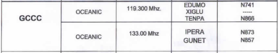](https://biblioteca.vatsimspain.es/uploads/images/gallery/2025-10/lr1image.png) Según el área, los pilotos llamarán a través de una u otra frecuencia o se les instruirá a llamar por tales. ##### 5. 2. Volumen GCCCOCE [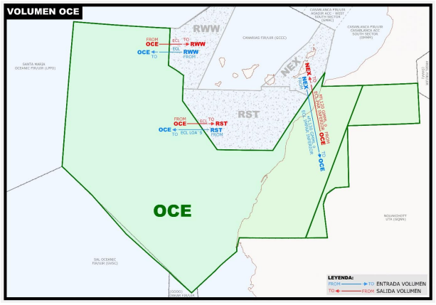](https://biblioteca.vatsimspain.es/uploads/images/gallery/2025-10/1gOimage.png) Límites verticales: MSL/FL660. Las frecuencias habituales del sector son: - 119.300 MHz. - 133.000 MHz Volúmenes colaterales: - Núcleo Ruta: RWW, RST, NEX. - Núcleo TMA: ninguno. Debido a la cobertura de frecuencias en la N741 en dirección SUR en ROSTA, se harán los cambios de frecuencia de 123.650 MHz a 119.300 MHz: [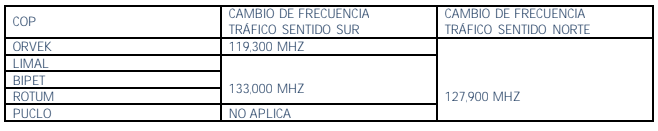](https://biblioteca.vatsimspain.es/uploads/images/gallery/2025-10/Wlcimage.png) - Normas y coordinaciones entre volúmenes. [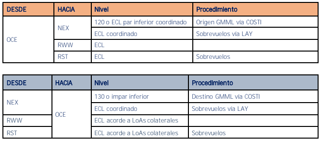](https://biblioteca.vatsimspain.es/uploads/images/gallery/2025-10/mEmimage.png) La operativa que contengan este volumen se ajustará a lo especificado en el apartado de *sectores que contengan los volúmenes RST y/o RWW y Sector OCE.* Las LoAs y [manuales de actuación](https://biblioteca.vatsimspain.es/books/fir-canarias-gccc/chapter/oceanico) con colaterales se adjuntan en el mismo apartado de Oceánico de esta Biblioteca. Su lectura es obligatoria. ##### 5. 3. Procedimientos operativos del sector y coordinaciones La transferencia del control entre sectores adyacentes dentro de la misma dependencia se realizará en el momento en el que la aeronave cruce el límite común de ambos sectores de control, si no se especifica cualquier otro punto, nivel o momento. La transferencia de comunicaciones se realizará no más tarde que la transferencia de control. Las normas y niveles de coordinación intersectorial, salvo coordinación previa, serán las especificadas a continuación. En aquellos casos en los que no se pueda cumplir con los niveles expuestos, o la coordinación no esté especificada en este documento, deberá existir una coordinación entre los sectores implicados para determinar el nivel de transferencia y cualquier otra información que se estime necesaria. Salvo coordinación en contra, los tráficos interinsulares de dirección W-E procederán a nivel de vuelo impar (se debe reflejar claramente en el ECL) y los E-W a nivel de vuelo par (se debe reflejar claramente en el ECL). Mirar punto 5.2 de este manual. Todas las aeronaves con destino a aeródromos canarios se ajustarán a las STAR o SID publicadas o vendrán autorizadas al IAF de la pista en servicio coordinado previamente, no obstante, también se podrá coordinar con sectores colaterales otros puntos de recorte previamente definidos en el AIP. En caso de cambio de pista los tráficos se encaminarán a los procedimientos STAR de la nueva pista en servicio. Se introducirá en EuroScope todo cambio significativo en el Plan de Vuelo, al objeto de garantizar la correcta generación y actualización. La operativa con tráficos VFR se completará a posterioridad en este manual. ##### 5. 4. Procedimientos de entra y salida de aeródromos de su jurisdicción**GSAI EL AAIUN (GMML) y GSVO VILLACISNEROS (GMMH) no serán controlados por GCCC bajo ninguna circunstancia en sus limites definidos. Los procedimientos específicos se detallan en la LoA entre VATSIM Spain y Maghreb vACC expandidos en el documento [*Actuación GCCC-GMMM*](https://biblioteca.vatsimspain.es/books/fir-canarias-gccc/page/actuacion-gccc-gmmm)**.
##### 5. 5. Cambios en la configuración operativa de los aeródromos de su jurisdicción. El hecho de producirse un cambio de pista en GMML o GMMH no producirá cambios específicos en la configuración de sectores. Una vez notificado por parte de una dependencia colateral la necesidad de cambiar de pista, se realizarán las acciones de coordinación pertinentes entre las dependencias afectadas. ##### 5. 6. SOP (Standard Operating Procedures) ##### 5. 6. 1. Sectores que contengan los volúmenes RST y/o RWW y sector OCE. **TRÁFICO EN SENTIDO SUR** - Los sectores que contengan RST y/o RWW serán los encargados de asignar FL finales para que antes de abandonar el sector se hayan provisto separaciones convencionales asegurándose que al abandonar el FIR/UIR Canarias cumplan con lo dispuesto en las LoAs y manuales de actuación con los FIR/UIR colaterales. - Si un tráfico informa estar equipado CPDLC, se le transmitirá que espere ese servicio en el sector OCE. - Ejemplo: **"Expect CPDLC communications in next sector"**. - Se notificará a los tráficos que el servicio radar está terminado. - 30 NM antes del límite con el sector OCE no se modificará el nivel de vuelo o ruta de los tráficos sin previa coordinación con dicho sector. **TRÁFICO TRANSFERIDO POR OCE EN SENTIDO NORTE** - Los recibe el sector que tenga el volumen RST. - Se asumirá el tráfico transferido por OCE. - Se notificará el contacto radar al tráfico. - Será el encargado de asignar FL finales para cumplir con las LoA y manuales de actuación. Deberá asegurarse de mantener separación radar con tráficos que vengan por detrás para ello, ambos tráficos deberán estar en su sector. - No se modificará el nivel de vuelo o ruta de los tráficos sin previa coordinación con RST o RWW. - Se aplicarán separaciones de tráficos al mismo FL y misma ruta que cumplan con las LoA de los colaterales en los puntos de salida de la FIR-UIR. ##### 5. 6. 2. Modo de operación en el sector OCE. - El sector OCE puede autorizar cambios de FL a las aeronaves bajo su jurisdicción, acorde a las especificaciones y limitaciones descritas a continuación. - En los apartados que siguen, se describen las acciones operativas a tomar para el manejo del Sector teniendo en cuenta el flujo temporal (discriminando entre ANTES de que las aeronaves entren en el Sector, con las aeronaves evolucionando en el Sector, y su proceso de SALIDA del mismo), las acciones necesarias para GESTION del tráfico, y las actuaciones de EuroScope necesarias. - Se hace énfasis en la necesidad de discriminar siempre si se está actuando solo sobre el Plan de Vuelo, y/o proporcionando Instrucciones de Control. - Tanto ante una elevada carga de trabajo como ante cualquier otra circunstancia que pudiese impedir la correcta evaluación del sector (a través de la bahía y la información disponible en pantalla), se evitarán los cambios de FL en el sector GCCCOCE. - Se harán chequeos frecuentes de bahía y EuroScope para tener ambas fuentes de información actualizadas en todo momento y para verificar el tráfico del sector, con especial atención en comprobar que todo vuelo esté adecuadamente representado tanto en la pantalla (según el tipo de pistas que corresponda) como en bahía (fichas de progresión de vuelo), de modo que exista una concordancia entre la situación aeronáutica resultante de ambos, así como realizar las acciones necesarias en caso contrario. Estas acciones facilitarán planificar acciones y detectar conflictos. ##### 5. 6. 3. Tráfico en corredor EUR/SAM - Discriminar el tipo de pista de que se trate: si es una traza radar, ésta pasará a ser o bien una Pista Integrada de Vigilancia (si tiene equipamiento ADS) o una pseudopista (generada automáticamente por el sistema al desaparecer la traza radar). - Verificar tipo de equipamiento y estado de conexión (ADS, CPDLC). - Se chequeará su nivel de vuelo, Ruta prevista EuroScope y embarcada (para pistas ADS el sistema muestra ambas gráficamente a petición), comunicaciones disponibles, e información existente sobre estimadas intermedias y al límite. Se corregirá o completará esta información a la mayor brevedad. Se prestará especial atención al cruce de aerovías. - Se planificarán las acciones necesarias y detectarán posibles conflictos. ##### 5. 6. 4. *Random* *Route* Oceánicos - Para tráfico Random Route que no cruza el corredor EUR/SAM; el colateral es Santa María Oceánico, y se aplicará el [*manual de actuación en vigor*](https://biblioteca.vatsimspain.es/books/fir-canarias-gccc/page/actuacion-gccc-lppo). - El tráfico *Random Route* que cruza el corredor EUR/SAM es tráfico al que hay que prestar una especial atención, debido a que cruza una o varias aerovías. - Nunca se aceptará un tráfico por encima de FL290 sin analizar el posible impacto que tendrá. En caso de no ser posible subir al tránsito, se descenderá al tránsito a FL280. - Los tráficos *RANDOM* que cruzan el corredor no tendrán prioridad en la asignación de FLs óptimos. - Se prestará, como se remarca, especial atención al cruce de aerovías. ##### 5. 6. 5. Aeronaves en el sector - Asegurar las comuncaciones. Tráfico en frecuencias VHF y dar la instrucción de mantener escucha en frecuencias de HF por voz o por mensaje CPDLC en su caso (se anotará "HF" en el campo de texto correspondiente). - Para tráfico de salida hacia SAL/Santa María se confirmarán estimadas intermedias y al límite del sector y número de MACH vía voz o CPDLC. - Se realizará un seguimiento de la situación aeronáutica usando toda la información disponible. - Se deberán revisar todos los tráficos con salida por GUENT, y aquellos cuya ruta continúe en el espacio aéreo de DAKAR deberán ser coordinados, además de con SAL Control con DAKAR ACC. - Se establecerá separación con otros tráficos por métodos de Control Convencional. Todos los tráficos al oeste de la aerovía N741 con Santa María fuera del corredor deben mantener separación vertical por FL si su ruta no es compatible. - Cuando la recepción o transmisión vía HF sea defectuosa se evitará expedir autorizaciones de cambio de nivel por ese medio. - Se se realizase algún cambio de FL se actualizará este en EuroScope. Se coordinará el cambio de FL si este pudiera afectar a tráficos posteriores de los sectores RST y RWW. - Para tráfico en sentido sur, por *[manual de actuación GCCC-GVSC](https://biblioteca.vatsimspain.es/books/fir-canarias-gccc/page/actuacion-gccc-gvsc)* 5 minutos antes de la frontera con SAL no se cambiará FL a menos que sea debido a situaciones especiales (por ejemplo: emergencias, fuertes turbuencias, etc) teniendo estos casos que ser coordinados con SAL Control. - En caso de notificar un piloto que no tiene equipo HF y tendría que ser desviado fuera del área donde es requerido este equipamiento (por ejemplo, hacia GUNET). ##### 5. 6. 6. Salida del sector. - Comprobación de que se tiene la información necesaria (informes de posición, nivel de vuelo, estimadas al límite). - Comprobar que se ha proporcionado al tráfico las frecuencias propias para notificar la salida del FIR (VHF, HF) y las del colateral, especial precaución si no hay conexión CPDLC. - Si el tráfico va a transferirse a los sectores RST o RWW, verificar que se ha correlado la etiqueta antes de transferirlo. - Para vuelos salientes veritificar que el tráfico se entrega en cumplimiento de la Carta de Acuerdo o manual de actuación correspondiente. - Para vuelos de salida a colaterales, verificar que la estimada se ha comunicado correctamente, ya sea por *OLDI* (simulado a través de *.chat*) o por voz (a través de VCCS). Se se requiere algún FL una vez pasada la estimada, deberá ser coordinado y aceptado por el receptor y actualizado en EuroScope. - Comprobar el cambio de estado/cancelaciónd e pistas y sistemas (fin de conexiones CPDLC, ADS, cancelación de pseudopistas). ##### 5. 6. 7. Tráfico sin comunicación en la frontera. - Dada la pobre cobertura radio VHF al sur del FIR, es frecuente no recibir llamadas en dichas frecuencias. Las aeronaves intentarán contactar por otros medios disponibles (HF y/o CPDLC). - Si a 5 minutos después de la estimada al punto de entrada no se ha conseguido establecer contacto, se coordinará con HF para que intente comunicar con la aeronave vía SELCAL. - Si no se consigue contacto, se debe informar a SAL, si disponible, de dicha circunstancia y confirmar el paso de puntos, así como solicitar que intente contactar con la aeronave en sus frecuencias. - Se intentará contactar, mediante llamadas en frecuencias de emergencia, con *relay* de otra aeronave, etc. . - Si se consiguiera contacto se da respondedor (si fuera necesario, vía HF) y se confirmarán frecuencias. ##### 5. 6. 8. Tráfico que vuela directo de ROSTA a KONBA. Además de las consideraciones recogidas anteriormente, para los tráficos que procedan por la ruta ROSTA-KONBA también se aplicará la siguiente operativa: - Todos los tráficos deberán estar equipados ADS/CPDLC. - En el momento de recibir una estimada de LPPO de un vuelo con esa ruta, se coordinará lo antes posible con GCCCNWW, si la hubiese, para verificar que no hay tráfico sentido sur a esa nivel de entrada por NELSO. En caso de haberlo se deberá cambiar nivel a uno de los dos tráficos para proporcionar separación vertical. - Tanto ante una elevada carga de trabajo, como ante cualquier otra circunstancia que pudiese impedir la correcta monitorización y planificación del sector, se evitarán los cambios de FL los vuelos en la ruta ROSTA-KONBA hasta estar en contacto radar dentro del volumen RNW o quien lo abarque. El cambio de FL será realizado por el sector que sea responsable de dicho volumen. - Si debido a una elevada de tráfico o a cualquier causa que lo sugiera se considera necesario, se coordinará con LPPT la no aceptación de tráficos por NELSO al nivel de vuelo del tráfico que realiza la ruta directa ROSTA-KONBA. ##### 5. 6. 9. Tráfico en el Sáhara Occidental. - Tráfico que puede ser de especial complejidad, el foco ha de ser la información disponible (Ruta, coordenadas, estimadas, equipamiento...) y generación de pseudopistas. - Los procedimientos para entrar al sector serán los mismos que se establecen en los puntos 5.6.1 y punto 5.6.2 de este manual. - Para aeronaves que se encuentran en el sector, es procederá con lo establecido en los puntos 5.6.1 y punto 5.6.2 de este manual además de lo siguiente: - Se establecerá separación con otros tráficos por métodos de Control Convencional. El cambio a FL pares se realizará lo posible en zona de cobertura radar. - Tráfico que entran al sector OCE en sentido sur a través del Sáhara Occidental y vayan a incorporarse al corredor, en la asignación de FL par final, no tendrá prioridad frente al tráfico que vuela en aerovía por el corredor. Si se quisiera asignar un FL par antes de incorporarse al corredor, se deberá coordinación con el sector RST o equivalente, si los hubiesen. - Se prestará especial atención a las aerovías bidireccionales. Para el caso de tráficos hacia el norte, verificar que el sistema procede a su correlación. - Se anotará en ficha o cualesquiera medios disponibles la hora de llamada. - Se le proporcionará frecuencias de HF a todos los tráficos (también a los conectados CPDLC para el caso de pérdida de contacto). Se anotará "HF" en el campo de texto disponible. - Se confirmarán estimadas (intermedias y a límite del Sector) vía voz o CPDLC, y se actualizará el FPL en EuroScope. - Para el paso de estimadas, se aplicará la operativa habitual con la dependencia aceptante a través de *OLDI* (simulado a través del comando .chat) o a través de *VCCS*. - Se recomienda al CTA que, en la medida de lo posible, al tráfico que vuele la STAR COSTI\*C se le autorice directo a ENETA y se modifique su FPL. De este modo se evita pasar por CANIS y los posible conflictos en AC y NE. - Los tráficos que procedan por las aerovías G581/N728 procederán como sigue: - A nivel impar cuando vuelan hacia el SE. - A nivel par cuando vuelan hacia el NW (se considera que en esta aerovía prima más la orientación N-S). - Los tráficos que procedan por la W/Q-279 (origen o destino GMML) procederán: - A nivel impar cuando vuelan hacia el SE. - A nivel par cuando vuelan hacia el NW (se considera que en esta aerovía prima más la orientación E-W) - Se aplicará *[LoA con Casablanca](https://archivos.vatsimspain.es/Operaciones/LOAs/Maghreb/LoA_Maghreb.pdf)* y *[Actuación GCCC-GMMM](https://biblioteca.vatsimspain.es/books/fir-canarias-gccc/page/actuacion-gccc-gmmm)* según corresponda. Se pasarán a Casablanca estimadas de tráficos con destino GMML y GMMH operando de esta manera: - Arribadas a GMMH/GMML: se pasará la estimada a GMMM en descenso a FL100. Una vez separadas las ARR de todos los tráficos por encima de FL195, se les dará información de tráfico hasta FL100 antes de ser transferidas. También se les dará información de tráfico conocido por debajo de FL100 si el CTA considera que esta información es relevante para la ARR. - Despegues de GMMH/GMML. Se les informará del tráfico conocido hasta FL195 y por encima de ese nivel se les autorizará el ascenso hasta el nivel requerido asegurando la separación con el resto de los tráficos por encima de FL195.La LoA actual con Maghreb vACC establece que los tránsitos serán descendidos a FL130 a GMML. En la medida de lo posible, se coordinará con GMMM que las salidas sean subidas a FL090 mientras que las llegadas serán descencidas a FL100. En el caso de GMMH se seguirá la misma operativo. En el caso de que GMMM considere ceñirse a la LoA, se proseguirá como sigue.
**La Altitud de Transición publicado por Casablanca en esas zonas, GMML y GMMH, es de 3000 pies.**
- - - Es importante pedir estimadas completas incluso a destino para evitar *INCERFA* en tráficos sque entren en Mauritania que vuelen bajos o tengan destinos dentro del Sáhara. - Si se realizase algún cambio de FL se actualizará en EuroScope. - Para las salidas del sector se procederá como sigue: - Se verificará que el tráfico está respondiendo el código SSR correcto en tráfico hacia el norte. - Se verificará que el tráfico se entrega en cumplimiento de la Carta de Acuerdo con Casablanca ACC y el *manual de Actuación GCCC-GMMM.* ##### 5. 6. 10. Rally (agrupación de vuelos VFR) en el desierto A pesar de que la coordinación correcta de estos casos prevé que con antelación suficiente, GCCC debe disponer de todos los datos de los participantes en estos eventos, en el caso de que nos encontremos en tiempo real con uno de ellos sin que esa coordinación previa haya tenido lugar se procederá según se recoge a continuación.**Nota:** **a las altitudes a las que tienen lugar estas actividades, las aerovías en el SÁHARA en el FIR Canarias son F, y fuera de ellas son G. En ambas clases, los VFR no tienen obligación de comunicar radio con la dependencia ATS ([ENR-1.4](https://aip.enaire.es/aip/contenido_AIP/ENR/LE_ENR_1_4_en.pdf)).**
- Intentar coordinar mediante un líder que se haga cargo de transmitir la información a los demás componentes del rally. En caso de logarlo, solicitarle la siguiente información y saltar al punto 4: - Número total de aeronaves. - Estimada del grupo a destino (sería suficiente con la hora estimada del primera y del último en llegar). - Recopilar las estimadas que nos pase el colateral (si vienen de otro FIR) o la TWR (si despegan dentro de nuestro espacio aéreo), solicitando indicativo y estimada a destino. Solicitar si dispone del número total de aeronaves. - Recopilar indicativo y estimada a destino de aquellos que nos llamen en el aire, y si no hemos conseguido antes la información, solicitarle que indique número total de aeronaves participantes en la actividad. - Pasar los datos obtenidos de las acciones del punto 1, o en su defecto los de los puntos 3 y 4 al siguiente colateral (o a la TWR de destino si se encontrara en nuestro espacio aéreo. - La operativa en el sector GCCCOCE será: - No hay obligatoriedad de llamar a ningún tráfico por iniciativa propia. - Cuando nos llame uno de los VFR se le contesta. - Si estamos ocupados: *standby*. - Cuando el resto del tráfico lo permita, llamamos al tráfico que nos había llamado: por su indicativo si pudimos entenderlo y si no, mediante *station calling, go ahead now*. Si no nos responde, no deberemos hacer nada más. Si nos responde, procedemos de la manera siguiente: - Si podemos atenderle: - Copiamos la información que nos transmita, prestando atención al indicativo y estimada al destino. - Daremos información de tráfico a requerimiento (la referente al propio rally se dará de manera genérica y no uno a uno). - Se determinará a propia discreción si los planes de vuelo se introducen en EuroScope o si se toma nota de ellos. ##### 5. 6. 11. Gestión de tráfico en el pasillo GDV/GCLP - COSTI Los tráficos entre GCLP/GDV y LAY se gestionarán de la siguiente manera: **Arribadas a GCLP: LAY - COSTIxC**: - Para despegues de GMML, OCE dará al despegue información de tráfico hasta FL120 o hasta nivel par coordinado con NEX. - OCE transferirá el tráfico a NEX en las inmediaciones de COSTI. - NEX asignará nivel par final al tráfico y lo introducirá en el ECL. - NEX transferirá el tráfico a Gran Canaria Aproximación establecido a nivel par si está por debajo de FL130 o en descenso para FL130 si viene más alto. **Despegue de GCLP vía COSTI:** - Aproximación Gran Canaria subirá el tráfico a FL110 o nivel impar coordinado con NEX. - Una vez el despegue esté libre del resto de tráficos, Gran Canaria aproximación lo transferirá a NEX. - NEX asignará nivel final y lo introducirá en el ECL. Para arribadas a GMML, el nivel será impar. Para sobrevuelos por LAY el nivel final deberá ser coordinado con OCE, dependiente de la ruta. Después de LAY o del tráfico que esté gestionando el sector OCE. - En ecaso de arribadas a GMML con ECL por encima de FL130, NEX transferirá en descenso a FL130. En las inmediaciones de COSTI, NEX dará "SERVICIO RADAR TERMINADO" y lo transferirá a OCE. **Sobrevuelos por la Q279/W279 (GDV-COSTI-LAY):** Los niveles de transferencia definidos en los puntos anteriores para arribadas y despegues son los generales. Como en el resto de TFL, se podrán coordinar niveles de transferencia diferentes si las condiciones operativas o de seguridad así lo requieren. - **Volumetría de los sectores:** [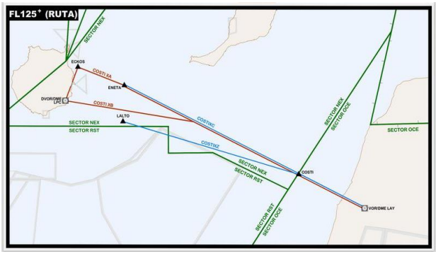](https://biblioteca.vatsimspain.es/uploads/images/gallery/2025-10/uTQimage.png) [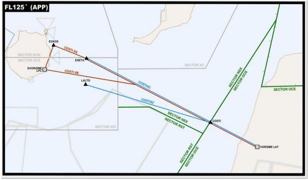](https://biblioteca.vatsimspain.es/uploads/images/gallery/2025-10/jPVimage.png) - - ***Definición de TFL.*** Están definidos en base de datos los siguientes TFL entre sectores en DEPs y ARRs: - DEP GCLP vía COSTI: Gran Canaria Aproximación a NEX: TFL - FL110. - ARR GCLP vía COSTI: NEX a Gran Canaria Aproximación: TFL - FL130. - DEP GMML vía COSTI: OCE a NEX: TFL - FL120. - ARR GMML vía COSTI: NEX a OCE: TFL - 130. #### **6. Coordinaciones** ##### 6. 1. Con dependencias ATS colaterales Las condiciones de transferencia y distintos acuerdos entre dependencias podrán consultarse a través del libro ***[FIR CANARIAS (GCCC)](https://biblioteca.vatsimspain.es/books/fir-canarias-gccc)*** ##### 6. 2. Con COM/AIS **Plan de Vuelo AFIL**Un **plan de vuelo AFIL** (del inglés *Air Filed Flight Plan*) es un **plan de vuelo que se presenta en vuelo**, es decir, después de que la aeronave ya ha despegado.
En el caso de recibir en frecuencia la solicitud de Plan de Vuelo AFIL el controlador deberá recopilar la siguiente información: - **Plan de Vuelo AFIL bajo reglas IFR**: - Indicativo. - Tipo de aeronave. - Aeródromo de salida. - Punto de notificación de entrada, hora estimada y nivel de vuelo. - Ruta. - Aeródromo de destino. - **Plan de Vuelo AFIL bajo reglas VFR:** - Indicativo. - Tipo de aeronave. - Aeródromo de salida. - Punto de notificación de entrada, hora y altitud/nivel de vuelo. - Aeródromo de destino. - Aeródromo o lugar de operaciones alternativa. - Tiempo estimado de arribada. - Personas a bordo. - Autonomía. El controlador introducirá los datos en en EuroScope: - **Cambio de destino:** - Plan de Vuelo IFR: cuando un controlador reciba en frecuencia un mensaje de cambio de destino asociado a un plan de vuelo IFR ya existente, se procederá de la siguiente forma: - El controlador introducirá el nuevo destino y ruta en EuroScope asegurando de introducir lo solicitado correctamente. - El controlador coordinará con las dependencias afectadas. - Sea cual fuere el destino (nacional/internacional) antes de aceptar un cambio de destino, se deberá coordinar con todas las dependencias afectadas. #### **7. Procedimientos locales** ##### 7. 1. Procedimientos para vuelos de calibración. Para los vuelos de calibración de las radioayudas tanto del entorno aeroportuario como fuera de él con carácter general, el CTA dispondrá de la informacion sobre horarios, radioayudas, procedimientos a utilizar y asesoramiento que se le proporcionará. Será imperativo el reporte de intenciones por parte del tránsito. ##### 7. 2. Procedimientos para vuelos de entrenamiento. Prioridades ante la petición de un tráfico en entrenamiento. - **Vuelos de entrenamiento con coordinación previa (táctica)**: - Se seguirá lo dispuesto en el procedimiento coordinado y autorizado por la Divisón ATS. - El procedimiento deberá contener: - Descripción de la maniobra. - Coordinaciones. - Fecha y hora prevista de la maniobra. - Otra información que se considere necesaria. - En táctica, dicha autorización podrá modificarse, posponerse o cancelarse si tuviese afección operativa significativa sobre otras aeronaves previa valoración por el controlador. - **Vuelo de entrenamiento sin coordinación previa:** - Ante la petición de un tráfico en entrenamiento de realizar varias o diferentes aproximaciones a un aeródromo, el controlador de aproximación informará siempre a todas las dependencias implicadas. - Pese a no existir una autorización previa, se intentará facilitar dicha petición, en la medida de lo posible, con una previa evaluación del impacto operativo, evitando cualquier demora para el resto del tráfico y no teniendo el vuelo de entrenamiento prioridad alguna. - Si en el momento de la petición no se puede facilitar la maniobra por el volumen de tráfico existente, pero se prevé que podrá facilitarse más tarde, se informará al tráfico de la situación, facilitándole una espera y una estimada aproximada para el posible inicio de su maniobra. - Si el tráfico pidiese toma final se le incorporará a la secuencia conforme a la menor demora media. ##### 7. 3. Uso del CPDLC.****CPDLC (*Controller–Pilot Data Link Communications*)**** es un sistema de comunicación aeronáutica por enlace de datos que permite el intercambio bidireccional de mensajes de texto estructurados entre pilotos y controladores de tráfico aéreo, complementando o reemplazando las comunicaciones por radio VHF/HF en entornos de alta densidad o larga distancia, mejorando la seguridad, eficiencia y claridad en la gestión del tráfico aéreo**. En VATSIM se utilizará [Hoppie CPDLC](http://hoppie.nl/).**
**El CPDLC no estará disponible por debajo de FL285.**
[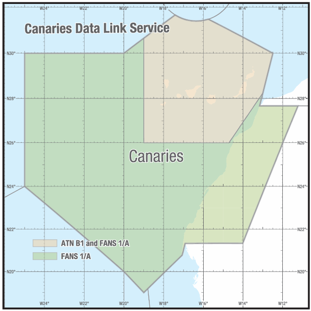](https://biblioteca.vatsimspain.es/uploads/images/gallery/2025-10/ocyimage.png)| **POSICIÓN** | **CÓDIGO** |
| GCCO\_FSS | CCRO |
**La lectura de las Cartas de Acuerdo junto a los [manuales de actuación de GCCC con dependencias colaterales](https://biblioteca.vatsimspain.es/books/fir-canarias-gccc/chapter/oceanico) es obligatoria antes de conectarse en Canarias Control.**
> [España - Maghreb](https://archivos.vatsimspain.es/Operaciones/LOAs/Maghreb/LoA_Maghreb.pdf "España - Maghreb") > [España - Portugal](https://archivos.vatsimspain.es/Operaciones/LOAs/Portugal/LoA_Portugal.pdf "España - Portugal") > [España - vRAF](https://archivos.vatsimspain.es/Operaciones/LOAs/vRAF/vRAF_VATSPA_LOA_V1.11.pdf) --- ##### INFORMACIÓN ADICIONALSi has encontrado información errónea en esta página o hay algo que crees que podrías mejorar, comunícalo por [email a operaciones](https://vatsimspain.es/staff).
**Log de versiones (ACCSP54)** 1558357 - Redacción inicial. (13/07/2024) **(ACCSP57)** 1513609 - Ampliación y estructuración de Manual Operativo (15/10/2025).
# Actuación GCCC-GMMM #### **GENERALIDADES** ##### **1. Propósito:** El propósito de esta documento es definir y ampliar los procedimientos de coordinación que deben aplicarse entre el Centro de Control de Área de Casablanca y el Centro de Control de Área de Canarias, resumen de la *[LoA entre GCCC y GMMM](https://archivos.vatsimspain.es/Operaciones/LOAs/Maghreb/LoA_GCCC-GMMM.pdf)* al proporcionar los Servicios de Tránsito Aéreo (ATS) al Tráfico Aéreo General (IFR/VFR). Estos procedimientos son complementarios a los especificados en los documentos de la OACI, EUROCONTROL y/o en los documentos nacionales. ##### **1. 2. Estatus operacional:** Ambas ATSU deberán mantener coordinación constante, y en especial, el controlador o conjunto de controladores del ACC de Canarias sobre cualquier cambio en el estado operativo de sus operaciones y ayudas a la navegación que pueda afectar a los procedimientos entre ambos ACCs. ##### **ÁREAS DE RESPONSABILIDAD PARA LA PRESTACIÓN DE ATS.** ##### **2. 1. Área de Responsabilidad:**| **Sector/COPs** | **Mensaje** | **Herramienta** |
| COPs | Datos de Plan de Vuelo y Estimadas | VCCS *Data Line (OLDI)\*\** |
| **KORAL** **SOLNA** **ECHED** | **Mensajes de control** **Acelerar autorizaciones** **Solicitudes de aprobación** **Revisiones** **Datos del plan de vuelo** **Otra coordinación** |
| **Sector/COPs** | **COPs** | **Mensaje** | **Herramienta** |
| **NEX** **(NORESTE)** **NEL** **(NORESTE BAJO)** | **DEVLA** **RUSIK** | **Datos de Plan de Vuelo y Estimadas** | VCCS *Data Line (OLDI)\*\** |
| **OCE** **(OCEANIC SECTOR)** | **SOLNA** **ECHED** | **Mensajes de control** **Acelerar autorizaciones** **Solicitudes de aprobación** **Revisiones** **Datos del plan de vuelo** **Otra coordinación** |
Si has encontrado información errónea en esta página o hay algo que crees que podrías mejorar, comunícalo por [email a operaciones](https://vatsimspain.es/vacc/staff/).
**Log de versiones** 1513609 - Creación de Manual de Actuación GCCC-GMMM (15/10/2025).
# Actuación GCCC-LPPO #### **GENERALIDADES** ##### **1. Propósito:** El propósito de esta documento es definir y ampliar los procedimientos de coordinación que deben aplicarse entre el Centro de Control de Área de Santa María y el Centro de Control de Área de Canarias, complementario a la *[LoA entre Canarias y Santa María OAC](https://archivos.vatsimspain.es/Operaciones/LOAs/Portugal/LoA_Portugal.pdf)* al proporcionar los Servicios de Tránsito Aéreo (ATS) al Tráfico Aéreo General (IFR/VFR). Estos procedimientos son complementarios a los especificados en los documentos de la OACI, EUROCONTROL y/o en los documentos nacionales. ##### **1. 2. Estatus operacional:** Ambas ATSU deberán mantener coordinación constante, y en especial, el controlador o conjunto de controladores del ACC de Canarias sobre cualquier cambio en el estado operativo de sus operaciones y ayudas a la navegación que pueda afectar a los procedimientos entre ambos ACCs. ##### **ÁREAS DE RESPONSABILIDAD PARA LA PRESTACIÓN DE ATS.** ##### **2. 1. Área de Responsabilidad:**Si has encontrado información errónea en esta página o hay algo que crees que podrías mejorar, comunícalo por [email a operaciones](https://vatsimspain.es/vacc/staff/).
**Log de versiones** 1513609 - Creación de Manual de Actuación GCCC-LPPO (15/10/2025).
# Actuación GCCC-GVSC ##### **GENERALIDADES** ##### **1. Propósito:** El propósito de esta documento es definir los procedimientos de coordinación que deben aplicarse entre el Centro de Control de Área de Canarias y el Centro de Control de Área de Sal. No existen LoAs definidas entre VATSIM España y VATSSA por lo que este documento servirá como manual de operación. Estos procedimientos son complementarios a los especificados en los documentos de la OACI, EUROCONTROL y/o en los documentos nacionales. ##### **1. 2. Estatus operacional:** Ambas ATSU deberán mantener coordinación constante, y en especial, el controlador o conjunto de controladores del ACC de Canarias sobre cualquier cambio en el estado operativo de sus operaciones y ayudas a la navegación que pueda afectar a los procedimientos entre ambos ACCs. ##### **ÁREAS DE RESPONSABILIDAD PARA LA PRESTACIÓN DE ATS.** ##### **2. 1. Área de Responsabilidad:**| **TCP** | **ID Sector** | **Mensaje** | **Herramienta** |
| **EDUMO** | **SAL OCEÁNICO** | **Datos de Plan de Vuelo y Estimadas, Mensajes de Control y Revisiones.** | **VCCS** ***Data Link (OLDI)*** |
| **XIGLU** | **SAL OCEÁNICO** | ||
| **TENPA** | **SAL OCEÁNICO** | ||
| **IPERA** | **SAL OCEÁNICO** | ||
| **GUNET** | **SAL OCEÁNICO** |
| **Sector receptor/COPs** | **Mensaje** | **Posición** | **Herramienta** |
| **Sector Oceánico (OCE)** | **Datos de Plan de Vuelo y Estimadas** | **VCCS** ***Data Link (OLDI)*** | |
| **XIGLU** **EDUMO** **TENPA** **IPERA** **GUNET** | **Mensajes de control** **Acelerar autorizaciones** **Solicitudes de aprobación** **Revisiones** **Datos del plan de vuelo** **Otra coordinación** | **Según sectorización** | |
| **Coordinación Radar** | **N/A** | ||
| **FIC** | **Datos de Plan de Vuelo y otra Coordinación** |
Si has encontrado información errónea en esta página o hay algo que crees que podrías mejorar, comunícalo por [email a operaciones](https://vatsimspain.es/vacc/staff/).
**Log de versiones** 1513609 - Creación de Manual de Actuación GCCC-GVSC (15/10/2025).
# Actuación GCCC-GQPP ##### **GENERALIDADES** ##### **1. Propósito:** El propósito de esta documento es definir los procedimientos de coordinación que deben aplicarse entre el Centro de Control de Área de Canarias y Nouadhibou Aproximación. No existen LoAs definidas entre VATSIM España y VATSSA por lo que este documento servirá como manual de operación. Estos procedimientos son complementarios a los especificados en los documentos de la OACI, EUROCONTROL y/o en los documentos nacionales. ##### **1. 2. Estatus operacional:** Ambas ATSU deberán mantener coordinación constante, y en especial, el controlador o conjunto de controladores del ACC de Canarias sobre cualquier cambio en el estado operativo de sus operaciones y ayudas a la navegación que pueda afectar a los procedimientos entre ambos ACCs. ##### **ÁREAS DE RESPONSABILIDAD PARA LA PRESTACIÓN DE ATS.** ##### **2. 1. Área de Responsabilidad:**| **Sectores receptores/COPs** | **Mensaje** | **Herramienta** |
| **LOLOS** | **Mensajes de control** **Acelerar autorizaciones** **Solicitudes de aprobación** **Revisiones** **Datos del plan de vuelo** **Otra coordinación** | **VCCS** |
| **Sectores Receptores/COPS** | **Mensaje** | **Posición** | **Herramienta** |
| **SECTOR OCÉANICO (OCE)** **COP: LOLOS** | **Mensajes de control** **Acelerar autorizaciones** **Solicitudes de aprobación** **Revisiones** **Datos del plan de vuelo** **Otra coordinación** | **Según sectorización** | **VCCS** |
Si has encontrado información errónea en esta página o hay algo que crees que podrías mejorar, comunícalo por [email a operaciones](https://vatsimspain.es/vacc/staff/).
**Log de versiones** 1513609 - Creación de Manual de Actuación GCCC-GQPP (15/10/2025).
# Actuación GCCC-GQNO ##### **GENERALIDADES** ##### **1. Propósito:** El propósito de esta documento es definir los procedimientos de coordinación que deben aplicarse entre el Centro de Control de Área de Canarias y el Centro de Control de Área de Nouakchott. No existen LoAs definidas entre VATSIM España y VATSSA por lo que este documento servirá como manual de operación. Estos procedimientos son complementarios a los especificados en los documentos de la OACI, EUROCONTROL y/o en los documentos nacionales. ##### **1. 2. Estatus operacional:** Ambas ATSU deberán mantener coordinación constante, y en especial, el controlador o conjunto de controladores del ACC de Canarias sobre cualquier cambio en el estado operativo de sus operaciones y ayudas a la navegación que pueda afectar a los procedimientos entre ambos ACCs. ##### **ÁREAS DE RESPONSABILIDAD PARA LA PRESTACIÓN DE ATS.** ##### **2. 1. Área de Responsabilidad:** ****ACC CANARIAS**** - **Límites laterales:** - Los límites laterales de la FIR/UIR CANARIAS según lo publicado en el [AIP España ENR 2.1.](https://aip.enaire.es/aip/contenido_AIP/ENR/LE_ENR_2_1_en.pdf) - **Límites verticales:** - FIR: SFC/FL195. - UIR: FL195/UNL. - La clasificación del espacio aéreo OACI correspondiente al área de responsabilidad del ACC de Canarias, a lo largo del límite común entre el área de responsabilidad del ACC de Canarias y el ACC de Nouakchott, se describe en el Anexo B de este documento. **UTA NOUKCHOTT** - **FIR: GND/MLS-FL245.** - **UIR: FL245-UNL.** - **Límites laterales:** - 27° 40'N - 008°40'W 27° 40'N - 011°14'W 25° 39'N - 012°09'W 21° 20'N - 016°52'26"W 20° 47'N - 017°04'W 19° 20'N - 018°45'W 16° 37'N - 018°31'W desde 16° 37'N - 018°31'W, un arco de círculo de radio 120 NM centrado en el punto ANITI, hasta el punto: 16° 29'N - 016°18'W - Asimismo, los límites territoriales de SENEGAL y MAURITANI**A** hasta el punto: 14° 45'N - 012°26'W 15° 18'N - 011°49'W 16° 15'N - 011°35'W 16° 21'N - 003°36'W 24° 20'N - 008°40'W 27° 40'N - 008°40'W - La clasificación OACI para el área de responsabilidad de Nouakchott ACC junto al límite común de las áreas de responsabilidad de Canarias ACC y Nouakchott ACC se describe en el Anexo B de este documento. ##### **2. 2. Delegación de responsabilidad para la prestación ATS.** No aplica (mírese *[Actuación GCCC-GQPP](https://biblioteca.vatsimspain.es/books/fir-canarias-gccc/page/actuacion-gccc-gqpp)* ). ##### **2. 3. Prestaciones especiales:** No aplica. ##### **PROCEDIMIENTOS** ##### **3. 1. Procedimientos específicos:** Los procedimientos que deben aplicar el ACC de Canarias y el ACC de Nouakchott se detallan en los Anexos de esta documento: **Anexo A:** Definiciones y Abreviaturas. **Anexo B:** Área de Interés Común. **Anexo C:** Intercambio de Datos de Vuelo. **Anexo D:** Procedimientos de Coordinación. **Anexo E:** Transferencia de Control y Transferencia de Comunicaciones. ##### **3. 2. Procedimientos específicos:** Estos procedimientos deberán ser difundidos al personal operativo de las unidades ATS implicadas de VATSIM España. ##### **REVISIONES Y DESVIACIONES** ##### **4. 1. Revisión de los Anexos de este documento:** La revisión de los Anexos de este documento estará a cargo del Departamento de Operaciones - División de Documentación y estará basada tanto en lo previsto o documentado por el Departamento de Operaciones. Siempre prevalecerá por orden jerárquico: - Lo publicado en el AIP y - Finalmente, este documento junto a los procedimientos locales del vACC publicados en esta Biblioteca. ##### **4. 2. Desviaciones temporales:** Cuando sea necesario, los responsables de los Departamentos de Operaciones podrán introducir, bajo acuerdo previo y por un periodo de tiempo específico, modificaciones temporales a los procedimientos que conciernen a ambos vACCs. ##### **4. 3. Desviaciones incidentales:** Pueden surgir situaciones en las que se hagan desviaciones incidentales de los Procedimientos Especificados en los Anexos de este documento. En estas circunstancias, se espera que los controladores ejerzan su mejor juicio para garantizar la seguridad y eficiencia del tráfico aéreo. ##### **INTERPRETACIÓN Y SOLUCIÓN DE CONTROVERSIAS** En caso de surgir alguna duda o discrepancia respecto a la interpretación de cualquier disposición de este documento o en caso de disputa sobre su aplicación, las controladores del ACC de Canarias consultarán con el Departamento de Operaciones sus dudas y desacuerdos para que, si proceden, puedan ser elevadas a instancias superiores. ##### **VALIDEZ** La validez de este documento tendrá vigencia en la medida que este documento esté publicado por los medios de documentación públicas de VATSIM Spain. Se recomienda a los controladores revisar constantemente este documento antes de abrir cualquiera de las dependencias en GCCC. ##### **ANEXO A:** ***ABREVIATURAS*** ##### **[](https://biblioteca.vatsimspain.es/uploads/images/gallery/2025-10/ezFimage.png)** ##### **ANEXO B:** ***Área de Interés Común*** ##### **B.1. Estructura y Clasificación del Espacio Área de Interés Común.** - ***GCCC FIR / UIR. AIP SPAIN ENR 2.1.1. y ENR 2.1.3.*** [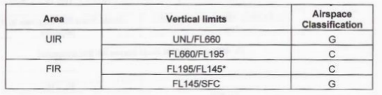](https://biblioteca.vatsimspain.es/uploads/images/gallery/2025-10/UPiimage.png) *\* Un área específica está definida en el AIP ESPAÑA ENR 2.1.3, donde la clasificación del espacio aéreo desde el nivel de vuelo FL145 hasta FL195 es “G” (zona del Sahara), en lugar de “C”.* - ***GQNO UTA. AIP ASECNA 11 ENR 2-1-01*** [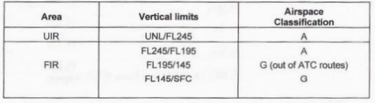](https://biblioteca.vatsimspain.es/uploads/images/gallery/2025-10/3Mmimage.png) ##### **B.2. Espacio aéreo AFI RVSM.** - El espacio aéreo de la Región AFI entre los niveles de vuelo FL290 y FL410 inclusive, que abarca todas las **FIR** de la Región AFI, es el espacio aéreo RVSM designado de la AFI. - No existe espacio aéreo de transición en el espacio aéreo RVSM de la AFI. ##### **B.3. Procedimientos para el espacio aéreo AFI RVSM.** Los procedimientos RVSM aplicables en el espacio aéreo RVSM de la Región AFI se encuentran en el [Reglamento de Procedimientos Suplementarios - Doc. 7030/4 - Región del Océano Índico Africano](https://www.ocean360training.com/file/si1033745/ICAO%20Document%207030-fi17615237.pdf). Los procedimientos detallados se incluyen en el Manual de Operaciones de ATC para RVSM en la Región AFI. Las aeronaves compatibles con RVSM y las aeronaves no compatibles con RVSM que ingresen al espacio RVSM deberán formar un espacio aéreo no RVSM en un nivel de vuelo de acuerdo con la [Tabla de Niveles de Crucero de la OACI, publicada en el Anexo 2, Apéndice 3(a) de la OACI.](https://www.pilot18.com/wp-content/uploads/2017/10/Pilot18.com-ICAO-Annex-2-Rules-of-air.pdf) La siguiente tabla contiene los niveles de vuelo RVSM aplicables en el espacio aéreo RVSM de la Región AFI. [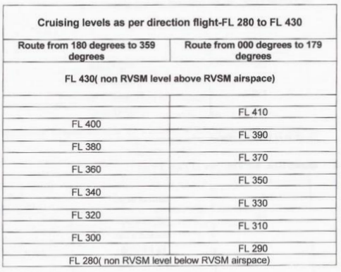](https://biblioteca.vatsimspain.es/uploads/images/gallery/2025-10/LzOimage.png) ##### **B.4. Operaciones de vuelo dentro del espacio aéreo RVSM de la Región AFI** Excepto para las aeronaves estatales según lo definido en el [Artículo 2 de la Convención de Chicago (Doc. 7333)](https://treaties.un.org/doc/publication/unts/volume%2015/volume-15-ii-102-english.pdf), solo las aeronaves aprobadas para RVSM estarán autorizadas para operar dentro del espacio aéreo RVSM de la Región AFI. ##### **B.5. Procedimientos de contingencia para el aumento de separación** Una unidad correspondiente considerará aumentar la separación vertical dentro de las áreas afectadas de su espacio aéreo RVSM de la FIR cuando haya informes de pilotos de turbulencia mayor que moderada. En áreas donde se informe de turbulencia significativa, se aumentará el mínimo de separación vertical entre todas las aeronaves. ##### **APÉNDICE 1 DEL ANEXO B** ***Área de Interés Común*** [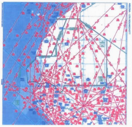](https://biblioteca.vatsimspain.es/uploads/images/gallery/2025-10/AzSimage.png) ##### **ANEXO C** ***Intercambio de Datos de Vuelo*** ##### **C. 1. Coordinaciones** Los mensajes de coordinación compartidos entre ATSUs deberán contener lo siguiente: [](https://biblioteca.vatsimspain.es/uploads/images/gallery/2025-10/xVXimage.png) ##### **C. 2. Coordinaciones verbales** ***Mensajes de Canarias ACC a Nouakchott ACC***| Sector receptor/COPs | Mensaje | Herramienta |
| **Nouakchott Control** | **Datos de Plan de Vuelo y Estimadas** | VCCS |
| **MIYEC** **GUPEL** **PE** **CARIM** **NOCUT** | **Mensajes de control** **Acelerar autorizaciones** **Solicitud de aprobación** **Revisiones** | |
| **Coordinación radar** | ||
| **FIC** | **Datos de Planes de Vuelo y otras coordinaciones** |
| Sector receptor/COPs | Mensaje | Herramienta |
| **Sector Oceánico (OCE)** | **Datos de Plan de Vuelo y Estimadas** | VCCS |
| **MIYEC** **GUPEL** **PE** **CARIM** **NOCUT** | **Mensajes de control** **Acelerar autorizaciones** **Solicitud de aprobación** **Revisiones** | |
| **Coordinación radar** | ||
| **FIC** | **Datos de Planes de Vuelo y otras coordinaciones** |
Si has encontrado información errónea en esta página o hay algo que crees que podrías mejorar, comunícalo por [email a operaciones](https://vatsimspain.es/vacc/staff/).
**Log de versiones** 1513609 - Creación de Manual de Actuación GCCC-GQNO (15/10/2025).
| Sector receptor/COPs | Mensaje | Herramienta |
| **Oceanic Sector (OCE)** **GUNET** | **Datos de Plan de Vuelo y Estimadas** **Mensaje de Control.** **Acelerar autorizaciones** **Solicitud de aprobación** **Revisions** | VCCS |
| Sector receptor/COPs | Mensaje | Herramienta |
| **Dakar UTA** | **Datos de Plan de Vuelo y Estimadas** **Mensaje de Control.** **Acelerar autorizaciones** **Solicitud de aprobación** **Revisions** | VCCS |
Si has encontrado información errónea en esta página o hay algo que crees que podrías mejorar, comunícalo por [email a operaciones](https://vatsimspain.es/vacc/staff/).
**Log de versiones** 1513609 - Creación de Manual de Actuación GCCC-GOOO (15/10/2025).